



**NORTH TEXAS WEATHER UPDATE: RAIN IS FINALLY MAKING A COMEBACK!**
Changes are slowly unfolding across North Texas as our weather pattern begins to shift. We saw more cloud cover yesterday, and you'll notice even more today as moisture moves in from the southwest and the Gulf of Mexico.
A weakening tropical storm will move into the western half of Texas, bringing the heaviest rainfall to areas farther west. Flood watches are in effect from around Lubbock and Midland-Odessa down into the Big Bend region.
Here in North Texas, we'll gradually see rain chances increase over the next two and a half days. However, most of this morning and afternoon should remain quiet, with temperatures potentially reaching 80 degrees beneath a blanket of high clouds.
Those clouds will gradually lower tonight as showers begin moving into the area. Expect off-and-on rain Friday, with temperatures topping out around 75 degrees. As the rain continues Friday night, temperatures will fall into the upper 60s.
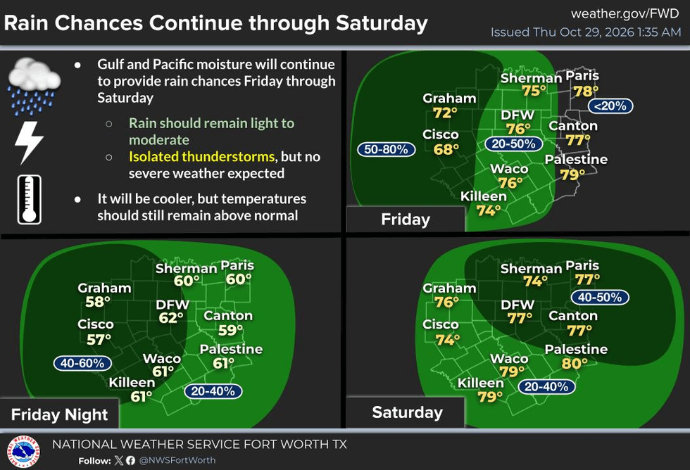
**HALLOWEEN WEEKEND FORECAST**
Saturday morning temperatures will start in the mid-60s, with the heaviest rainfall expected Friday evening into Saturday around midday. Fortunately, the rain should gradually move east of us as Halloween activities get underway. High temperatures Saturday may struggle to reach 70 degrees, so keep the cooler weather in mind if you're heading out for Halloween festivities.
We'll have the potential for a little more sunshine Sunday, with temperatures climbing toward 80 degrees. Monday will turn much warmer, with highs in the lower to middle 80s. That's unusually warm for this time of year, but a significant change is on the way.
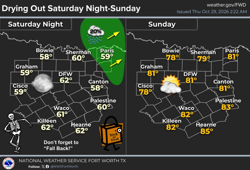
**A STRONG COLD FRONT ARRIVES NEXT WEEK**
A cold front will finally bring some much-needed cooler air into North Texas late Monday into Tuesday. The front will likely produce a line of showers and thunderstorms as it moves through the region.
I'll be keeping a close eye on the potential for severe weather. Hopefully, the front arrives closer to midnight or around daybreak Tuesday, which could help limit the severe threat. However, we cannot rule out strong storms just yet.
Even if severe weather doesn't develop, strong winds will be possible. Gusts could reach 40 mph Tuesday and continue into Wednesday as cooler air settles into the region.
High temperatures will fall to around 65 degrees Tuesday, with even cooler conditions Wednesday. By Thursday and Friday morning, temperatures will be down in the 50s.
After such a long stretch of quiet weather, we're finally looking at some meaningful changes across North Texas!
Have a great day, everyone! Thanks for following my weather updates. Please like and share this forecast to help keep North Texans weather aware!
7-Day Headlines:
- DFW Airport hit 83 degrees on Wednesday
- Rain inches closer today (highest coverage west of DFW)
- Increasing rain chances late Friday into noon Halloween
- Trick-or-Treaters will be dry. Temps in the 60s
- Daylight saving time ends early Sunday morning
- Warming up Sunday and Monday
- Late Monday cold front, watching out for strong/severe storms
- Download our AUDACY app! Listen to KRLD LIVE at home or at work
Almanac:
- Yest Rain: 0.00”; Yest High: 83; Low: 60
- Today’s Averages: High: 73; Low: 52
- Record high: 90 (1938); Record low 30 (1925)
- October rain: 3.94” ”; Surplus/Deficit: 0.00”
- 2026 Rain: 26.72”; Snow: 2.4”; Deficit: <4.49””>
- Sunrise: 7:44am; Sunset: 6:39pm
Forecast:
Thursday: Increasing clouds and warm. Scattered showers (west of DFW) by evening. High: Near 80. Wind: South 5-10 mph..
Thursday night: Cloudy and mild. Scattered showers. Low: Mid 60s. Wind: Variable 5-10 mph.
Friday: Cloudy and mild. Scattered showers and isolated storms (Increasing by evening). High: Near 70. Wind ENE 5-10 mph.
Halloween: Cloudy and cool. Scattered showers before noon. High: Upper 60s.
Sunday: Partly cloudy and warmer. High: Near 80.
Monday: Increasing clouds and warm. Scattered showers and storms late. High: Low 80s.
Tuesday: Morning cold front takes storms out of the area. VERY windy and cool. Wind gusts over 40 mph. High: Near 70.
Wednesday: Partly cloudy, windy and cool. High: Mid 60s.
LISTEN on the Audacy App
Tell your Smart Speaker to "PLAY 1080 KRLD"
Sign Up to receive our KRLD Insider Newsletter for more news


