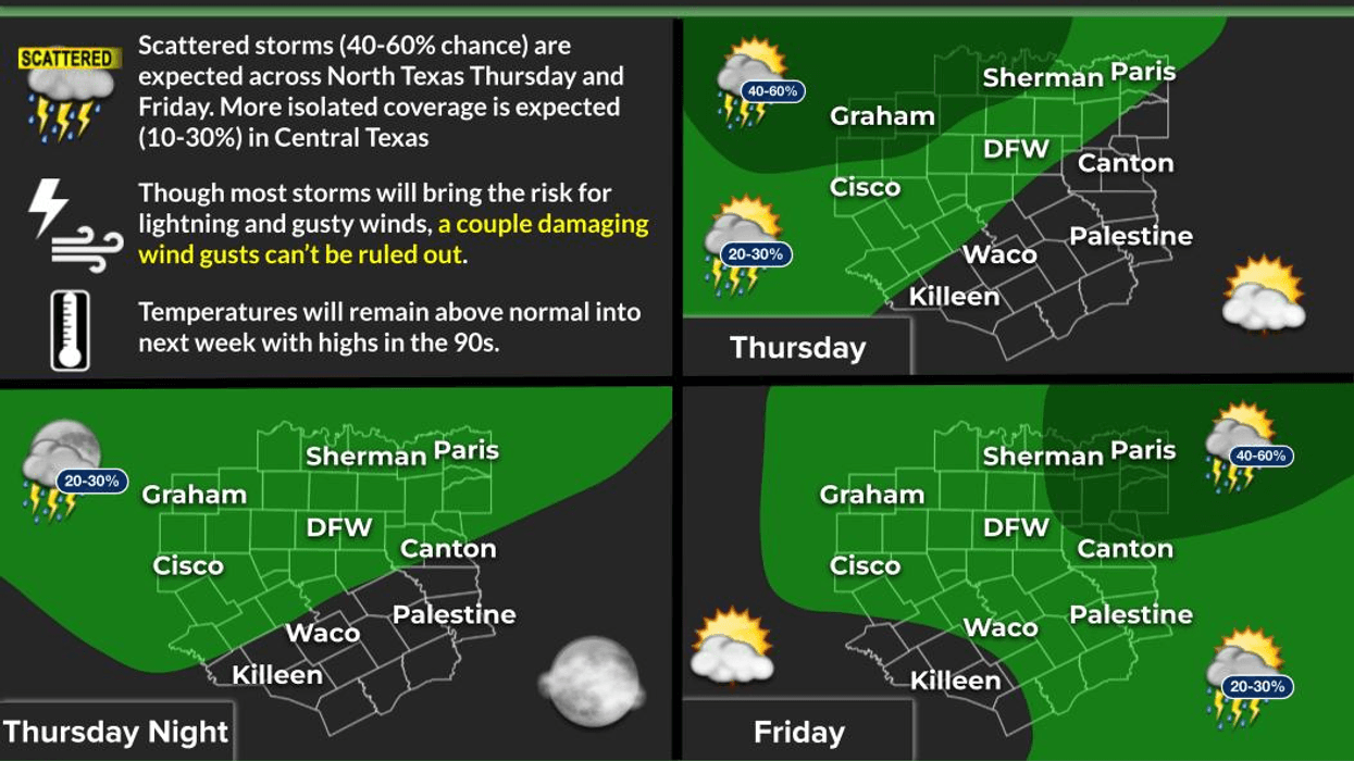

The heat advisories are gone, and we finally have a chance for some scattered showers and strong storms across the northern half of North Texas later today, especially this evening.
And yes, we’re still talking about the fact that DFW has not recorded measurable rainfall in nearly eight weeks. Hopefully, that changes today, and hopefully you get some rain in your backyard, too. Unfortunately, rain chances will be much slimmer south of Interstate 20.
Good morning, everyone. I hope you’ve had a great short work week so far.
We’re waking up to mainly clear skies across North Texas, with temperatures in the upper 70s to low 80s. The good news is there are no heat advisories today. That said, it’s still going to be hot, with afternoon temperatures climbing close to 100 degrees.
A weak cold front will push across the Red River after dinner tonight. Showers and thunderstorms will develop along and ahead of that front. The newest forecast guidance suggests storms may not be quite as numerous as previously expected, but some of you should see rain, especially north of Interstate 20.
Unfortunately, this activity will likely fall apart after midnight as temperatures drop into the mid to upper 70s.
There’s also a slight chance for a few leftover showers and storms tomorrow as another weak disturbance moves across the area. We’ll briefly get some northwesterly flow, with afternoon highs again reaching the upper 90s.
Then high pressure begins building back over North Texas into the weekend and through much of next week.
Today, look for highs near 100 degrees with morning lows around 80.
And looking ahead to Monday, Tuesday and Wednesday, the winds are expected to increase, which means grass fire danger will really begin to ramp up. Please remember that there are burn bans in effect across portions of North Texas, so keep that in the back of your mind.
Beyond the seven-day forecast, some of the longer-range trends are hinting at another possible cold front arriving next Friday or Saturday. That’s still well beyond my seven-day forecast, so I’ll continue watching the trends as we get closer.
Fall officially arrives in 12 days, and the last week of September is typically when we start looking for our first noticeable cooldown or true taste of fall.
Have a great day today, and enjoy the weather when you can.
It’s the only weather you’ve got!
7-Day Headlines:
- DFW Airport hit 101 degrees (tied record) on Wednesday
- 45 triples this summer
- 56 days with no measurable rain at DFW
- No Heat Advisory today
- Cold front flirts with us later today. Possible storms!!
- Slight storm chance on Friday
- Staying unseasonably hot through next week
- Download our AUDACY app! Listen to KRLD LIVE at home or at work
Almanac:
- Yest Rain: 0.00”; Yest High: 101R; Low: 82
- Today’s Averages: High: 90; Low: 71
- Record high: 101 (2010); Record low 55 (2020)
- September rain: 0.00”; Deficit: <0.78”>
- 2026 Rain: 22.61”; Snow: 2.4”; Deficit: <2.82”>
- Sunrise: 7:09am; Sunset: 7:40pm
Forecast:
Thursday: Mostly sunny early, then increasing clouds and hot. Near record heat. Scattered late day and evening showers and strong storms. High: 100. Wind: SE 5-10 mph.
Thursday night: Mostly cloudy and mild. A few leftover showers. Low: Mid to upper 70s. Wind: North 5-10 mph.
Friday: Partly cloudy and hot. Scattered afternoon and evening showers and storms. Most of you stay dry. High: Upper 90s. Wind: South 5-10 mph.
Weekend: Partly cloudy and hot. Highs: Upper 90s..
Monday - Wednesday: More of the same. Partly cloudy and hot. Highs: Near 100.
LISTEN on the Audacy App
Tell your Smart Speaker to "PLAY 1080 KRLD"
Sign Up to receive our KRLD Insider Newsletter for more news
Follow us on Facebook | Twitter | Instagram | YouTube