An active weather pattern has persisted across parts of the United States over the past few days, and it will remain active for at least the next couple of days.
Friday morning, scattered showers streamed into North Texas from the south, with the severe threat shifting to Oklahoma. There will continue to be scattered showers and isolated thunderstorms throughout the day, with temperatures hovering around 60 degrees.
By late afternoon and evening, widespread severe thunderstorms will develop east of a Paris-to-Tyler-to-Palestine line. These storms will rapidly move northeast, eliminating any severe weather threats from Texas before midnight. North Texas will continue to experience scattered showers and isolated storms throughout the evening, with no severe weather expected.
An area of heavy rain will move in from the west before sunrise. Saturday morning, North Texas may witness an embedded line of storms rolling through the area, with a system slowly moving across the region. While stronger storms may produce small hail and wind gusts up to 40 mph, they will dissipate from west to east before noon. Rainfall totals of 1-3 inches are expected, with isolated higher totals east of the Dallas-Fort Worth area. Temperatures will remain in the 50s throughout the day.
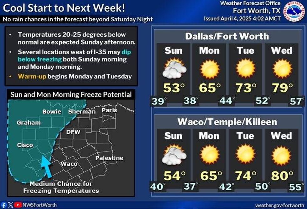
The strong upper-level low that has been stagnant across the Four Corners region will move into the Texas Panhandle on Saturday night, producing heavy, wet snow in the Panhandle and South Plains. There is also a possibility of snow in the mountains of West Texas by Sunday morning. Dallas-Fort Worth will continue to experience light rain on Saturday night through Sunday morning, with slow clearing during the day. Afternoon highs on Sunday will range from 48-53 from east to west.
The weather next week is expected to be fantastic. Morning lows will be in the 40s and 50s, with afternoon highs returning to the 70s on Monday and Tuesday, and the 80s on Wednesday and Thursday, all under clear skies.
 National Weather Service
7-Day Headlines
DFW reached 69 degrees on Thursday. 0.04" of rain.
Morning severe storms to the northwest, Scattered showers, and storms for Dallas-Fort Worth.
Storm Watch north and west of DFW until 10 a.m.
More strong to severe storms, from Dallas to the east Friday evening.
Waves of heavy rain late Friday into Saturday early afternoon. Rain totals: 1-3 inches.
Much cooler late Saturday through Monday.
*Thursday Rain: 0.04"; Thursday High: 69 Low: 56
*Friday's Averages: High: 74; Low: 52
*Record high: 94 (1940): Record low: 31 (1920)
_________________________________________________________
*April Rain: 0.19"; Deficit:
*2025 Rain: 8.90"; Surplus: 0.01"
*Sunrise: 7:10am; Sunset: 7:51pm
_________________________________________________________
Friday: ** Severe Thunderstorm Watch north of DFW until 10 a.m. ** Scattered morning severe storms, then scattered showers and storms through. Threats: Hail and damaging wind. Highs: Low 60s. Wind: NE 10-15 mph.
Friday night: Cloudy and cool. Scattered evening severe storms, mainly east of DFW. Threats: Large hail, damaging wind, and isolated tornadoes. Low: Low 50s. North 10-15 mph.
Saturday: Morning showers and strong storms through noon, a break in the afternoon, showers by evening through the overnight. Windy and colder. Highs: Steady in the 50s. Wind: North 15-25, G30 mph.
Sunday: Morning clouds/drizzle, clearing by late afternoon. Windy and chilly! High: 48-52.
Monday: Mostly sunny and perfect. High: Upper 60s.
Tuesday: Mostly sunny and comfortable. High: Mid-70s.
Wednesday: Sunny and beautiful! High: Low 80s.
Thursday: Sunny and warm. High: Mid-80s.
LISTEN on the Audacy App
Tell your Smart Speaker to "PLAY 1080 KRLD"
Sign Up to receive our KRLD Insider Newsletter for more news
Follow us on Facebook | Twitter | Instagram | YouTube