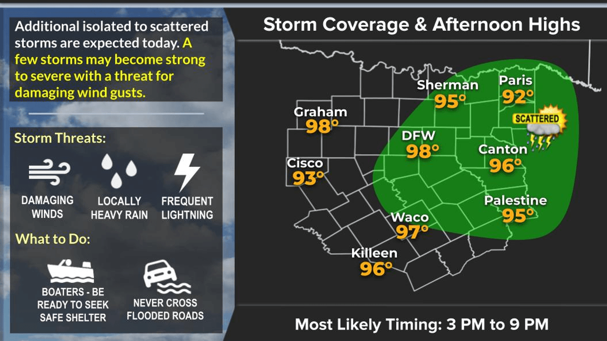

If you were one of the lucky ones who caught a shower or thunderstorm yesterday, there's a chance you'll see the same thing again today and tomorrow!
Good Tuesday morning! I hope everyone is off to a great start.
Scattered showers and thunderstorms will be possible between 3:00 PM and 9:00 PM today and again tomorrow. Most of North Texas will stay dry, but if a storm develops over your neighborhood, it could produce:
- Frequent lightning
- Brief damaging wind gusts
- Small hail
These storms won't move very much. They'll tend to form, rain themselves out, then send out boundaries that spark new storms nearby. That's exactly what happened yesterday near Frisco, where one storm sat over the area for about 45 minutes before triggering additional storms.
High temperatures today and tomorrow will climb into the upper 90s. We're flirting with 100° on Thursday and Friday, with the best chances for 100 degrees temperatures staying west of Fort Worth. South winds will increase to 15–25 mph later this week, which should provide at least a little relief in the shade.
Looking ahead to the weekend and early next week, a weakness in the upper levels will keep a slight chance of late-day showers and storms in the forecast—especially Sunday and Monday. It won't be a washout, just isolated "pop-up" storms similar to what we're seeing now. The good news is temperatures should ease back into the mid-90s.
Have a great Tuesday, and enjoy the weather when you can... it's the only weather you've got!
7-Day Headlines:
- DFW Airport hit 99 degrees on Monday
- Isolated late-day (3pm-9pm) showers and strong storms today and Wednesday
- Threats: Lightning, small hail, wind
- Flirting with 100 degrees all week
- Wind returns Thursday - Sunday
- Storm chances return late into the weekend
- Download our AUDACY app! Listen to KRLD LIVE at home or at work
Almanac:
- Yest Rain: 0.00”; Yest High: 99; Low: 76
- Today’s Averages: High: 95; Low: 75
- Record high: 106 (1996); Record low 64 (1968, 1972)
- July rain: 0.00”; Deficit: <0.60”>
- 2026 Rain: 21.25”; Snow: 2.4”; Surplus: 0.36”
- Sunrise: 6:27am; Sunset: 8:40pm
Forecast:
Tuesday: Partly cloudy and hot. Scattered late day (3pm-9pm) showers and storms. Threats: Lightning, small hail, damaging wind. High: Upper 90s. Heat index: Near 102 degrees. Wind: Variable 5 mph.
Tuesday night: Partly cloudy, mild and muggy. Low: mid to upper 70s. Wind: South 5 mph.
Wednesday: Partly cloudy and hot. Isolated late day (3pm-9pm) showers and storms. Threats: Lightning, small hail, damaging wind. High: Upper 90s. Heat index: Near 102 degrees. Wind: South 5-10 mph.
Thursday and Friday: Mostly sunny and hot. High: Upper 90s. Heat index near 103.
Weekend. Partly cloudy, breezy and hot. Scattered late day showers and storms. Highs: Mid 90s.
Monday: Partly cloudy, hot and humid. Scattered late day showers and storms. High: Mid 90s.
LISTEN on the Audacy App
Tell your Smart Speaker to "PLAY 1080 KRLD"
Sign Up to receive our KRLD Insider Newsletter for more news
Follow us on Facebook | Twitter | Instagram | YouTube