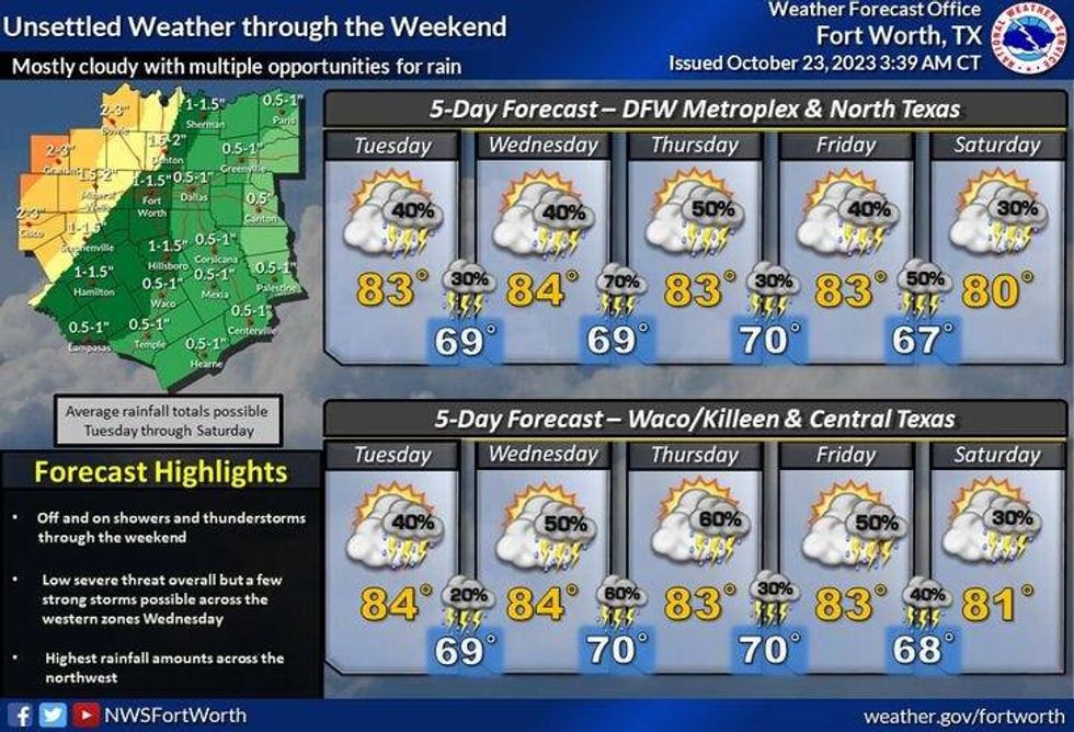
Scattered showers and isolated thunderstorms are in the forecast later today into tomorrow, with another chance for showers and storms late Wednesday into Thursday morning, isolated showers and storms on Friday, and increasing rain chances by Sunday along a strong cold front that will move through before the end of the day.
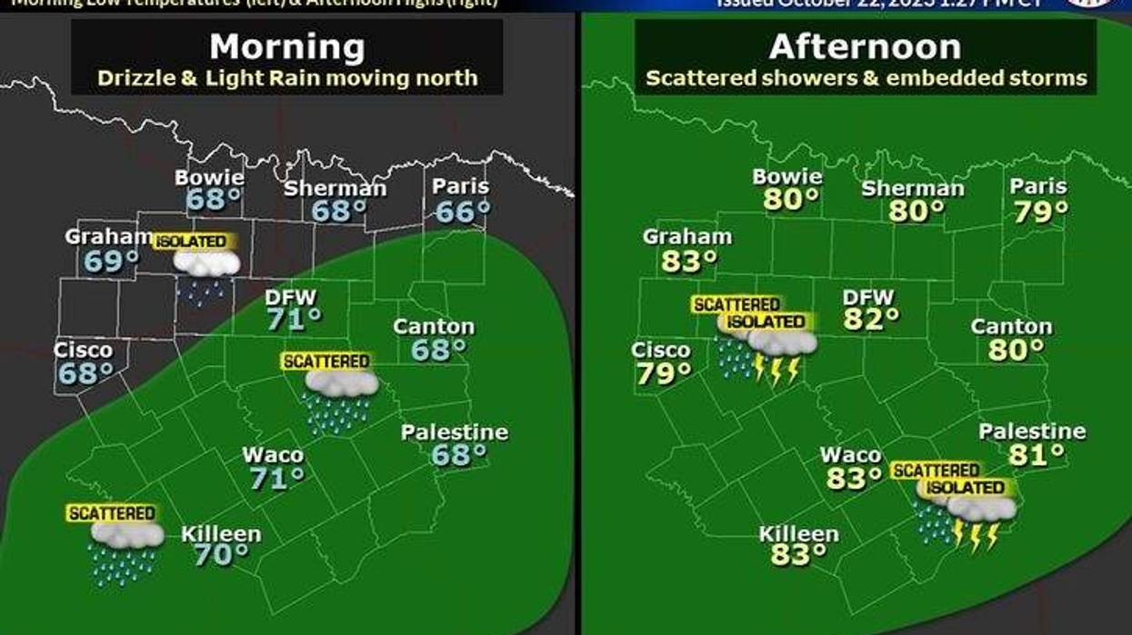
Monday begins with temperatures in the 70s with extensive cloud cover. Scattered showers are starting to develop to the south and southwest of North Texas. This area of rain will increase in coverage through the afternoon and evening. A lot of you will see some rain, but some of you won't see a drop. Afternoon highs today will be near 80°.
Scattered showers will continue to move across parts of North Texas overnight with lows near 70°.
Another area of rain will develop to our southwest tomorrow and move across North Texas during the day. As of now, it looks like the more widespread rain will stay west of the Dallas and Fort Worth areas. High temperatures will once again top out near 80°.
 National Weather Service - Fort Worth
Wednesday will be mostly cloudy, windy, and humid. There may be a few isolated showers around with high temperatures near 80°. Rain chances will increase rapidly late Wednesday evening into early Thursday as a line of showers and storms moves across the area. The severity looks to remain low, but gusty winds are possible in areas through the overnight.
After the rain moves to our east Thursday morning, the rest of the day looks mainly dry with peaks of sunshine. High temperatures will top out in the mid-80s.
Friday looks mostly cloudy with a chance of scattered showers. High temperatures will reach the lower 80s.
More clouds than sun on Saturday with an isolated shower possible. Afternoon highs will top out in the low 80s again.
Sunday is a tricky forecast. Some model data suggests a strong cold front will move through the first half of the day, other model data holds it off until Monday. Once the front finally arrives, scattered showers and storms will break out along and behind the front. Temperatures will be sharply colder next week. I'll know a lot more about the timing of the front as the week moves on.
*Yest Rain: 0.00"; Yest High: 85; Low: 64
*Today's Averages: High: 76; Low: 54
*Record high: 91 (1925, 1939): Record low: 36 (1917, 1990)
*October Rain: 1.04"; Deficit: 1.94
*2023 Rain: 16.70"; Deficit: 13.55
*Sunrise: 7:38am; Sunset: 6:46pm
Today: Cloudy, breezy and muggy. Scattered showers and isolated storms. Nothing severe. High: Near 80. Wind: South 10-20, G25 mph.
Tonight: Cloudy, breezy and muggy. Scattered showers possible. Low: Near 70. Wind: South 10-20 mph.
Tuesday: Cloudy, windy and mild. Scattered showers and storms. Heaviest west of I-35W. High: Near 80. Wind: South 15-25, G30 mph.
Wednesday: Cloudy, windy and mild. Isolated afternoon showers. Storm chances increase by late evening. Threat: Damaging wind. High: Near 80.
Thursday: Morning rain, some afternoon sun. Breezy. High: Mid 80s.
Friday: Partly cloudy and mild. Isolated showers and storms. High: Low 80s.
Saturday: Partly cloudy and mild. Isolated showers. High: Low 80s.
Sunday: Cloudy, with a decent chance for rain. Cold front arrives by the end of the day. High: Upper 70s.
LISTEN on the Audacy App
Tell your Smart Speaker to "PLAY 1080 KRLD"
Sign Up to receive our KRLD Insider Newsletter for more news
Follow us on Facebook | Twitter | Instagram | YouTube