


We're waking up to temperatures in the 70s this morning with extensive cloud cover. There may be some patchy drizzle around through mid morning. Afternoon highs today will reach the low 80s. There may also be some severe storms breaking out, just east of the Dallas/Fort Worth area (along Central Expressway and I-45) by early to mid afternoon.
These storms will rapidly race off to the East. I'm not overly concerned about a severe weather outbreak across North Texas, most areas won't even see a drop.
A totally different story mainly east of the Mississippi River tonight into tomorrow. This is where levels 4 out of 5 are in place.
 National Weather Service - Fort Worth
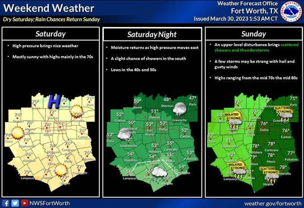
A beautiful start to the weekend. Morning lows in the upper 40s to low 50s with highs in the low to mid 70s tomorrow.
Most of Sunday is OK with the chance for some strong isolated severe storms by Sunday evening. I'm not overly concerned but I will monitor just in case. Afternoon hives will reach the mid 70s again.
 National Weather Service - Fort Worth
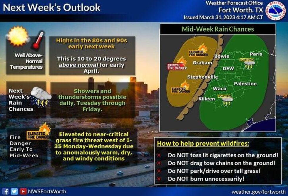
Monday and Tuesday are downright warm. Windy conditions with highs near 90゚. There's a slight chance for a few storms late Monday evening and then again Tuesday evening.
Cooler weather arrives Wednesday through the end of the week with high temperatures only in the sixties, the next best rain chance will arrive late Thursday Friday and maybe even in the Saturday as well. Stay tuned. Flooding may be a concern.
*Yest Rain: 0.01"; Yest High: 73 Low: 60
*Today's Averages: High: 73; Low: 52
*Record high: 96 (1974); Record low: 28 (1907)
*March Rain: 2.76"; Deficit: 0.44"
*2023 Rain: 8.11"; Deficit: 0.38"
*Sunrise: 718am; Sunset: 7:48pm
Today: Morning clouds and drizzle. Decreasing clouds by afternoon, windy and warmer. Scattered showers and isolated severe storms (Dallas....east) early this afternoon. Threats: Hail and wind. High: Low to mid 80s. Wind: SW 20-30, G35 mph.
Tonight: Clear and cool. Low: 47-52. Wind: West 10-20 mph.
Saturday: Sunny and perfect. High: Mid 70s. Wind: NW 10-20 mph.
Sunday: Partly to mostly cloudy, breezy and pleasant. Scattered afternoon and evening showers and isolated severe storms. Windy and mild. High: Mid 70s.
Monday and Tuesday: Partly cloudy, very warm and windy. Highs: Near 90.
Wednesday: Partly cloudy and cooler. High: Upper 60s.
Thursday: Rain likely. Breezy and cool. High: Low 60s.

LISTEN on the Audacy App
Tell your Smart Speaker to "PLAY 1080 KRLD"
Sign Up to receive our KRLD Insider Newsletter for more news


