We're waking up to temperatures near 60゚ with considerable cloudiness. There may be some patchy drizzle and light rain developing through the morning hours. There's also a chance for scattered showers and a rumble of thunder between 12 PM and 5 PM, a few of these may become severe between 5 PM and 8 PM, with hail being the primary threat. Areas along and north of highway 380 have a small chance for 1 or 2 severe storms. Afternoon highs will reach the low seventies, with a south wind gusting to 30 mph.
Make sure your tents are secure and that you bring an umbrella with you if you're gonna be tailgating for the Rangers game. 1st pitch is at 3:05 PM . Go Rangers! Listen live in DFW on 105.3 The Fan.
It will be very mild and windy tonight with extensive cloud cover. There may be some patchy drizzle as well by daybreak. Morning lows will only drop into the mid to upper sixties, with a south wind gusting to 35 mph.
 National Weather Service - Fort Worth
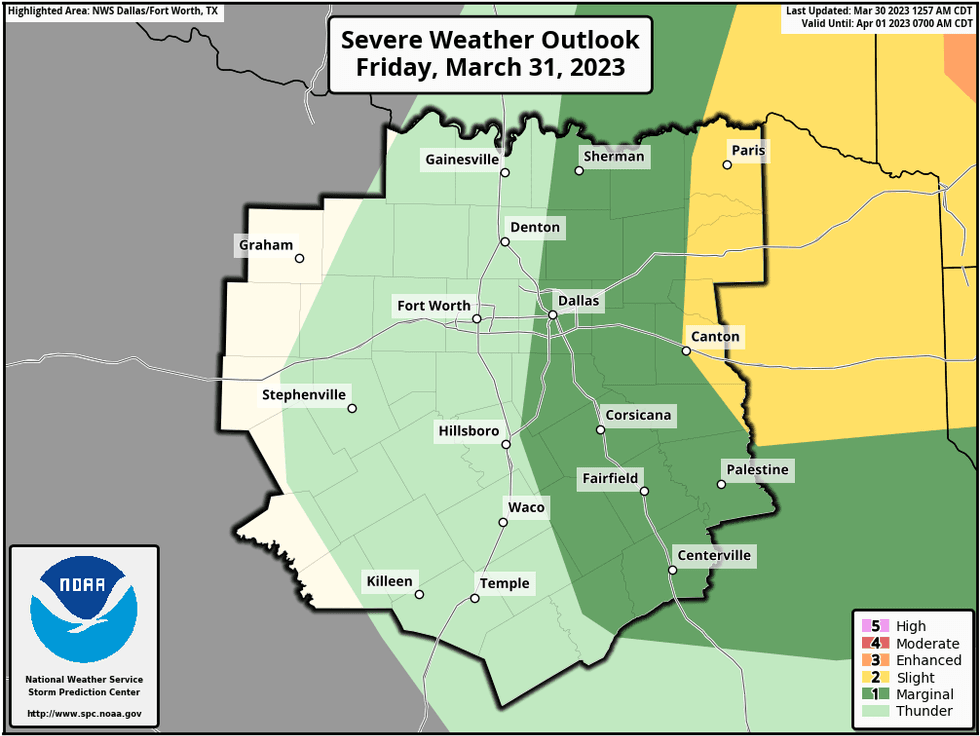
Plenty of cloud cover through early Friday afternoon, with a slight chance of a strong to severe storm forming along a line from McKinney to Dallas to Waxahachie during the early afternoon. A line of storms will form just east of this area and will continue to intensify and increase in coverage as it moves into east Texas. There will be severe storms in the piney woods by late afternoon into the evening hours. All modes and severe weather are possible.
Drier will sneak in from west Texas through the day, as skies clear from west to east. Afternoon highs will reach the low eighties. West winds will gust to 40 mph through the late afternoon and evening.
 National Weather Service - Fort Worth
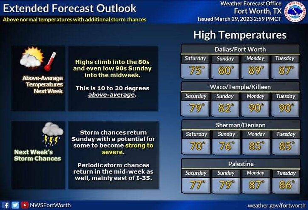
Saturday looks down like gorgeous! Plenty of sunshine with highs in the low to mid seventies. By Sunday, scattered showers and storms will start to break out by the afternoon into the early evening hours. A few storms could become severe. Afternoon highs will reach the mid seventies.
A taste of summer arrives next Monday and Tuesday with plenty of sunshine. Afternoon highs will reach near 90゚! It'll turn a bit cooler on Wednesday with highs and mid seventies, with a few scattered showers and storms around.
*Yest Rain: 0.00"; Yest High: 65 Low: 49
*Today's Averages: High: 73; Low: 51
*Record high: 95 (1946); Record low: 29 (1987)
*March Rain: 2.75"; Deficit: 0.34"
*2023 Rain: 8.10"; Deficit: 0.28"
*Sunrise: 7:19am; Sunset: 7:47pm
Today: Cloudy, breezy and warmer. Scattered showers and isolated strong storms noon to 5pm. Isolated severe DFW -> north 5pm-8pm. Threats: Hail and wind. High: Low 70s. Wind: SSE 10-20, G30 mph.
Tonight: Cloudy, windy, muggy and mild. Areas of drizzle. Low: Mid to upper 60s. Wind: SSE 15-25, G35 mph.
Tomorrow: Cloudy through early afternoon, becoming mostly sunny, windy and warm. A slight chance of strong to severe storms Dallas -> east. Best chance for severe storms in east Texas late this afternoon and evening. All modes of severe weather possible. High: Low 80s. Wind: Shifting west 20-30, G40 mph.
Saturday: Mostly sunny and perfect! High: Mid 70s.
Sunday: Partly to mostly cloudy, breezy and pleasant. Scattered afternoon and evening showers and severe storms. Windy and mild. High: Mid 70s.
Monday and Tuesday: Partly cloudy, very warm and windy. Highs: Near 90.
Wednesday: Partly cloudy and a bit cooler. Slight chance of showers and storms. High: Low 70s.

LISTEN on the Audacy App
Tell your Smart Speaker to "PLAY 1080 KRLD"
Sign Up to receive our KRLD Insider Newsletter for more news