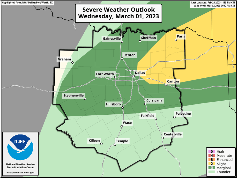
Scattered strong to isolated severe storms this morning with mild and muggy conditions, levels 2, 3, 4 out of 5 for large hail, damaging wind and isolated tornadoes tomorrow between 4pm and 9pm, MUCH cooler and drier Friday, and a rapid warm up into the weekend and into early next week.
A very powerful storm system is now working its way into central and Southern California at this hour. This system will rapidly head our direction by tomorrow afternoon and evening. This being said, a spoke of energy has spun off this system and is rapidly heading into north Texas this morning. This will produce scattered strong to isolated severe storms from 8am through noon. Pocket change sized hail and wind are the primary threats. Most of the rain will be east of the Metroplex by this afternoon. Afternoon highs will reach the mid seventies.
Tonight will be relatively quiet, with very balmy conditions. a few light showers are possible. Morning lows will only fall into the mid to upper sixties.
 NOAA
NOAA
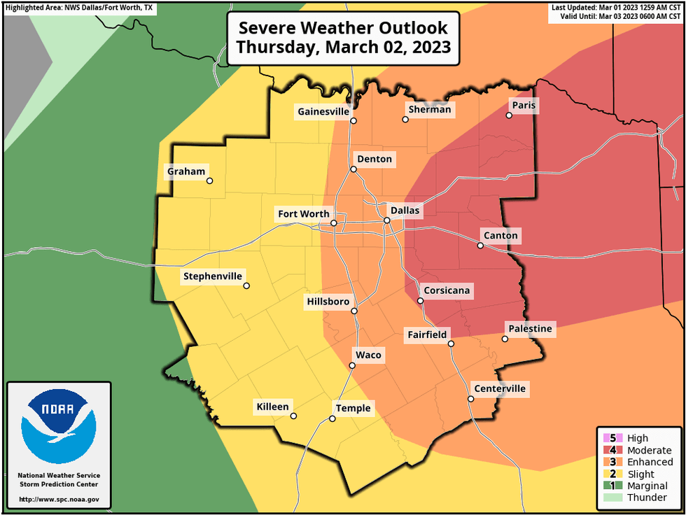
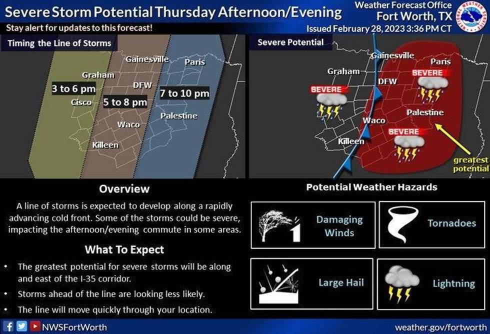
Tomorrow concerns me a bit and is the day to stay smart and weather aware. Another spoke of energy will cross the area tomorrow morning producing a few isolated strong to severe storms. The big weather player arrives tomorrow afternoon and evening with all modes of severe weather possible. Levels 2, 3, and 4 out of 5 have been placed across all of North Texas stretching into the eastern parts of the state.
 National Weather Service - Fort Worth
Very large hail, damaging wind, and isolated tornadoes are the threats. The track of THIS upper level low is much farther south than the last one that gave the severe weather across the Texas Panhandle and parts of Oklahoma a few days ago, Again, this concerns me. Please know where to go when severe weather strikes and keep it tuned to NewsRadio 1080am KRLD for updates over the next 36 hours.
 NOAA
NOAA
Everything presses east of north Texas before midnight tomorrow giving way for a cool and breezy Friday and a beautiful weekend to boot. Afternoon highs on Friday will only reach 60゚, Sunny and 65 for Saturday, high clouds and 75 for Sunday, and the warm up will continue into early next week, with eighties retarding to the area.
I encourage everybody to please stay weather aware, know your tornado safety rules.
*Yest Rain: 0.00"; Yest High: 85; Low: 48
*Today's Averages: High: 64; Low: 44
*Record high: 93 (2006); Record low: 18 (1922)
*February Rain: 3.97"; Surplus: 1.21"
*2023 Rain: 5.35"; Surplus: 0.06"
*Sunrise: 6:56am; Sunset: 6:25pm
Today: Mostly cloudy, warm and humid. Scattered strong to severe storms. Timing: 10-am-1pm. Threats: Smaller hail and damaging wind. High: Mid 70s. Wind: SSW 10-20 mph.
Tonight: Cloudy, breezy and muggy. A few showers. Low: Mid to upper 60s. Wind: South 10-20, G30 mph.
 National Weather Service - Fort Worth
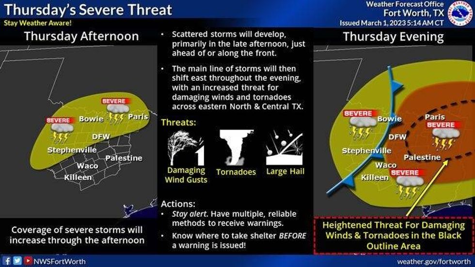
Thursday: Cloudy, breezy and muggy. Scattered morning strong storms, then scattered afternoon and evening severe storms. Levels 2-4 out of 5. Timing: 4pm-9pm. Threats: Large hail, damaging wind, isolated tornadoes. High: Mid 70s. Wind: South 10-20, G30 mph.
Friday: Clearing, windy and cooler. High: Upper 50s.
Saturday: Sunny and cool. High: Mid 60s.
Sunday: Sunny, breezy and pleasant. High: Mid 70s.
Monday and Tuesday: Partly cloudy, windy and warm. High: Low to mid 80s.

LISTEN on the Audacy App
Tell your Smart Speaker to "PLAY 1080 KRLD"
Sign Up to receive our KRLD Insider Newsletter for more news