A pattern is gradually changing and unfolding across North Texas over the coming days, leading to an increase in shower and thunderstorm activity. A few of these storms may become severe late in the weekend and early next week.
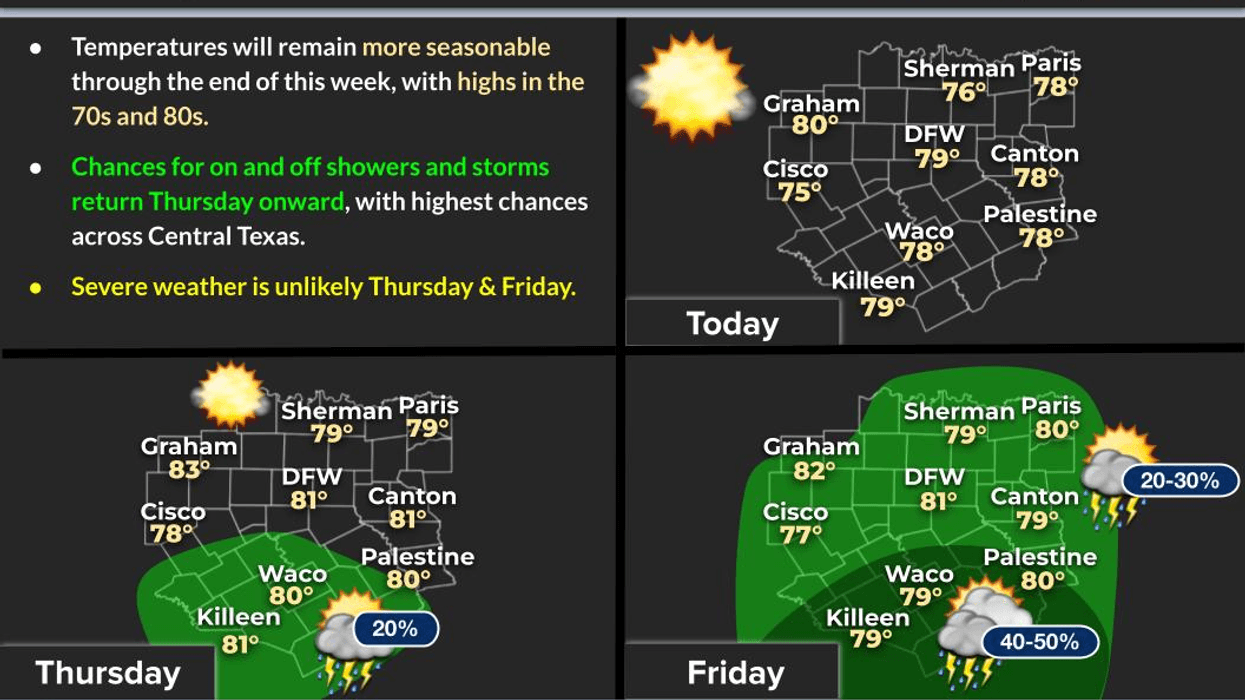
Good morning. We are waking up to a partly cloudy sky with temperatures in the 50s. A light jacket may be necessary for some. A beautiful day is ahead, with temperatures reaching the upper 70s and a south wind at 10 to 15 mph. Thursday is expected to be similar, with morning lows near 60 and afternoon highs approaching 80 degrees under a partly cloudy sky.
Changes are expected to begin on Friday, as a decent upper-level disturbance cruises across South Texas, bringing welcome rain to those areas. Some of these showers and isolated strong storms will move towards the Dallas-Fort Worth area in the late afternoon and evening, with the greatest coverage south of Interstate 20. Afternoon highs will reach 80 degrees.
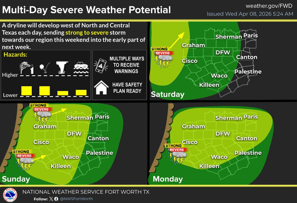
Keep your umbrella handy this weekend, as scattered showers and storms will move in from the south and west through Saturday evening. A few strong to severe storms are possible west of the Dallas-Fort Worth area, but scattered showers and storms are expected around the area through the evening hours, with the highest coverage south of DFW.
Sunday is expected to be mostly partly cloudy, with afternoon highs near 80 degrees again. Storms will start to develop west of the Dallas-Fort Worth area during the afternoon hours and will likely form into a line of storms as they move into the area late Sunday evening and early Monday morning. Some of these storms have a chance to become severe. I will monitor the weather throughout the weekend and provide live updates on NewsRadio 1080 KRLD AM and Facebook as necessary.
Additional storms are forecasted for late Monday afternoon into the evening hours, as well as Tuesday. Stay tuned for updates on that forecast. Afternoon highs will reach the low 80s.
It's April in Texas, and typically, we start to see an increase in severe weather. Mother Nature appears to be cooperating. Please ensure you have multiple ways to receive warnings, download our Audacy app on your phone to listen to us 24/7.
Have a terrific day today and enjoy the weather when you can, it’s the only weather you’ve got!
7-Day Headlines:
- DFW Airport reached 73 on Sunday.
- Morning sprinkles, afternoon sun today.
- Slightly above average temperatures through the weekend.
- Gulf moisture slowly returns into the weekend.
- Storm chances increase late Saturday - Tuesday.
- Some storms MAY become severe.
Almanac:
- Yest Rain: 0.00”; Yest High: 73; Low: 51
- Today’s Averages: High: 75; Low: 53
- Record high: 97 (2020); Record low 32 (1980)
- April rain: 2.59”; Surplus: 1.90”
- 2026 Rain: 7.75”; Snow: 2.4” Deficit: <1.53”>
- Sunrise: 7:06am; Sunset: 7:54pm
7-Day Forecast:
- Wednesday: A few morning sprinkles, afternoon sun. High: Upper 70s. Wind: SE 5-10 mph.
- Wednesday night: Partly cloudy and comfortable. Low: Near 60. Wind: SE 5-10 mph.
- Thursday: Partly cloudy and a tad warmer. High: Near 80. Wind: SE 10-20 mph.
- Friday: Partly cloudy, breezy and warm. A few showers and storms late in the day. Best chance south of DFW. High: Near 80.
- Saturday: Mostly to partly cloudy, breezy and warm. Scattered showers and storms late. Highest coverage west of DFW. High: Near 80.
- Sunday: Mostly cloudy, breezy and warm. Scattered strong thunderstorms by evening. Isolated severe. High: Near 80.
- Monday and Tuesday: Partly cloudy, breezy and warm. Scattered showers and storms. High: Near 80.