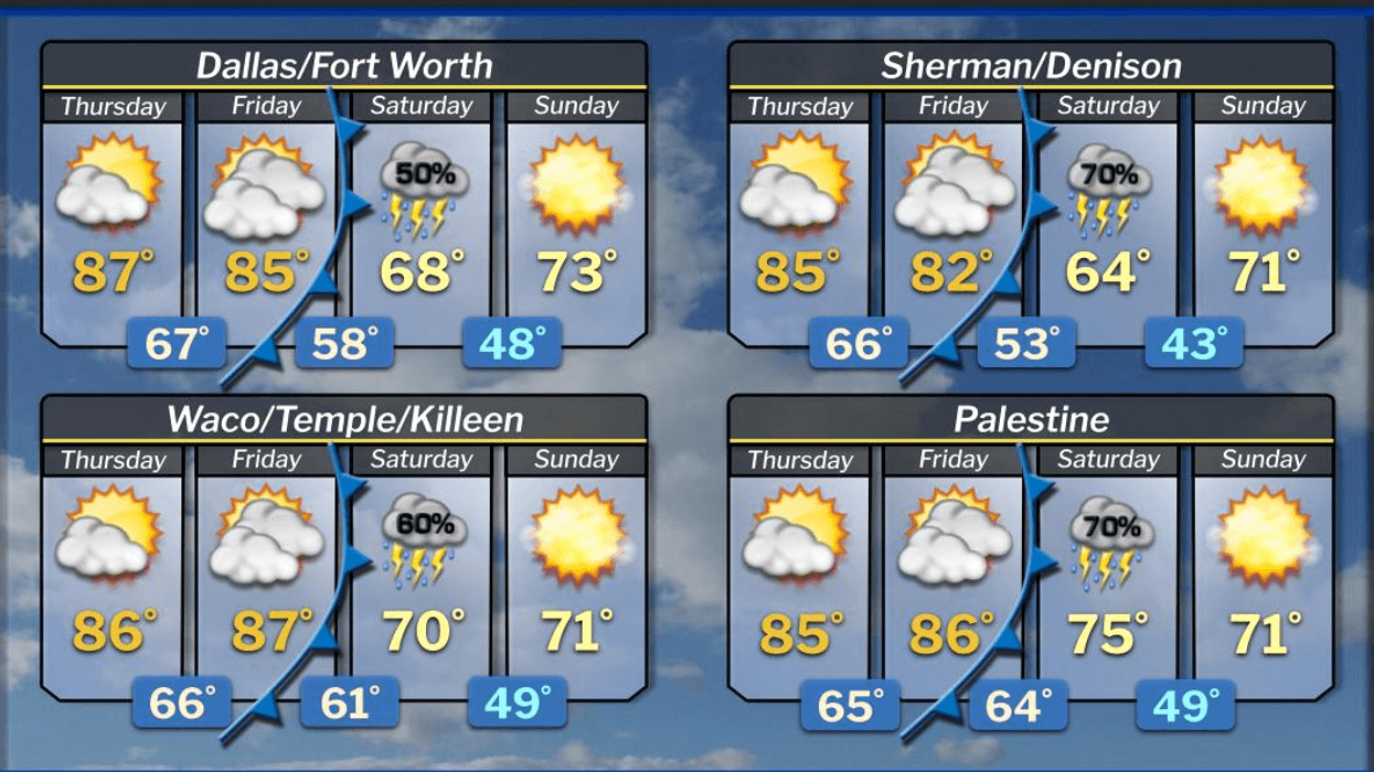
There is on-and-off shower and thunderstorm activity in the forecast through Saturday morning, and some of the storms may become severe with wind and hail up to the size of quarters.
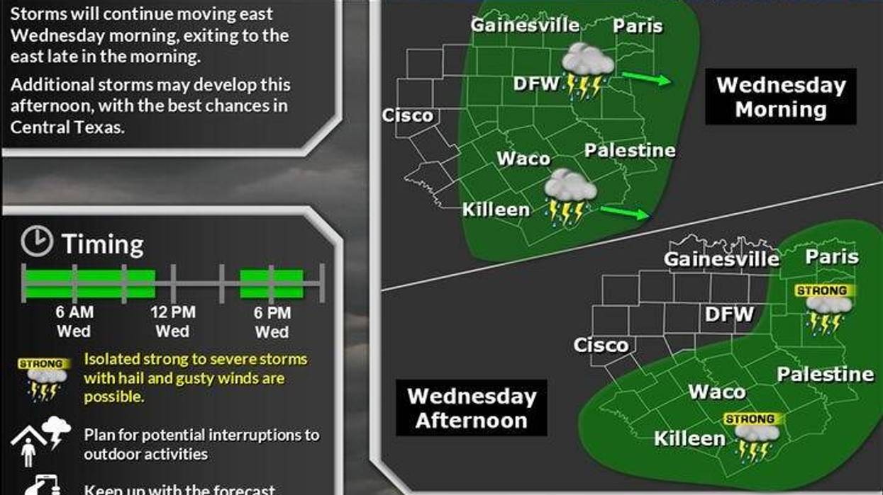
There were reports of up to 2 inches of rain across parts of North Texas on Wednesday morning, as well as hail up to the size of quarters. The axis of heavy rain and thunder will continue to move east of the Dallas-Fort Worth area through mid-morning.
Showers and storms will redevelop after the noon hour across the Dallas-Fort Worth area and especially in East Texas. There may be a few storm warnings for quarter-sized hail and wind in excess of 60 mph in these areas. Also, flash flooding is a possibility, especially along creeks and streams. Afternoon highs will struggle to hit 80 degrees.
Storms will once again form in far West Texas late Wednesday afternoon and then again Thursday afternoon and Friday afternoon. These storms will migrate east through the early morning hours and possibly plague the morning commute for Thursday and Friday. Afternoon highs will struggle to hit 80 degrees each day. Flooding may be a concern throughout the period due to the saturated ground in areas.
A cold front will enter the Texas Panhandle and approach the Red River Valley by Friday afternoon and evening. A large area of showers and storms will form along this front and may plow through North Texas Friday evening into Saturday morning. Damaging wind would be the main threat. Afternoon highs will reach near 80 degrees.
Some extended data continues to show scattered showers and thunderstorms on Saturday with highs in the low 80s. Things will dry out briefly Sunday and Monday before scattered strong to severe storms return to the area next Tuesday and Wednesday.
7-Day Headlines
DFW hit 87 degrees on Tuesday.
Scattered showers and storms are expected through Saturday. Some severe.
Threats: Hail and wind. Welcome rain!
Drying out Sunday and Monday. Humidity!
Getting active again on Tuesday and Wednesday of next week.
*Tuesday Rain: 0.00"; Tuesday High: 87 Low: 58
*Wednesday's Averages: High: 78; Low: 57
*Record high: 90 (1934): Record low: 41 (1907, 2013)
_________________________________________________________
*April Rain: 1.59"; Deficit:
*2025 Rain: 10.30"; Deficit:
*Sunrise: 6:48am; Sunset: 8:05pm
_________________________________________________________
Wednesday: Mostly cloudy and warm. Scattered showers and isolated severe storms. Threats: Hail and wind. High: Near 80. Wind: South 5-10 mph.
Wednesday night: Mostly cloudy and mild. Scattered showers and storms before daybreak. Isolated severe storms are possible. Threats: Hail and wind. Low: Mid 60s. South 5-10 mph.
Thursday: Partly cloudy and warm. Scattered showers and storms. Isolated severe. High: Low 80s.
Friday: Partly cloudy and humid. Scattered showers and storms. Isolated severe. High: Low 80s.
Weekend: Mostly to partly cloudy. Scattered strong storms on Saturday. Windy and warm. Highs: 83-87.
Monday: Partly cloudy, windy, and warm. High: Mid to upper 80s.
Tuesday: Scattered strong storms return. High: Mid 80s.
LISTEN on the Audacy App
Tell your Smart Speaker to "PLAY 1080 KRLD"
Sign Up to receive our KRLD Insider Newsletter for more news
Follow us on Facebook | Twitter | Instagram | YouTube