A couple of warm days, early morning Saturday showers along a strong cold front, a cool weekend, a few showers early next week, and then a warming trend after that.
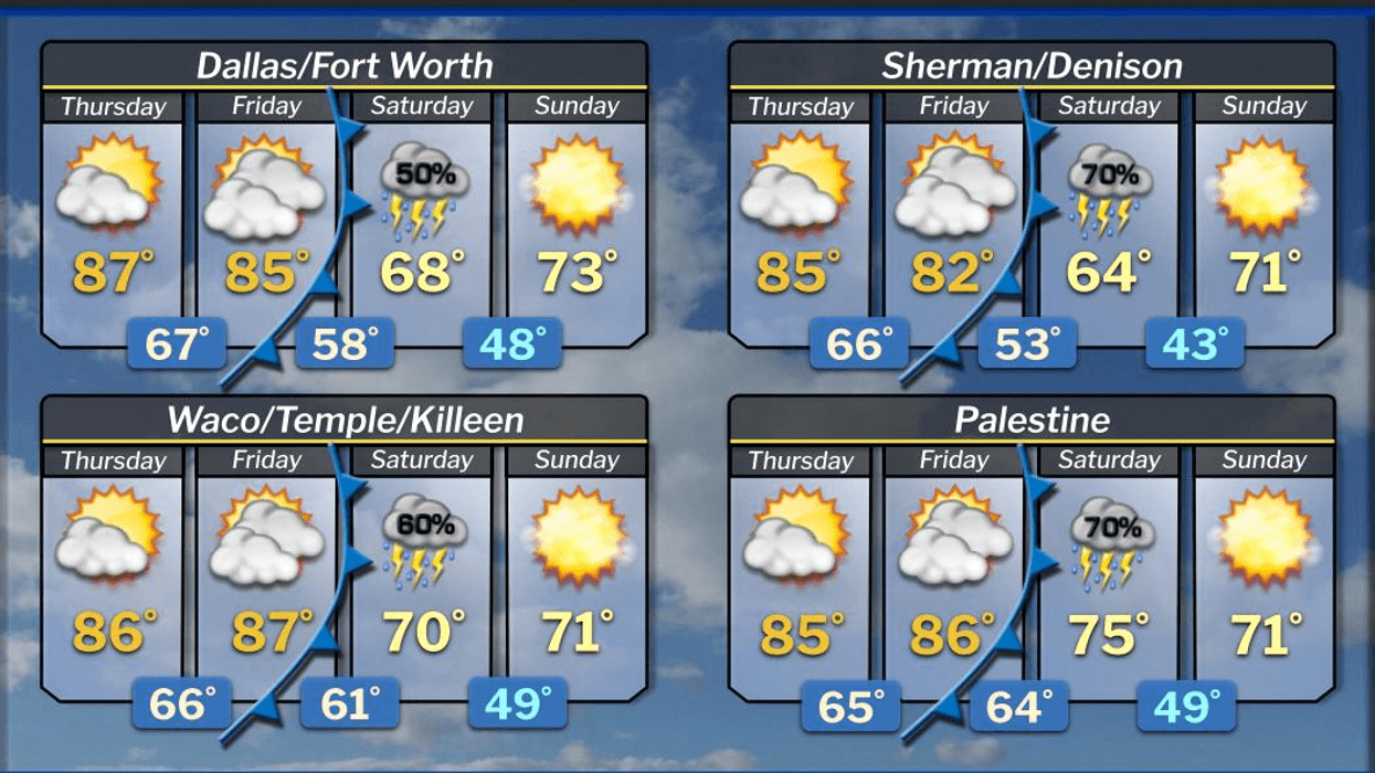
Good morning, and happy almost Friday. We successfully navigated last night's weather. Areas northwest and north of the Dallas-Fort Worth area experienced hail, welcome rain, and significant noise. This morning, the weather calmed under a partly cloudy sky. Temperatures have dropped to the mid-to-upper 60s across North Texas. Today, sunshine will prevail, accompanied by very warm temperatures. Afternoon highs will reach the mid-to-upper 80s, with south winds blowing at 15 to 25 mph.
Low clouds will return Friday morning, with lows near 70°F. Breezy conditions will prevail under a partly cloudy sky, with afternoon highs reaching the low to mid-80s. South winds will gust up to 30 mph.
Our next weather change will arrive around sunrise on Saturday. A cold front will sweep through the area, bringing showers and isolated thunderstorms, along with significantly cooler temperatures. Readings will be in the low 70s at 4:00 a.m., near 50°F by 9:00 a.m., and will slowly warm to the low 60s by afternoon. Clouds will be slow to clear, but the clearing line will move in from northwest to southeast during the afternoon, allowing for a visible sunset.
On Sunday, lawn mowers will be active across neighborhoods. Morning lows will be comfortable for a morning walk, with readings dropping into the mid-to-upper 40s. Afternoon highs will warm into the low 70s, with low humidity prevailing under plenty of sunshine.
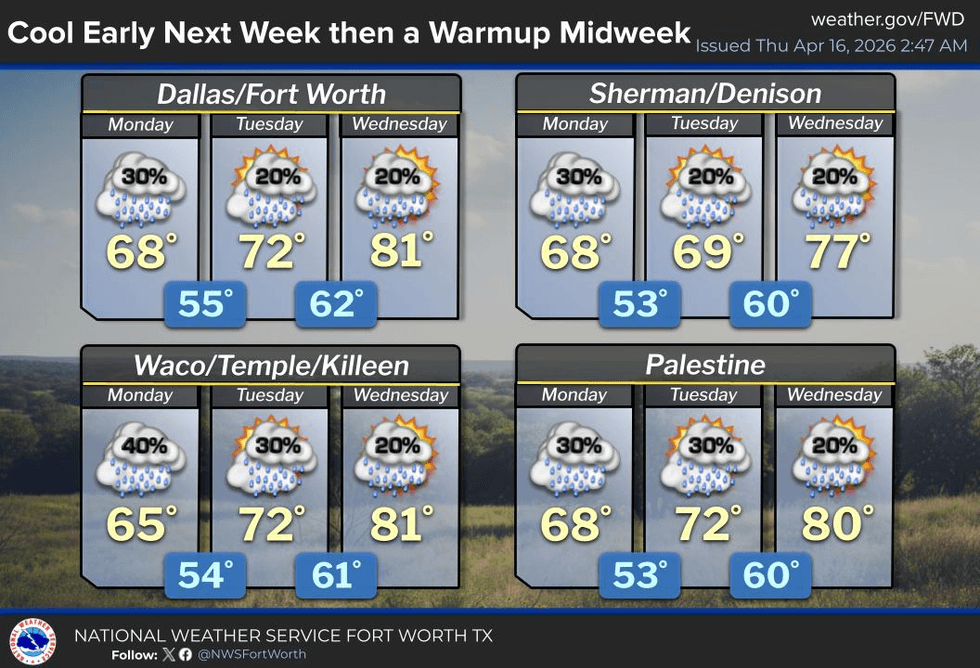
By Monday, an upper-level disturbance will slowly move across South Texas, spreading abundant cloud cover over North Texas. This may result in a few sprinkles during the day. Measurable rain will remain across central, south, and southeast Texas on Monday and Tuesday. Tuesday is expected to be mainly dry, with slow clearing anticipated before the day's end. Afternoon highs on Monday may not exceed the 60s, with low 70s expected on Tuesday, and mostly sunny low 80s returning by Wednesday.
Have a terrific day today, and please enjoy the weather when you can; it's the only weather you've got.
7-Day Headlines:
- DFW Airport reached 79 on Wednesday.
- Warm and dry through Friday.
- Saturday morning's cold front brings quick rain.
- MUCH cooler this weekend.
- A PERFECT Sunday!
- A few showers on Monday
- Download our AUDACY app. Listen to KRLD at home!
Almanac:
- Yest Rain: 0.01”; Yest High: 79; Low: 70
- Today’s Averages: High: 76; Low: 55
- Record high: 95 (1905); Record low 36 (1905)
- April rain: 2.71”; Surplus: 1.24”
- 2026 Rain: 7.87”; Snow: 2.4” Deficit: <2.19”>
- Sunrise: 6:56am; Sunset: 8:00pm
Forecast:
- Thursday: Morning clouds, then mostly sunny, warm, and windy. High: Mid to upper 80s. Wind: SE 10-20 mph.
- Thursday night: Partly cloudy, mild and muggy. Low: Mid to upper 60s. Wind: South 10-15 mph.
- Friday: Increasing clouds, warm and windy. High: Low to mid 80s. WInd: South 15-25, G30 mph.
- Saturday: Morning cold front brings rain, ending by noon. Nothing severe. Cloudy, windy and cooler. High: Low 70s early; Near 50 at 9am; Mid 60s at 3pm.
- Sunday: PERFECT! Sunny and cool. Low: 45-50; High: Low 70s.
- Monday: Increasing clouds and cool. Slight chance of showers. High: Low to mid 60s.
- Tuesday: Mostly to partly cloudy and pleasant. Morning sprinkles. High: Low 70s.
- Wednesday: Partly cloudy and nice! High: Low 80s.