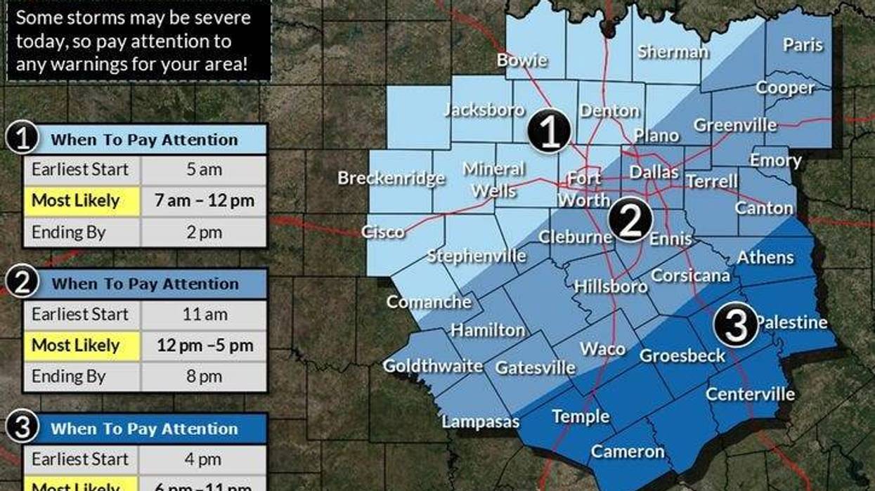
Severe Thunderstorm Watches were in effect to the northwest of Dallas-Fort Worth Wednesday morning, while Flood Watches were in effect north of the area through the evening.
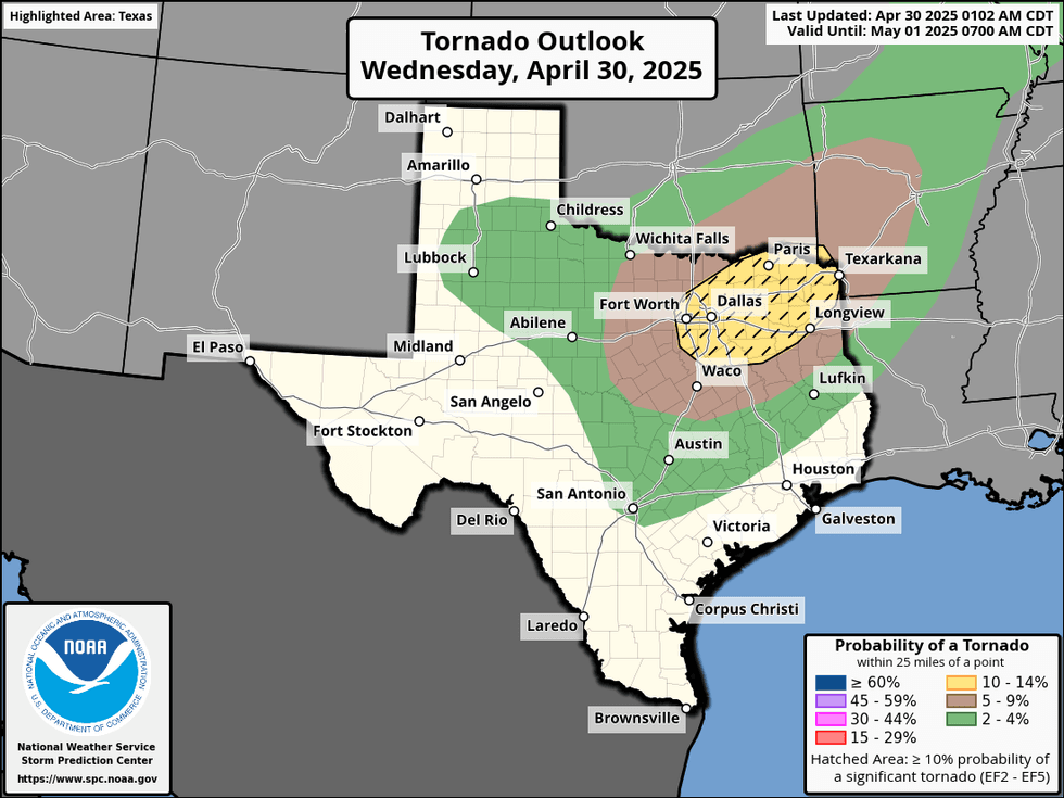
A large area of showers and thunderstorms developed between Abilene and Wichita Falls on Wednesday, and is expected to arrive in North Texas' western counties by mid-to-late morning, and across the rest of the Dallas-Fort Worth area through mid-afternoon. Threats include large hail, damaging winds, and isolated tornadoes.
A new storm or tornado watch will likely be issued, encompassing all of North Texas. While the morning commute should be unaffected, the afternoon commute may be impacted, especially for those heading south or east of the Dallas-Fort Worth area. Afternoon highs will struggle to reach 80 degrees.
Storms will move out Wednesday evening, followed by fog rolling in Thursday morning, with temperatures ranging from 56 to 61 degrees. There will be a break in the storms on Thursday, with some afternoon sunshine, and readings topping out in the mid-80s.
 NOAA
NOAA
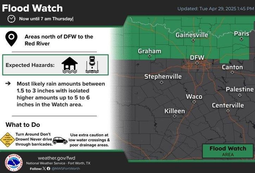 A Flood Watch is in effect for parts of North Texas through Thursday morning.National Weather Service
The next weather maker arrives on Friday, in the form of a cold front, bringing more showers and storms, potentially strong to severe, especially south of the Dallas-Fort Worth area. Afternoon highs will be in the low 80s.
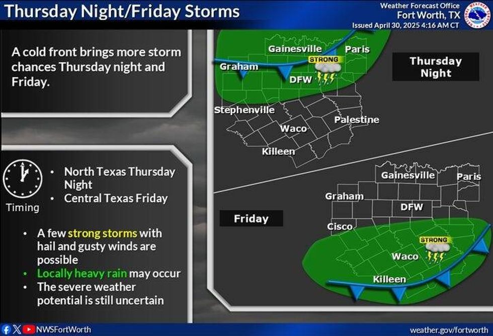 North Texas forecast for Thursday and Friday, May 1-2, 2025.National Weather Service
Dryer air will move into North Texas this weekend, pushing rain chances to our south, with afternoon highs reaching the mid-70s on Saturday and near 80 degrees on Sunday.
A slow-moving weather pattern will develop by the middle of next week, bringing our best chances for showers and storms.
7-Day Headlines
DFW hit 83 degrees on Tuesday.
Weather watches and severe storms on Wednesday from 9 a.m. to 3 p.m.
Threats: Large hail, damaging wind, isolated tornadoes.
A break in the weather on Thursday.
More strong to severe storms Friday.
Cooler temperatures this weekend. Isolated showers south.
*Tuesday Rain: 0.00"; Tuesday High: 83 Low: 71
*Wednesday's Averages: High: 79; Low: 59
*Record high: 95 (1928): Record low: 35 (1903)
_________________________________________________________
*April Rain: 2.82"; Deficit: 0.27"
*2025 Rain: 11.53"; Deficit: 0.15"
*Sunrise: 6:40am; Sunset: 8:10pm
_________________________________________________________
Wednesday: Cloudy and stormy. Areas of severe weather between 9 a.m. and 3 p.m. Threats: Large hail, damaging wind, isolated tornadoes, flooding (north). High: Mid 70s. Wind: SE 15-25 mph.
Wednesday night: Calming down. Watch out for the morning fog. Cooler. Low: 56-61. South 10-20 mph.
Thursday: Morning clouds/fog, afternoon sun. High: Mid 80s. Wind: SW 5-10 mph.
Friday: Scattered showers and storms, some severe. Afternoon cold front. High: Low 80s.
Saturday: Mostly to partly cloudy and cooler. Scattered showers south of DFW. High: Mid 70s.
Sunday: Partly cloudy and pleasant. High: Near 80.
Monday: Partly cloudy and nice. High: Low 80s.
Tuesday: Storm chances return. High: Low 80s.
LISTEN on the Audacy App
Tell your Smart Speaker to "PLAY 1080 KRLD"
Follow us on Facebook | Twitter | Instagram | YouTube