
WAIT… WHAT WAS THAT ON MY WINDSHIELD?
Something strange happened when I got in my car at 3:15 this morning up in Collin County… there was DEW on my windshield!
Believe it or not, that’s the first moisture I’ve seen at my place in almost SEVEN WEEKS!
Some of you lucky folks actually saw some rain yesterday, especially east of McKinney and into Dallas County. And guess what? That same general area has another shot at some rain today!
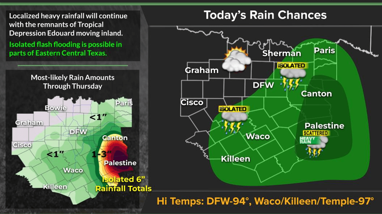
I’ve been tracking the remnants of Tropical Storm Edouard, and while it’s getting harder to find a well-defined center of circulation, it appears to be just south of I-20 and south of Canton and is now moving very little.
A little drift to the west would certainly be nice!
THE RAINFALL:
There’s a lot of rain occurring along and east/south of the leftover circulation, which is why Flood Watches remain in effect, mainly east of I-45 and south of I-20.
I think most of the heavier rain will remain east and south of the DFW area through the morning hours. But as we move into the afternoon and early evening, some of that moisture could drift westward into Collin, Dallas and Ellis counties.
And there’s another area I’ll be watching closely…
Some data is showing the possibility of showers developing west of Fort Worth, near the Ross Fire area. That would be VERY welcome! We definitely don't need the lightning, but those folks desperately need the rain.
After sunset, much of the shower activity should diminish. However, if you live near that leftover circulation, showers could continue overnight tonight and into Thursday morning.
LOOKING AHEAD TO FRIDAY:
A lot depends on exactly where that circulation settles. Right now, it looks like it could come to a screeching halt and end up just south of the Dallas-Fort Worth area on Friday.
If it stays close enough, I think we could see scattered showers and isolated thunderstorms across more of North Texas Friday afternoon and evening.
I can't tell you exactly where the rain will fall just yet, but the coverage should spread a little farther west on Friday. Saturday looks like most of the rain will remain south of us, although a few renegade showers or storms could still pop up.
Then… unfortunately…
HOT AND DRY RETURNS!
After Saturday, the heat builds back in for the remainder of the holiday weekend and continues into at least the middle to end of next week.
Cloud cover will help hold temperatures down today. I think we’ll struggle to get much above 90° at DFW Airport, while areas farther west toward Weatherford, Abilene and Wichita Falls could be well into the triple digits.
After Saturday, temperatures will once again flirt with 100°+ across North Texas, and that heat looks likely to stick around through much of next week.
I HOPE YOU SEE SOME RAIN!
And if you do… THROW A PARTY!
I’m Meteorologist Dan Bruno in the KRLD Weather Center.
Have a blessed day, everyone, and enjoy the weather when you can… because it’s the only weather you’ve got!
7-Day Headlines:
- DFW Airport hit 100 degrees on Wednesday
- 39 triples this summer
- 49 days with no measurable rain at DFW
- Watching the remnants of Edouard!
- Scattered showers and storms today and Friday
- Cooler Thursday
- Heating back up for Labor Day weekend
- Download our AUDACY app! Listen to KRLD LIVE at home or at work
Almanac:
- Yest Rain: 0.00”; Yest High: 100; Low: 78
- Today’s Averages: High: 92; Low: 73
- Record high: 109 (2000); Record low 60 (1974)
- September rain: 0.00”; Deficit: <0.20”>
- 2026 Rain: 22.61”; Snow: 2.4”; Deficit: <2.14”>
- Sunrise: 7:05am; Sunset: 7:49pm
Forecast:
Thursday: Mostly cloudy, breezy, and cooler. Scattered showers and isolated storms. Not everyone will see rain. GOOD LUCK! High: Near 90, hotter west of FTW. Wind: SE 10-20 mph.
Thursday night: Mostly cloudy, breezy, mild and humid. Showers east of south of DFW. Low: Mid to upper 70s. Wind: SE 10-20 mph.
Friday: Partly to mostly cloudy, breezy, and warm. Higher humidity. Scattered showers and isolated thunderstorms. High: Mid 90s. Wind: South 5-10 mph.
Saturday and Sunday: Mostly sunny and humid. A few afternoon showers EAST of DFW. Highs: Upper 90s Heat index: Near 105.
Labor Day: Mostly sunny and hot. High: Near 101.
Tuesday and Wednesday: Mostly sunny, continued hot. High: Near 101.
LISTEN on the Audacy App
Tell your Smart Speaker to "PLAY 1080 KRLD"
Sign Up to receive our KRLD Insider Newsletter for more news
Follow us on Facebook | Twitter | Instagram | YouTube