
A relatively stagnant weather pattern is expected to prevail during the initial days of this week, although some precipitation chances are anticipated in the 7-Day forecast. I will address these inquiries and provide further insights in this daily forecast discussion.
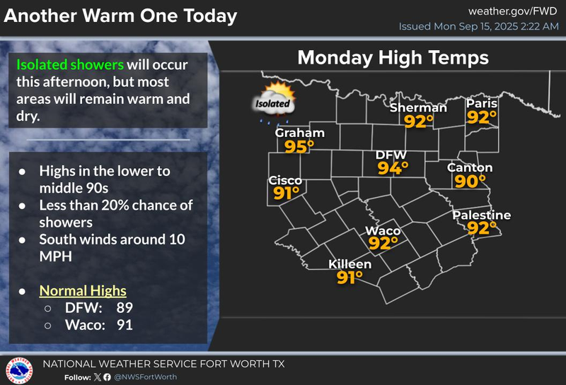
Happy Monday! I hope everyone had a pleasant weekend. Personally, I had an enjoyable weekend, despite experiencing some intense moments while watching college and NFL football. As we return to our daily routines, the first few days of this week are expected to be relatively dry, with only a slight chance of a late-day shower this afternoon and again tomorrow afternoon. However, most areas will remain dry. Afternoon highs will reach the mid-90s.
A strong high-pressure system in the upper levels will continue to dominate our weather through Wednesday. Nevertheless, this ridge is expected to break down by Thursday and Friday, leading to improved precipitation chances in the area. Furthermore, storms will form to our north and northwest late Wednesday and again late Thursday, potentially bringing some activity to the region. If these storms persist, we may experience some disturbances during the overnight hours early Thursday and again early Friday morning. Temperatures will be slightly cooler by the end of the week due to increased cloud cover, with afternoon highs reaching the 90-degree mark in some areas.
This upper-level ridge will attempt to rebuild across the area over the weekend, with highs returning to the low 90s and minimal precipitation forecasted. Fall officially arrives a week from today, marking the beginning of another pattern change.
Currently, the timing of our next significant cold front appears to be slower than initially anticipated, with its arrival now expected during the early to middle parts of next week. This front will bring cooler temperatures and improved precipitation chances.
I will continue to analyze the data and provide updates throughout the week regarding the timing, coverage, and temperature trends. Have a great day today and enjoy the weather when you can, it's the only weather you've got!
FORECAST:
Today: **Air Quality Alert** Sunny and warm. An isolated late-day shower. High: Mid 90s. Wind: SSE 5-10 mph.
Tonight: Mostly clear and mild. Low: Low to mid 70s. Wind: South 5-10 mph.
Tuesday: Sunny and warm. High: Low to mid 90s. Wind: SSE 5-10 mph.
Wednesday: Partly cloudy and warm. Scattered showers and storms towards midnight. High: Low to mid 90s.
Thursday: Partly cloudy, a bit cooler. Scattered showers and storms. High: Near 90.
Friday: Partly cloudy and warm. Scattered showers and storms. High: Near 90.
Saturday: Partly cloudy and warm. Isolated showers and storms. High: Near 90.
Sunday: Partly cloudy and warm. Isolated showers and storms. High: Near 90.
Yesterday’s high: 94; Low: 73
Average high: 89; Average low: 69
2025 Rainfall: 27.74”; Surplus: 1.74”
LISTEN on the Audacy App
Tell your Smart Speaker to "PLAY 1080 KRLD"
Sign Up to receive our KRLD Insider Newsletter for more news
Follow us on Facebook | Twitter | Instagram | YouTube