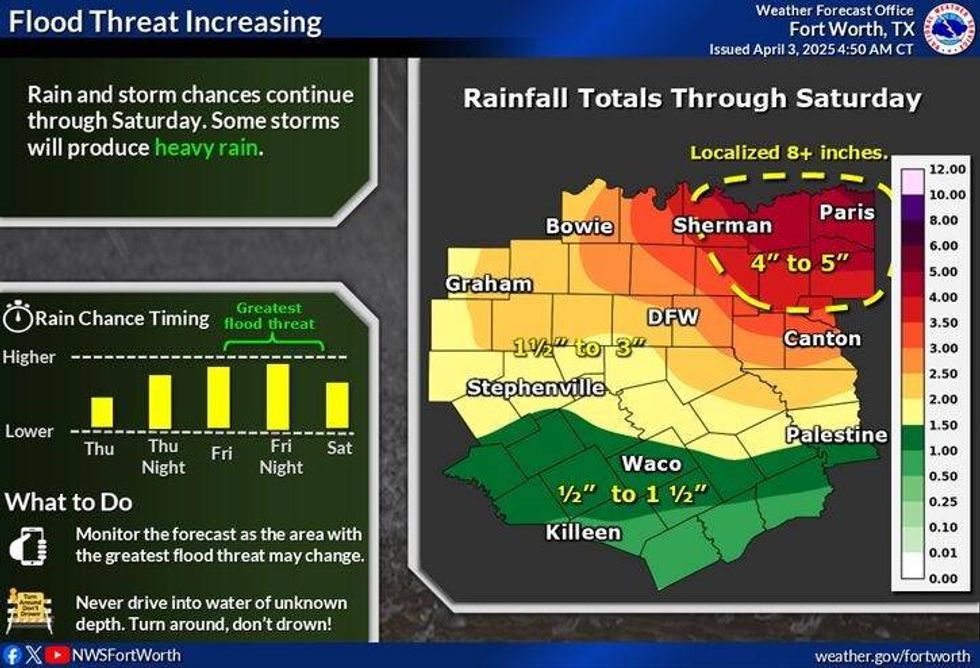
A powerful storm system will impact North Texas from Thursday morning through Saturday, producing strong to severe thunderstorms and a flooding threat in some areas. The primary threats associated with these storms are large hail, damaging winds, and isolated tornadoes. Rainfall totals are expected to range from 2-5 inches, with isolated areas to the north and northwest potentially receiving higher totals.
A significant storm system affected the Red River region and the Big Country near Abilene on Thursday morning. A cold front is positioned to the south, just north of the Waco to Brownwood line. The combination of this front and a strong upper-level disturbance moving in from the west will lead to additional showers and isolated severe thunderstorms through the noon hour. Areas along and north of Interstate 20 are at the greatest risk for large hail, although it is essential to note that many locations will not experience hail. This system will move east of the region after the noon hour, resulting in a relatively quiet remainder of the day. Afternoon highs will range from 65-80 degrees, depending on the location relative to the front.
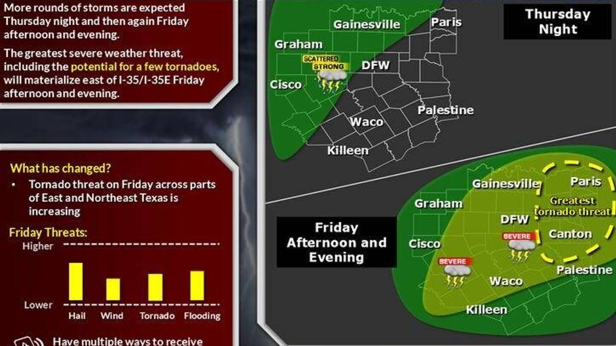
The next system will move into the region from the west late Thursday, producing strong to severe thunderstorms, primarily west and northwest of the Dallas-Fort Worth area. A few storms may extend into the area by daybreak, although most activity will remain north and west. Low temperatures will range from 55-70 degrees.
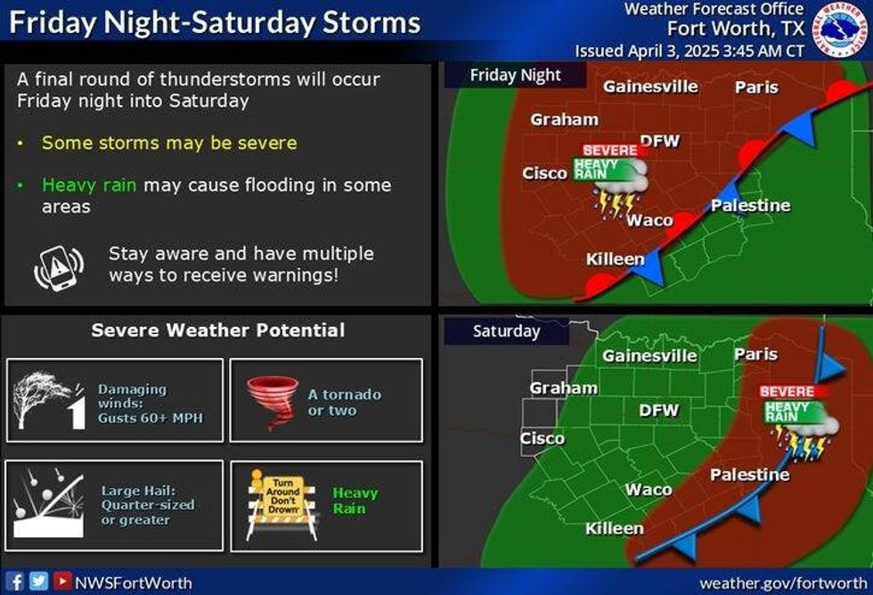
On Friday, a few scattered showers are possible, with afternoon highs ranging from 65-80 degrees. Widespread shower and thunderstorm activity, including severe storms, is expected to develop late in the afternoon and evening. All modes of severe weather are possible. The storm system will shift east overnight, with more widespread shower and thunderstorm activity developing to the west and southwest.
 National Weather Service
On Saturday, the storm system will slowly move across the region, producing waves of heavy rain, hail, and thunder. Rainfall totals will exceed 2 inches in some areas, potentially leading to flooding. Afternoon highs will decrease behind the cold front, reaching the upper 40s by evening.
On Sunday morning, skies will be cloudy, with some shower activity and temperatures ranging from 38-44 degrees across North Texas. Wind chills will be near freezing, making for a remarkably cold start to April. Skies will gradually clear from west to east by afternoon and early evening, with afternoon highs reaching the upper 40s to mid-50s, depending on the timing of sunshine return. Winds will relax by evening.
On Monday morning, clear skies and light winds are expected, with low temperatures ranging from 35-40 degrees. It will be essential to protect plants from the cold. Sunny conditions will prevail, with highs near 70 by afternoon. Temperatures will gradually warm to the mid-70s on Tuesday and Wednesday, accompanied by plenty of sunshine, making for beautifully cool weather ahead.
 National Weather Service
7-Day Headlines
DFW reached 79 degrees on Wednesday. 0.15" of rain.
Morning severe storms, storm watch until 8 a.m. Threat: Large hail.
More strong to severe storms tonight into Saturday morning.
Threats: Hail, wind and isolated tornadoes.
Waves of heavy rain Friday into Saturday.
Rain totals: 2.00" to 5.00".
Much cooler late Saturday through Monday.
*Wednesday Rain: 0.00"; Wednesday High: 79 Low: 63
*Thursday's Averages: High: 74; Low: 52
*Record high: 95 (1989): Record low: 30 (1987)
_________________________________________________________
*April Rain: 0.15"; Deficit:
*2025 Rain: 8.86"; Surplus: 0.07"
*Sunrise: 7:12am; Sunset: 7:51pm
_________________________________________________________
Thursday: ** Severe thunderstorm watch until 8 a.m. ** Scattered morning severe storms, then mostly cloudy, breezy, and mild. Threats: Large hail, damaging wind, isolated tornado. Highs: 65-75. Wind: NE 10-20 mph.
Thursday night: Cloudy and muggy. Scattered severe storms, mainly west and NW of DFW. Threats: Large hail, damaging wind, and isolated tornadoes. Low: Mid to upper 50s. NE 5-10 mph.
Friday: Morning showers and storms, a break in the afternoon, more severe storms late. Threats: Large hail, wind, and isolated tornadoes. High: 60-75. Wind: Variable 10-20 mph.
Saturday: Showers and storms likely with heavy rain. Isolated flooding. Turning windy and MUCH colder. High: 60s early, falling into the 40s by evening.
Sunday: Morning clouds, clearing by afternoon. Windy and chilly! High: Low to mid-50s.
Monday: Mostly sunny and perfect. High: Near 70.
Tuesday: Mostly sunny and comfortable. High: Mid-70s.
 National Weather Service
LISTEN on the Audacy App
Tell your Smart Speaker to "PLAY 1080 KRLD"
Sign Up to receive our KRLD Insider Newsletter for more news
Follow us on Facebook | Twitter | Instagram | YouTube