


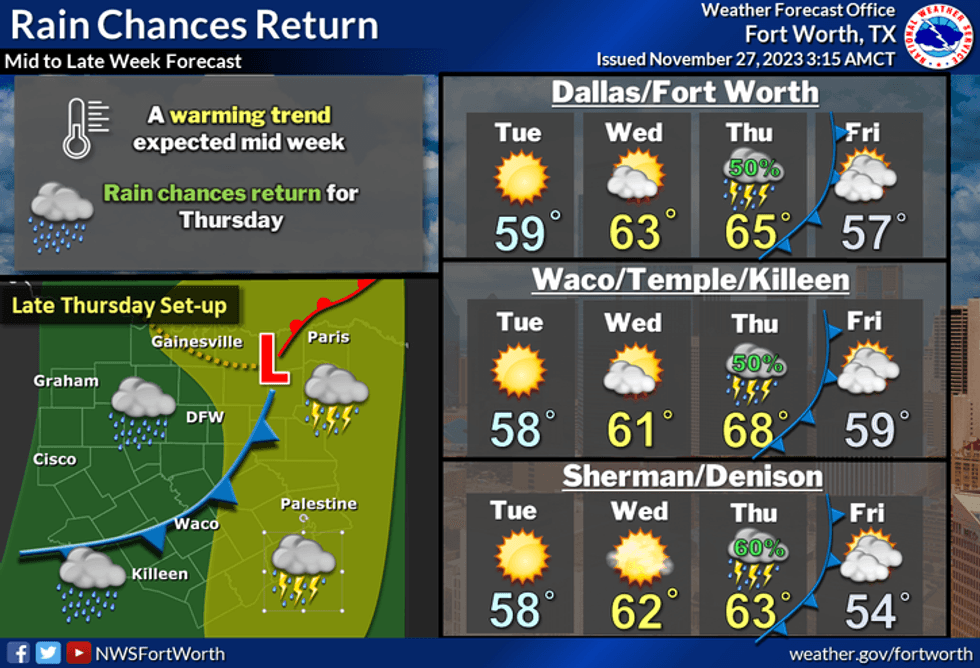
The weather over the next seven days will stay on the cool side, with our next rain chance arriving on Thursday.
Temperatures were below freezing across parts of North Texas on Monday morning, but as of 6 a.m. DFW Airport had not officially hit the freezing mark. We'll see passing high clouds on Monday as we remain on the cool side. Afternoon highs will only reach the low to mid-50s with a light north wind. There will be high clouds and it will be chilly again Monday night with morning lows in the mid to upper 30s.
Tuesday looks nice with slightly warmer temperatures. Afternoon highs will top out near 60 degrees as winds slowly return from the south.
Look for increasing clouds on Wednesday, and breezy and seasonable temps. Afternoon highs will reach the low 60s with a south wind at 10-20 mph. There is a slight chance for showers towards midnight.
A pretty strong upper-level disturbance will cross the area on Thursday bringing a chance of rain back to the area. The heaviest rainfall totals will be east of the Dallas-Fort Worth area. Afternoon highs will reach the low to mid-60s.
A weak cold front will move through the area early Friday morning, but it won't have a lot of cold air behind it. Afternoon highs will top out in the mid to upper 50s.
As of Monday morning, the weekend looks fairly nice with a slight chance for a shower on Saturday. Afternoon highs on both days will top out in the low 60s, which is seasonable for this time of the year.
 Rain chances return to North Texas on Thursday.National Weather Service
7-Day Headlines
* DFW Airport reached 52 degrees on Sunday.
* A lot of areas dropped below freezing on Monday morning.
* Another cool day on Monday.
* A midweek warm-up.
* Rain chances return on Thursday. Heaviest east of DFW.
* Seasonable temperatures this weekend. Slight rain chance on Saturday.
_____________________________________________________
*Sunday Rain: 0.00"; Sunday High: 52; Low: 35
*Monday's Averages: High: 63; Low: 43
*Record high: 82 (1905); Record low: 21 (1938)
_________________________________________________________
*November rain: 0.41"; Deficit: < 1.82">
*2023 Rain: 25.70"; Deficit: < 8.17">
*Sunrise: 7:09am; Sunset: 5:22pm
_________________________________________________________
Monday: A chilly start, a cool end to the day with passing high clouds. High: Low 50s. Wind: NE 5 mph.
Monday night: High clouds and chilly. Low: Mid to upper 30s. Wind: NE 5 mph.
Tuesday: Mostly sunny and cool. High: Near 60. Wind: South 5 mph.
Wednesday: Increasing clouds, breezy and seasonable. A slight chance of showers by late evening. High: Low 60s.
Thursday: Mostly cloudy and cool. Scattered showers and isolated storms. Greatest coverage east of DFW. High: Mid 60s.
Friday: Partly cloudy, a bit cooler. High: Mid to upper 50s.
Saturday: Mostly cloudy and cool. A slight chance of showers. High: Low 60s.
Sunday: Partly cloudy and seasonable. High: Low 60s.
LISTEN on the Audacy App
Tell your Smart Speaker to "PLAY 1080 KRLD"
Sign Up to receive our KRLD Insider Newsletter for more news
Follow us on Facebook | Twitter | Instagram | YouTube


