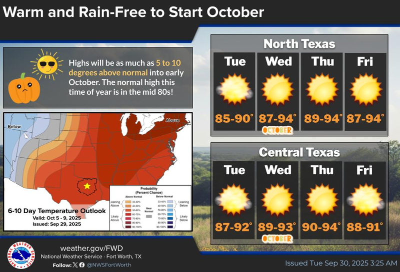

The final day of September is expected to bring cloudy skies and scattered sprinkles, while the first ten days of October will be characterized by above-average temperatures and a lack of precipitation in the forecast.
Patience is indeed a virtue, as we have been experiencing above-average temperatures and below-average precipitation throughout the last week of September, a trend that will persist for at least the first third of October.
This morning, we are waking up to a mostly cloudy sky, with temperatures ranging from the mid-60s to mid-70s. The cloud cover is providing insulation for our air at the surface. Additionally, I am observing a few light showers on radar, although most of these are not reaching the ground. These clouds will clear out from west to east throughout the day, with afternoon highs reaching the upper 80s once again. The average high temperature has now decreased to 84 degrees, and we can expect it to dip to 72 degrees by the end of October.
A mid-level ridge of high pressure will begin to build across the state this week and into the weekend, as well as the first part of next week. This will maintain temperatures well above average, keep precipitation at bay, and ensure an abundance of sunshine. Afternoon highs will be slightly above 90 degrees from tomorrow through Friday, nearing 90 degrees over the weekend and into early next week.
A weak cold front will approach our area late Monday and Tuesday, resulting in a slight drop in temperatures. However, we will have to wait for the second, stronger front to arrive the following weekend, which will bring noticeably cooler air and the chance of precipitation back to the forecast. Unfortunately, we will have to wait almost two weeks for that front to arrive.
That concludes my weather update for this Tuesday morning. I would like to extend my gratitude to Bruce Bochy for his outstanding tenure with the Texas Rangers. We all wish him and his family the best of luck, and I am confident that he will enjoy the weather whenever possible, as it is the only weather he's got!
7-Day Headlines:
DFW hit 87 degrees on Monday.
Morning clouds/sprinkles, afternoon sun.
Mid-level high pressure dominates through the weekend.
Above average temperatures, below average rainfall.
No major change for a while.
Cooler weather change in 10 to 12 days
*Yest Rain: 0.00”; Yest High: 87 Low: 67
*Today’s Averages: High: 84; Low: 63
*Record high: 98 (1953, 1977); Record low: 43 (1984)
*September Rain: 1.11”; Deficit:
*2025 Rain: 28.16”; Surplus: 0.97”
*Sunrise: 7:23am; Sunset: 7:12pm
Tuesday: *Air Quality Alert* Morning clouds/sprinkles, afternoon sunshine. High: Upper 80s. Wind: North 5 mph.
Tuesday night: Clear and pleasant. Mild. Low: 63-71. Wind: North 5 mph.
Wednesday: Sunny and warm. High: Low 90s. Wind: East 5 mph.
Thursday and Friday: Mostly sunny and warm. High: Low 90s.
Weekend: Partly cloudy and warm. High: Near 90.
Monday: More of the same. Sunny and warm. High: Upper 80s.
LISTEN on the Audacy App
Tell your Smart Speaker to "PLAY 1080 KRLD"
Sign Up to receive our KRLD Insider Newsletter for more news
Follow us on Facebook | Twitter | Instagram | YouTube