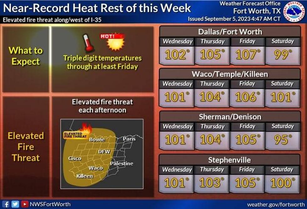
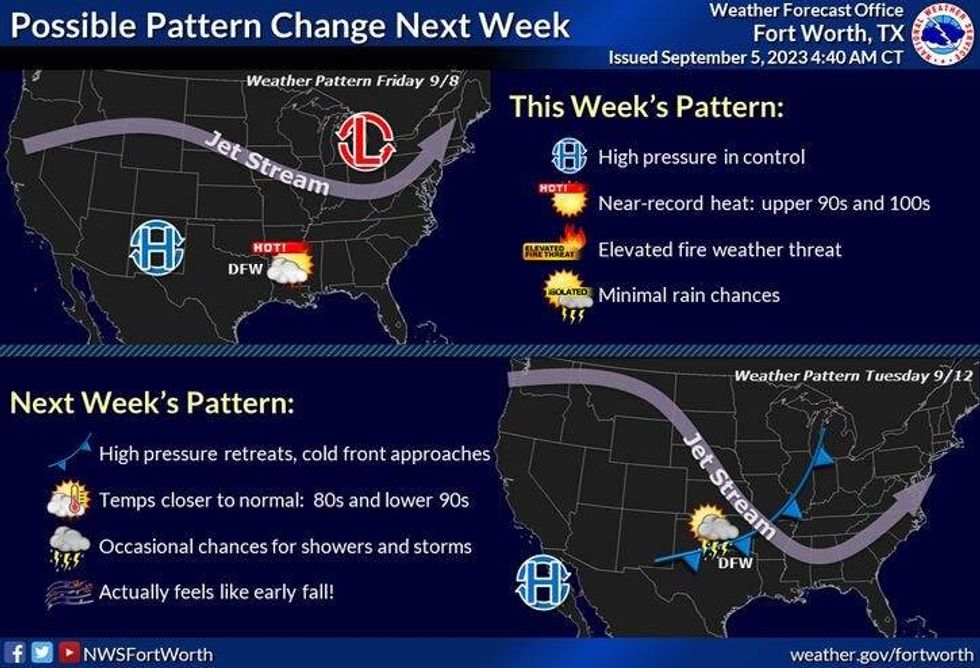
Triple digit temperatures are back across north Texas through the rest of this week, with heat advisories in effect at least through tomorrow. Plus, record highs will be broken Thursday and Friday. This weekend will be slightly cooler with a few scattered showers and storms around, and by early next week, a significant pattern change may arrive with welcome rain and much cooler temperatures.
We're starting Tuesday with temperature readings near 80° under a fair sky. There's also a few scattered showers and storms well to the west of the Dallas-Fort Worth area. These will stay out there and not effect us today.
Heat Advisories are in effect today and tomorrow with afternoon highs close to 103°. There's also a very slight chance for a late day shower storm on Wednesday, especially north of DFW, as a weak cold front settles along the Red River.
 National Weather Service - Fort Worth
Thursday and Friday will be the hottest days this week with possible Excessive Heat Warnings across the area. Thursday's high will be near 105°, Friday's High 107°. If we reach these numbers, which I think we will, new record highs will be set.
We'll be a little bit cooler this weekend with a slight chance for some late day showers and storms. Afternoon highs will only reach the upper 90s.
By early next week, I'm going to be keeping my eye on a possible cold front that may bring increasing rain chances to much of north Texas, as well as much cooler temperatures.
 National Weather Service - Fort Worth
*Yest Rain: 0.00"; Yest High: 100; Low: 77
*Today's Averages: High: 92; Low: 72
*Record high: 104 (1913): Record low: 55 (1974)
*September rain: 0.20"; Deficit: 0.18"
*2023 Rain: 15.03"; Deficit: 9.90"
*Sunrise: 7:05am; Sunset: 7:48pm
Today: *Heat Advisory* Mostly sunny, breezy and hot. Grass fire danger. High: 102. Heat index: 105+. Wind: South 10-20 mph.
Tonight: Clear, breezy and warm. Low: Near 80. Wind: South 10-20 mph.
Tomorrow: *Heat Advisory* Mostly sunny, breezy and hot. Isolated late afternoon and evening showers and storms. High: 103. Heat index: 105+. Wind: SSW 10-15 mph.

Thursday: Mostly sunny and hot. Record (104) high likely. High: 105.
Friday: Partly cloudy and hot. Isolated late day showers and storms. Record (100) high likely. High: 107.
Weekend: Partly cloudy, not as hot. Isolated late day showers and storms. High: Upper 90s.
Monday: Partly cloudy and cooler. Scattered showers and storms. High: Low to mid 90s.
LISTEN on the Audacy App
Tell your Smart Speaker to "PLAY 1080 KRLD"
Sign Up to receive our KRLD Insider Newsletter for more news
Follow us on Facebook | Twitter | Instagram | YouTube