


An unsettled weather pattern heads into North Texas for at least the next week, bringing waves of showers and thunderstorms, and seasonable temperatures.
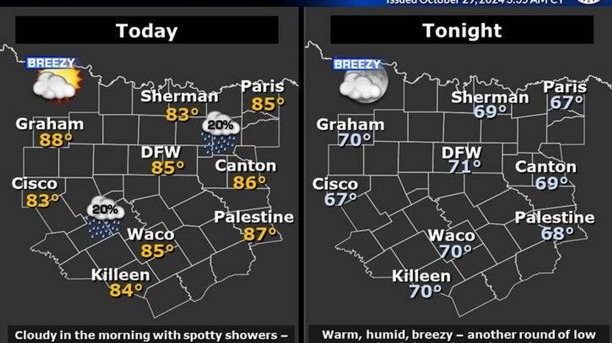
Tuesday began with a cloudy sky and a few isolated showers dotting the area. Temperatures were in the low to mid-70s. There will be breaks in the clouds, wind, and warm temperatures with highs and the low to mid-80s. No rain is in the forecast.
More of the same for Wednesday. Morning clouds, a few morning showers, with peaks of afternoon sunshine. Afternoon highs will reach the low to mid-80s with breezy conditions.
Things start to change late Wednesday evening into early Thursday before the morning commute. A pretty decent cold front will move into the area producing scattered showers and storms. This area of storms will form about 50-70 miles to the west and northwest by Wednesday evening. This area of storms will intensify and increase in coverage as it pushes south and east overnight Wednesday. Some of these storms may become severe. Threats: Hail and damaging wind. The heaviest rain totals will be east and southeast of DFW.
This front clears out Thursday morning. It will become sunny, breezy, cooler, with lower humidity. Afternoon highs will reach the low to mid-70s.
Most of Friday is relatively dry, however, this front will lift back to the north by evening producing a few scattered showers with it. Afternoon highs Friday will reach the mid-70s.
The next weather system will be diving into California this weekend and exiting the Rockies early next week. This will produce a couple of waves of showers and storms through the weekend.
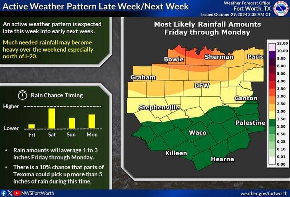 North Texas rainfall amountsNational Weather Service
7-Day Headlines
* DFW Airport reached 86 on Monday.
* A few showers before noon on Tuesday and Wednesday.
* Above average temperatures and very windy through Wednesday.
* Late Wednesday a cold front brings scattered strong storms for some.
* Seasonable temperatures are coming.
* Scattered showers and storms late Friday - Monday.
_____________________________________________________
*Monday Rain: 0.00"; Monday High: 86; Low: 72
*Tuesday's Averages: High: 73; Low: 52
*Record high: 92 (1937); Record low: 31 (1910)
________________________________________________________
*October Rain: 0.00"; Deficit:
*2024 Rain: 33.94"; Surplus: 2.73"
*Sunrise: 7:44am; Sunset: 6:39pm
________________________________________________________
Tuesday: Morning showers and clouds; it is partly cloudy this afternoon. Windy, muggy, and warm. High: Low to mid-80s. Wind: South 15-25, G35 mph.
Tuesday night: Increasing low clouds late. Low: Low to mid-70s. Wind: South 15-25, G30 mph.
Wednesday: Morning showers and clouds; it will be partly cloudy this afternoon. Windy, muggy, and warm. High: Low to mid-80s. Wind: South 15-25, G35 mph.
Wednesday night: Cold front arrives. Scattered showers and storms. Isolated severe. Threats: Isolated hail and damaging wind. Low: 58-72.
Thursday: Early morning showers, then a slow decrease in clouds, breezy and cooler. High: Low to mid-70s.
Friday: Increasing clouds and seasonable. A warm front brings more rain by evening. High: Mid-70s.
Weekend: Mostly cloudy, with scattered showers and storms. Highs: Mid-70s.
Monday: Mostly cloudy, scattered showers and storms. High: Mid-70s.
LISTEN on the Audacy App
Tell your Smart Speaker to "PLAY 1080 KRLD"
Sign Up to receive our KRLD Insider Newsletter for more news
Follow us on Facebook | Twitter | Instagram | YouTube


