
Good Tuesday morning, everyone! I hope you had a great Monday!
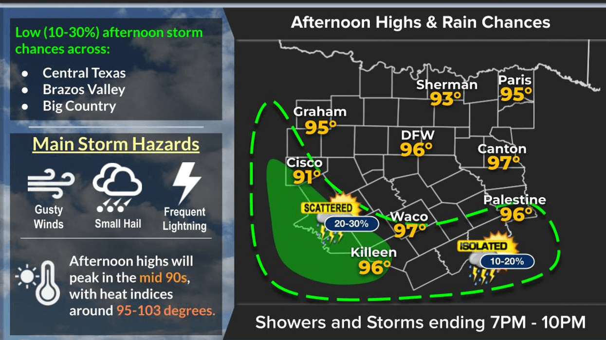
Some welcome rain fell across parts of North Texas yesterday evening! The 67-consecutive-day streak with no measurable rainfall at DFW is finally over — although DFW measured a whopping 0.01 inches. I sure wish we had gotten a LOT more, but hey... we'll take what we can get!
Unfortunately, rain chances are now gone for a while. Temperatures will remain above average for the next 7 days, but the morning lows will drop significantly toward the end of the week.
Fall officially arrives later this afternoon/evening after 7 p.m., but Mother Nature apparently didn't get the memo. It certainly won't feel much like fall around here just yet.
A weak cold front has slipped through the area, and for the next several days we're looking at:
Today: Mid-90s
Humidity gradually decreases
Tonight: Lots of 60s, with some low 70s
Wednesday–Friday: Mid-90s each afternoon
Morning lows: Generally mid-60s to low 70s
High pressure centered over the Tennessee River Valley will eventually turn our winds back around to the south by the end of the week, helping keep those temperatures in the mid-90s.
The opening weekend of the State Fair of Texas is shaping up to be a pretty toasty one! Expect afternoon highs in the mid-90s, with morning lows in the low to mid-70s.
I'm also watching our next weather system, but it's still about 6–7 days away. Toward the end of the weekend and into early next week, we could see some showers and thunderstorms across parts of North Texas.
We'll have to see if that next front actually makes it through the area. The extended-range data is hinting at a stronger cold front by the middle of next week, which could finally bring us a more noticeable taste of fall.
So, yes... fall is here, but it may take another couple of weeks before it actually feels like fall around North Texas!
Have a great Tuesday, everyone, and enjoy the weather when you can — it's the only weather you've got!
7-Day Headlines:
- DFW Airport hit 96 degrees on Thursday
- 52 triples this summer
- 67 days with no measurable rain at DFW
- Heat Advisories gone
- More rain chances today; weak cold front
- Slightly cooler this week, temps remaining above average
- Fall starts Tuesday
- Download our AUDACY app! Listen to KRLD LIVE at home or at work
Almanac:
- Yest Rain: 0.00”; Yest High: 96; Low: 79
- Today’s Averages: High: 87; Low: 67
- Record high: 99 (1956, 2005); Record low 45 (1983)
- September rain: 0.00”; Deficit: <1.92”>
- 2026 Rain: 22.61”; Snow: 2.4”; Deficit: <3.86”>
- Sunrise: 7:16am; Sunset: 7:25pm
Forecast:
Monday: Partly cloudy and hot.Scattered afternoon and evening showers and storms. High: Mid 90s. Wind: Shifting NE 5-10 mph.
Monday night: A few evening showers, then partly cloudy and slightly cooler. Low: Low to mid 70s. Wind: NE 5-10 mph.
Tuesday: Partly cloudy, slightly cooler. Isolated afternoon and evening showers and storms. High: Low 90s. Wind: NE 10-20 mph.
Wednesday: Partly cloudy and warm. High: Low 90s.
Thursday: Partly cloudy and hot. High: Mid 90s.
Friday: Opening Day of The State Fair of Texas. Partly cloudy and hot. High: Mid 90s.
Weekend: Partly cloudy, continued hot. Slight rain chance on Sunday. Highs: Mid 90s.
LISTEN on the Audacy App
Tell your Smart Speaker to "PLAY 1080 KRLD"
Sign Up to receive our KRLD Insider Newsletter for more news
Follow us on Facebook | Twitter | Instagram | YouTube