




**A COOL START TO THE WEEK, BUT WARMER WEATHER IS ON THE WAY!**
Everybody got in on at least some much-needed rainfall over the weekend! Meanwhile, rather chilly temperatures for this time of year have settled into North Texas. Those cooler temperatures will stick around for the next couple of days before we warm back up to at or above seasonal averages by the middle to end of the week. Our next rain chance looks pretty slim and is currently expected next weekend.
Good morning, everyone! Welcome to Monday… YUCK!
**CHILLY START TO YOUR MONDAY**
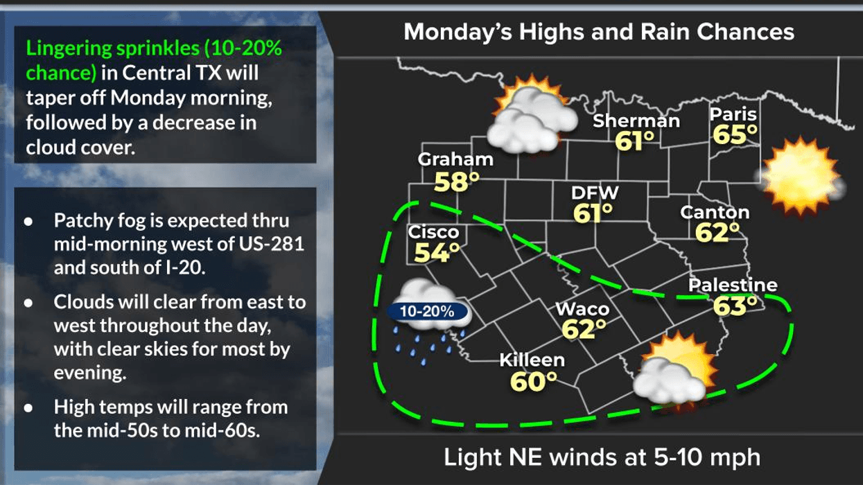
Temperatures are hovering in the low to mid 40s this morning under considerable cloudiness. There could even be a few areas of patchy drizzle across the region during your morning commute.
Radar is showing a few showers west of I-35W, stretching from just west of Gainesville through Decatur and Weatherford and out toward Mineral Wells.
These showers are associated with the upper-level storm system that brought most of North Texas anywhere from ½ inch to 2½ inches of rainfall, with some higher totals closer to the Red River Valley. A few sprinkles may linger through the first half of today.
**CLOUDS STICK AROUND, THEN CLEARING!**
Temperatures won't be going anywhere in a hurry today, and neither will those clouds! Skies will gradually clear from west to east later this afternoon. High temperatures will range from around 50 degrees east of the Metroplex to the mid and upper 50s elsewhere.
**WATCH FOR PATCHY FOG TONIGHT!**
Temperatures will fall back into the 40s tonight under clearing skies. As winds calm down, some patchy fog could develop. Keep that in mind if you're heading to work or school early Tuesday morning.
**BEAUTIFUL WEATHER RETURNS TUESDAY!**
We'll have sunshine back in full force Tuesday with afternoon highs climbing into the low to mid 60s.
South winds return Wednesday, and that means our temperatures will continue to climb!
**A WARMING TREND THROUGH THE END OF THE WEEK**
- Wednesday: Temperatures warm into the upper 60s.- Thursday & Friday: More sunshine and highs generally in the upper 60s.- Saturday: South winds really pick up ahead of our next upper-level storm system. Highs climb into the low to mid 70s!
**OUR NEXT RAIN CHANCE?**
A few showers could develop late Saturday and continue into Sunday. It's still too early to determine exactly how much rain we might receive, but right now this system doesn't look nearly as impressive as the one that just moved through.
Most of the stronger upper-level dynamics appear likely to remain too far away from North Texas to produce another widespread soaking rain event.
Temperatures will cool back into the mid to upper 60s by next Sunday.
**AND DON'T FORGET… THANKSGIVING WEEK IS JUST AROUND THE CORNER!**
I'll have more on that forecast as we move through the week!
I appreciate everyone who follows my page. Please LIKE and SHARE to help keep North Texans informed, prepared, and weather aware!
Have a wonderful start to your new workweek, everyone. Make it a great day!
7-Day Headlines:
- DFW Airport hit 51 degrees on Sunday. 0.53” of rain at DFW.
- Clouds move out today
- Tuesday morning fog
- Warming trend starts Tuesday, mornings will be cool
- 70s return Thursday - Sunday
- Rain chances return late Sunday into early next week
- Download our AUDACY app! Listen to KRLD LIVE at home or at work
Almanac:
- Yest Rain: 0.00”; Yest High: 51; Low: 45
- Today’s Averages: High: 66; Low: 46
- Record high: 87 (2016); Record low 24 (1920, 1932, 1997)
- November rain: 0.54”; Deficit: <0.83”>
- 2026 Rain: 27.37”; Snow: 2.4”; Deficit: <5.70”>
- Sunrise: 7:00am; Sunset: 5:26pm
Forecast:
Monday: Morning sprinkles (west of DFW), then decreasing clouds (east to west) and cool. High: 55-62. Wind: ENE 5-10 mph.
Monday night: Clear and cool. Areas of fog late. Wind: East 5 mph.
Tuesday: Morning fog, then sunny and perfect! High: Mid 60s. WInd: SE 5 mph.
Wednesday: High clouds and comfortable. High: Upper 60s.
Thursday: Mostly sunny and nice! High: Low 70s.
Friday: Mostly sunny, continued comfortable. High: Low 70s.
Saturday: Partly cloudy and pleasant. High: Mid 70s.
Sunday: Increasing clouds ahead of a cold front, slightly cooler. Slight rain chance. High: Mid 60s.
LISTEN on the Audacy App
Tell your Smart Speaker to "PLAY 1080 KRLD"
Sign Up to receive our KRLD Insider Newsletter for more news