


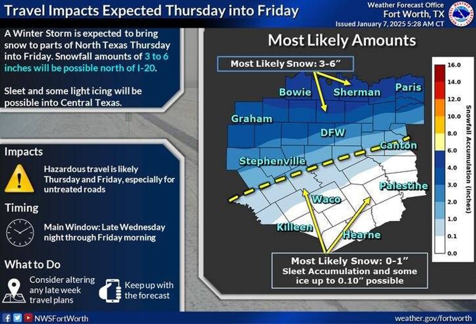
The National Weather Service has issued a Winter Storm Watch for North Texas beginning Thursday at 12 a.m. and running through 6 p.m. Friday. A strong upper-level disturbance will cruise through North Texas on Thursday into Friday morning producing measurable snow and sleet across a good chunk of the area.
Things will start to unfold quickly by daybreak Thursday, as precipitation will move across the area in waves during the day, ending from west to east by 12 p.m. Friday.
Areas north of Interstate 30 will see the highest accumulations during this event. The Dallas-Fort Worth area may see 3-5 inches of snow and sleet. Areas north of Highway 380 could see 5-8 inches of snow. Areas south of Interstate 30 may see 1-3 inches. It looks like it'll be all rain south of a Longview to Canton to Hillsboro line.
It looks like North Texas may get a warm nose of air about 5,000 feet above the surface during this event. This will allow sleet to fall during the onset of this event. The sleet will transition over to snow, especially north of Interstate 30 during the day on Thursday. Areas south of Dallas and Fort Worth will see a wintry mix.
Road conditions will deteriorate through the day Thursday into Friday morning as the wintry precipitation moves out by 12 p.m. Temperatures on Thursday will struggle to hit the freezing mark.
Even though the sun most likely won't come out on Friday, solar radiation should take care of a lot of the roadways combined with the brine solution that has been applied. Afternoon highs on Friday will reach the mid to upper 30s.
Any residual water on the roadways Friday night will refreeze into Saturday morning as we drop into the 20s. Sunny and 43 for Saturday, sunny and 46 for Sunday. That should take care of most of the snow, except on the north sides of homes and buildings.
We'll start off next week sunny and chilly with highs in the mid 40s, Lows will be in the 20s.
IMPORTANT: Please keep in mind that my forecast snow totals will be tweaked as we get closer and closer to the onset of precipitation on Thursday morning. Also, please keep in mind there'll be a sharp line between higher accumulating snow and virtually no snow at all.
 North Texas travel impacts on Thursday and Friday.National Weather Service
7-Day Headlines
DFW reached 40 degrees on Monday.
Back in the 20s Tuesday morning.
Winter Storm Watch: Thursday 12 a.m. – Friday 6 p.m.
Sleet/snow for much of North Texas.
Precipitation begins Thursday morning and ends by noon Friday.
3-5 inches likely north of Interstate 30, higher totals north and northeast.
Temperatures will hover near freezing on Thursday.
Clearing, highs in the 40s this weekend. Melting occurs.
*Monday Rain: 0.00"; Monday High: 40 Low: 21
*Tuesday's Averages: High: 56; Low: 36
*Record high: 83 (2006): Record low: 6 (1912)
________________________________________________________
*January rain: Trace; Deficit: ."
*2025 Rain: Trace; Deficit:
*Sunrise: 7:32am; Sunset: 5:29pm
Tuesday: Partly to mostly cloudy and cold. High: Mid to upper 30s. Wind: North 10 mph.
Tuesday night: Partly cloudy and cold. Low: Mid to upper 20s. Wind: North 10 mph.
Wednesday: Mostly to partly cloudy and cold. High: Upper 30s. Wind: North 10mph.
Thursday: **Winter Storm Watch** Cloudy and cold. Waves of sleet and snow, (3"-5") north of I-30; higher totals north and NE. Wintry mix south of I-30. Lighter accumulations (<3.00"), mainly south of I-30. High: 29-32.
Friday. **Winter Storm Watch until 6pm** Morning snow, ending by noon, then mostly cloudy and cold. High: Mid 30s.
Saturday: Sunny and cool. Melting snow. High: Low 40s.
Sunday and Monday: Mostly sunny, continued cold. High: Mid-40s.
LISTEN on the Audacy App
Tell your Smart Speaker to "PLAY 1080 KRLD"
Sign Up to receive our KRLD Insider Newsletter for more news
Follow us on Facebook | Twitter | Instagram | YouTube


