A Winter Weather Advisory will be in place from noon Tuesday until midnight. An Extreme Cold Warning for dangerous wind chills is in effect Tuesday night through Thursday.
The Arctic front will arrive earlier than expected, prompting winter weather advisories for North Texas. Light rain and drizzle will transition to light freezing rain and freezing drizzle from northwest to southeast throughout the day and into early Wednesday. Pipe-bursting cold with sub-freezing temperatures will start late Tuesday morning through the afternoon, staying below freezing until at least noon Friday.
Tuesday began with low cloud ceilings, areas of drizzle, and temperatures in the mid-40s to low 50s. The cold front moved through southern Oklahoma and the Wichita Falls area early Tuesday, sagging south through the morning. It should reach Waco by the afternoon, arriving earlier than expected. The freeze line will be south of DFW well before dinner time.
That's why winter weather advisories are in effect from noon until midnight from northwest to southeast across North Texas. Light freezing rain and/or light freezing drizzle will start around noon northwest of DFW, mid-afternoon in DFW, and southeastern counties by this evening at the latest.
ERCOT has issued a "Weather Watch" for Wednesday to Friday, which means there's the potential for lower reserves because the crazy cold temperatures will mean higher electricity demand. Despite that, ERCOT says the grid is expected to keep up with the demand.
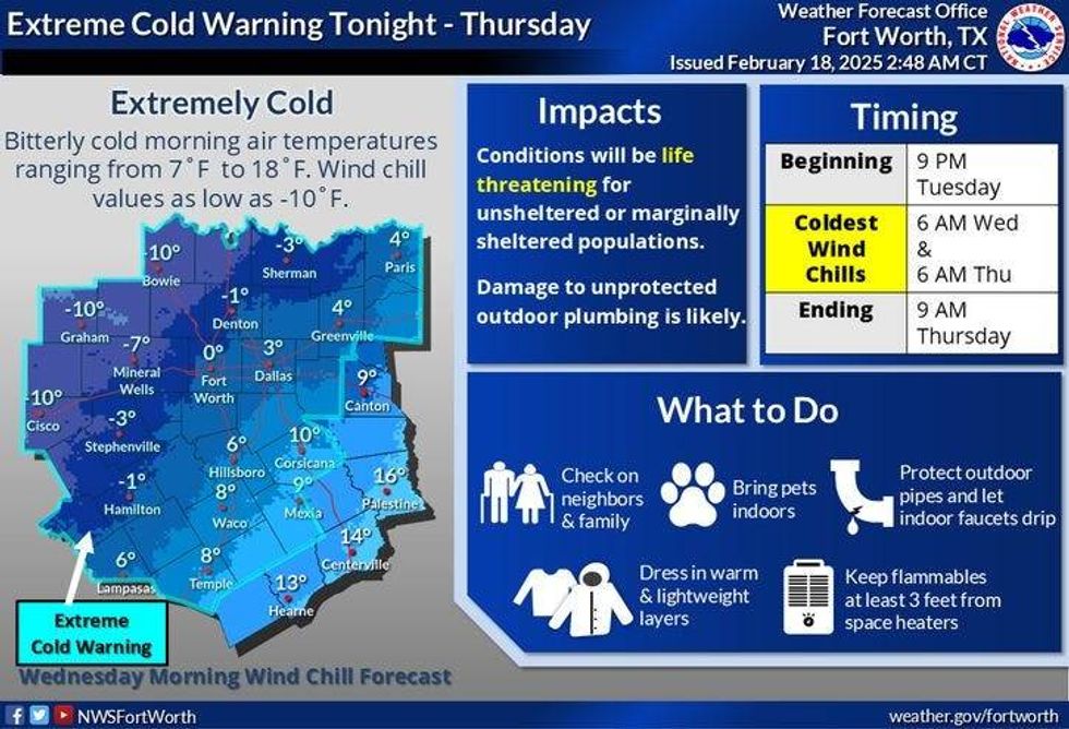 Extreme Cold Warning in effect through ThursdayNational Weather Service
Light drizzle increasing to light rain will be the weather story through the morning hours. Temperatures from northwest to southeast and radar trends will be monitored throughout the day to keep you informed on the icing and its movement. Please note this won't be a major ice storm, but even a light coating of ice can wreak havoc on roadways, especially bridges and overpasses.
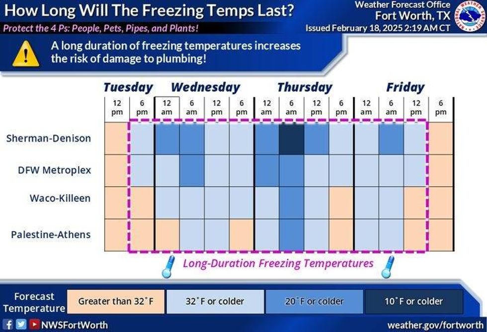
Freezing temperatures and dangerous wind chills will continue through Thursday. Morning lows on Tuesday will dip into the low to mid-teens. Afternoon highs Wednesday will struggle to get out of the low 20s, with snow flurries possible. There's a chance for lake-effect snow across area lakes on Wednesday, with water temperatures in the mid to upper 40s. Surface temperatures with wind traveling over the warm water will be in the low 20s, potentially producing an inch of snow in areas along the south shores of area lakes. Please note these bands will extend four to five miles away from the lake, making this event very localized.
Temperatures will fall into the single digits to low teens on Thursday morning under a clear sky, with wind chills below zero. Sunny skies will return, with temperatures reaching the mid to upper 20s for Thursday and mid to upper 30s for Friday, finally above freezing.
Another system will swing through the area Friday night into the first half of Saturday. We need to watch temperatures Friday night into Saturday morning due to precipitation falling.
The rain will move out the second half of Saturday, with high temperatures getting up into the 40s, 50s for Sunday, 60s for Monday, and mid to upper 70s on Tuesday. Welcome to North Texas in February.
 North Texas temperatures Tuesday-Friday, Feb. 18-22, 2025.National Weather Service
7-Day Headlines
DFW reached 56 degrees on Monday.
Winter Weather Advisory from noon until midnight.
Extreme Cold Warning through 9 a.m. Thursday morning.
Arctic blast arrives late morning through afternoon.
Drizzle & light rain early, light freezing rain & drizzle from NW to SE.
Snow flurries Wednesday. Dangerous COLD! Dangerous wind chills.
Temps below freezing until noonish Friday.
Watching Friday night for a light wintry mix.
70s by Monday!!
*Monday Rain: 0.00"; Monday High: 56 Low: 29
*Tuesday's Averages: High: 62; Low: 41
*Record high: 85 (1986): Record low: 10 (1936)
_________________________________________________________
*February Rain: 1.26"; Deficit:
*2025 Rain: 6.95"; Surplus: 2.97"
*Sunrise: 7:08am; Sunset: 6:16pm
_________________________________________________________
Tuesday: *Winter Weather Advisory starts at noon* Cloudy, turning windy and sharply colder. Areas of light rain and drizzle early. Areas of FREEZING drizzle and light FREEZING rain by afternoon into the evening. High: 50s early, 20s by this evening. Wind: North 15-25, G35 mph.
Tuesday night: *Extreme Cold Warning starts at 9 pm*, **Winter Weather Advisory ends at midnight*, but it may be extended. Cloudy, with light FREEZING drizzle and snow flurries. Low: 10-15, wind chills minus 10 to 0. Wind: North 20-30, G35 mph.
Wednesday: *Extreme Cold Warning* Cloudy, windy, and COLD with snow flurries and isolated lake-effect snow. Isolated/minor accumulations. High: Low 20s. Wind: North 15-25, G30 mph.
Thursday: Record morning lows. Sunny and cold. Low: 8-12 (record 19); High: Mid to upper 20s.
Friday: Increasing clouds and cold. Precipitation is possible late. High: Mid to upper 30s.
Saturday: Morning precipitation possible. Mostly cloudy and chilly. High: Mid to upper 30s.
Sunday: Mostly sunny and MUCH warmer. High: Mid-50s.
Monday: Mostly sunny and AWESOME! High: Low 70s.
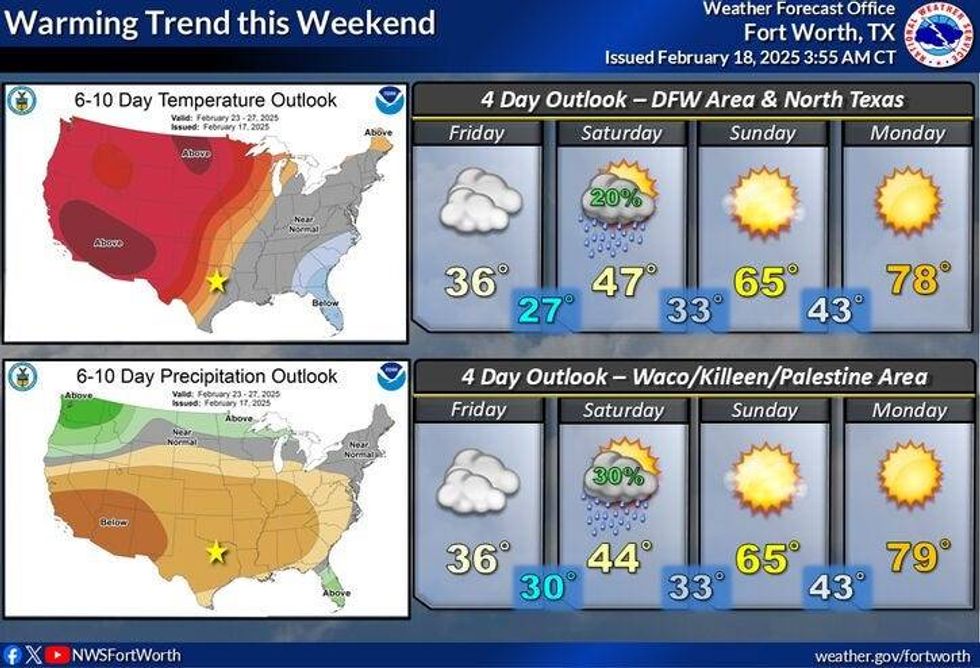 North Texas weekend forecast.National Weather Service
LISTEN on the Audacy App
Tell your Smart Speaker to "PLAY 1080 KRLD"
Sign Up to receive our KRLD Insider Newsletter for more news
Follow us on Facebook | Twitter | Instagram | YouTube