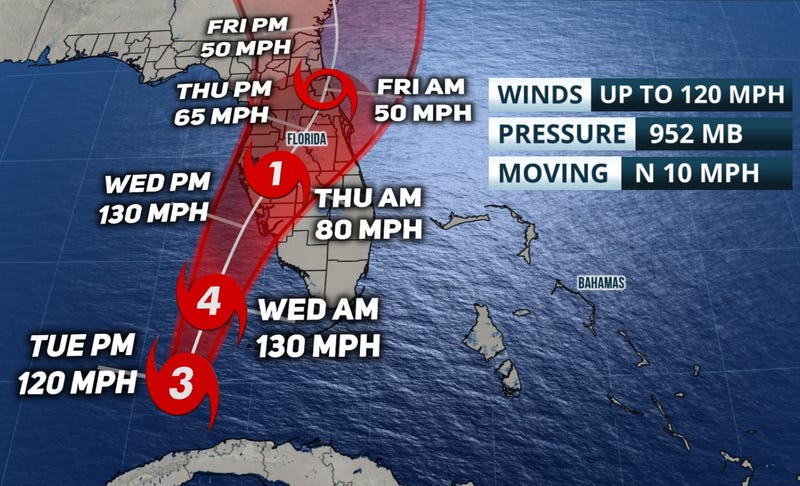
(ACCUWEATHER) Floridians rushed to evacuate on Tuesday ahead of Hurricane Ian as the Category 3 storm, packing maximum sustained winds of 120 mph, emerged over the eastern Gulf of Mexico. Rapid intensification resumed after the storm pounded the western tip of Cuba with fierce winds and life-threatening storm surge, becoming the strongest storm to make landfall there since Category 5 Hurricane Irma in 2017.
The major hurricane, which is set to strengthen further and reach Category 4 force later Tuesday or early Wednesday over the bath-warm waters of the eastern Gulf of Mexico, will make landfall along the west coast of Florida Wednesday evening, putting places from Tampa to Fort Myers at risk for extremely dangerous storm surge among other hazards.
Ian was swirling 200 miles south of Sarasota, Florida, as of Tuesday afternoon and was moving northward at 10 mph.
A Hurricane Warning has been extended southward on the west coast of Florida, from Chokoloskee to Anclote River, including Tampa Bay as well as the Dry Tortugas.
After exploding into a Category 4 storm, Ian will lose some wind intensity due to disruptive wind shear before it turns to the northeast and makes landfall along the west-central coast of Florida late Wednesday to Wednesday night. The full force of a major hurricane should be expected as Ian slams into central Florida.
As steering breezes ease at midweek, there is the potential for the storm to slow down as it nears the Florida coast and drifts inland, which can exacerbate dangers by increasing the duration of flooding rain, high winds and coastal inundation.
The effects of the large hurricane will be far-reaching across the Florida Peninsula with damaging wind gusts and power outages possible throughout. The greatest risk to lives and property will be due to storm surge and coastal inundation.
