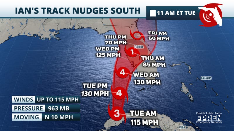

(ACCUWEATHER) Floridians rushed to evacuate Tuesday ahead of Hurricane Ian as the Category 3 storm, packing maximum sustained winds of 115 mph down from 125 mph earlier in the morning, pounded the western tip of Cuba with fierce winds and life-threatening storm surge. Ian became the strongest storm to make landfall in Cuba since Category 5 Hurricane Irma in 2017.
The major hurricane, which is set to strengthen further and reach Category 4 force later Tuesday or Wednesday over the bath-warm waters of the eastern Gulf of Mexico, will make landfall along the west coast of Florida Wednesday night, putting places like Tampa and points farther south at risk for extremely dangerous storm surge among other hazards.
Ian was swirling 305 miles southwest of Sarasota as of Tuesday morning and was moving northward at 12 mph. Hurricane-force winds extended outward 35 miles and winds of tropical storm force reached 115 miles from the center, according to the National Hurricane Center (NHC).
Hurricane warnings were in effect along the Florida west coast from Bonita Beach to Anclote River, including Tampa Bay, as well as the Dry Tortugas. A tropical storm warning was in effect from north of Anclote River to the Suwannee River.
As an additional factor, Ian is likely to slow down on approach to land, increasing the amount of time that heavy rain and a major storm surge will batter the coast. While Ian could lose a bit of wind intensity as it moves at such a slow pace, damage and impacts along the coast could be substantially worse. As such, it is important to not just focus on Ian's category on the Saffir-Simpson Hurricane Wind Scale, but also the rain and surge impacts.
Regardless of Ian's wind speed and category at landfall, extreme impacts are likely to come in the form of extremely heavy rain. As is often the case with hurricanes, Ian's heaviest rainfall is expected to fall east of the storm's center. Because of this, cities such as Orlando and Jacksonville could all have a general 4-8 inches of rainfall, with locally higher amounts. Meanwhile, locations near Tampa could see even higher totals surpassing a foot in spots. Depending on where the heaviest rain falls, a localized spot or two could see rainfall totals approach 20-30 inches, which would cause extensive flooding given the slow-moving nature of the storm.
Along with the likelihood of flooding and high winds directly from Ian will be the potential for severe thunderstorms and tornadoes over the Peninsula, especially were pockets of dry air allow the sun to emerge for a time.
With mandatory evacuation orders underway for some counties in the Tampa area due to Hurricane Ian, including Hillsborough County, evacuation shelters have been set up for those in need. Hillsborough County officials have advised those in the area that shelters are opened on an “as-needed” basis, and that shelter openings may vary with each emergency.
Florida's largest utility company, Florida Power and Light, has released a statement saying they are preparing for the impacts caused by Hurricane Ian in the coming days. The company said they are preparing for widespread outages that could last multiple days as a result of the storm and urges customers to take precautions. FPL is mobilizing and pre-positioning its restoration workforce, which consists of over 13,000 personnel. The company also said they are finalizing logistics for staging sites in the areas that will likely be most affected and coordinating with county and state emergency operation centers about response. "Immediately following the hurricane, once winds drop below 35 miles per hour, FPL will continue restoration and conduct damage assessments with field crews," the company said in an online statement.
With Hurricane Ian continuing to strengthen and now on Florida's doorstep, many localities have made the decision to close schools, often for the remainder of the week.
According to Florida Gov. Ron DeSantis on Monday evening, school districts within 24 counties have already decided to close, with more likely to follow suit. That number had grown to nearly 30 later at night, according to a list provided by the Florida Department of Education.
University of Florida has cancelled classes Wednesday through Friday, including in-person and all on-line classes.
In some areas of the state, local school buildings will be designated as storm shelters for those in need of a place to ride out the storm. The Florida Division of Emergency Management is maintaining a list of shelters available in each county.