Buffalo, N.Y. (WBEN) - Snow, snow and more snow! A wintry holiday week is unfolding across the Buffalo-Niagara and Western New York region.
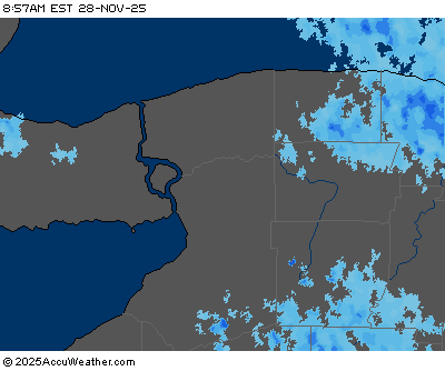
A weather system will push through the region early Tuesday while producing a general one to three inch snowfall, with some localized higher amounts east of Lake Erie.
CHECK: WBEN Closings!
Then? We welcome back lake effect, which will begin to ramp up and again impact the metro Buffalo area Tuesday afternoon. "As we go into this afternoon, we'll start to see the lake effect ramp up again off the east end of Lake Erie," National Weather Service meteorologist Jim Mitchell tells WBEN. "That will be mainly across the southern tier and southern Erie County through late tonight." The southern portion of the region can expect 6 to 12 inches from the first wave of lake effect.
The lake effect snow band will then begin to shift north late Tuesday and into Wednesday, shifting into the Buffalo metro area, impacting both the Wednesday morning and afternoon commutes. "That's when we'll see the heaviest snow here, will be Wednesday and Wednesday evening. Total snow accumulation for the central Erie County area could be in excess of a foot of snow and up to 2 feet in spots, says Mitchell. "Most of that is going to fall from very late tonight and through the first half of Wednesday night."
With snow rates of up to 2 inches per hour in spots and gusty winds, poor visibility will be an issue within the lake snow band. "The difference with this one is the winds aren't going to be as strong," Mitchell says. The highest winds will be Wednesday afternoon and evening with gusts to 40 mph. "The winds don't look to be as much of a factor nearly as they were over this past weekend."
Mitchell says the band will again shift to the south late Wednesday and into Thursday morning. "As it wakens it will shift back north Thursday afternoon and we may get several inches from that," he adds, before it will completely fall apart.
A Lake Effect Snow Warning is posted for Erie, Genesee and Wyoming counties Tuesday afternoon through Thursday with Accumulations in excess of foot possible across the entire time period.
A Winter Weather Advisory is posted for Chautauqua and Cattaraugus counties Tuesday with lesser accumulations forecast.
LAKE EFFECT SNOW WARNING IN EFFECT FROM 1 PM THIS AFTERNOON TO 7 PM EST THURSDAY
* WHAT...Heavy lake effect snow expected. Total snow accumulations of 1 to 3 feet in the most persistent lake snows, with the greatest amounts expected across central and northern Erie County. Lake band centered on Ski Country Tuesday afternoon, will slowly shift north through southern Erie and Wyoming counties Tuesday night reaching the Buffalo Metro area by early Wednesday morning, where it will remain through the first half of Wednesday night. Lake band will then shift back south of Buffalo later Wednesday night into Thursday morning, before shifting back north across the Buffalo Metro area Thursday afternoon and weakening. Winds gusting as high as 40 mph, mainly Wednesday afternoon and evening.
* WHERE...Erie, Genesee, and Wyoming counties.
* WHEN...From 1 PM this afternoon to 7 PM EST Thursday.
* IMPACTS...Travel could be very difficult to impossible. The hazardous conditions could impact the morning or evening commute. The cold wind chills as low as 20 below zero Wednesday night could result in hypothermia if precautions are not taken.
PRECAUTIONARY/PREPAREDNESS ACTIONS...
Heavy snow will fall in relatively narrow bands. If traveling, be prepared for rapidly changing road conditions and visibilities.
WINTER WEATHER ADVISORY REMAINS IN EFFECT FROM 6 AM TO 6 PM EST TUESDAY
* WHAT...Snow expected. Total snow accumulations of 4 to 7 inches.
* WHERE...Chautauqua and Cattaraugus counties.
* WHEN...From 6 AM to 6 PM EST Tuesday.
* IMPACTS...Plan on snow covered and slippery road conditions. The hazardous conditions will impact the Tuesday morning and evening commutes.
PRECAUTIONARY/PREPAREDNESS ACTIONS...
Periods of snow will result in snow covered roads and limited visibilities. Slow down and use caution while driving.