


Buffalo, N.Y. (WBEN) - It was an alarming situation late Thursday as some residents in the Lexington Green neighborhood in West Seneca were forced to leave their homes as flood waters rose from the Buffalo Creek.
CHECK: WBEN Closings
The East Seneca Fire Company was out in the neighborhood using a rescue boat to assist some residents in leaving their homes.
Flooded out intersections in portions of the metro Buffalo area were not uncommon as waters from flood-prone waterway spilled over their banks. Mineral Springs and South Odgen was flooded out and was photographed by FBNY with a lone abandoned vehicle in the intersection.
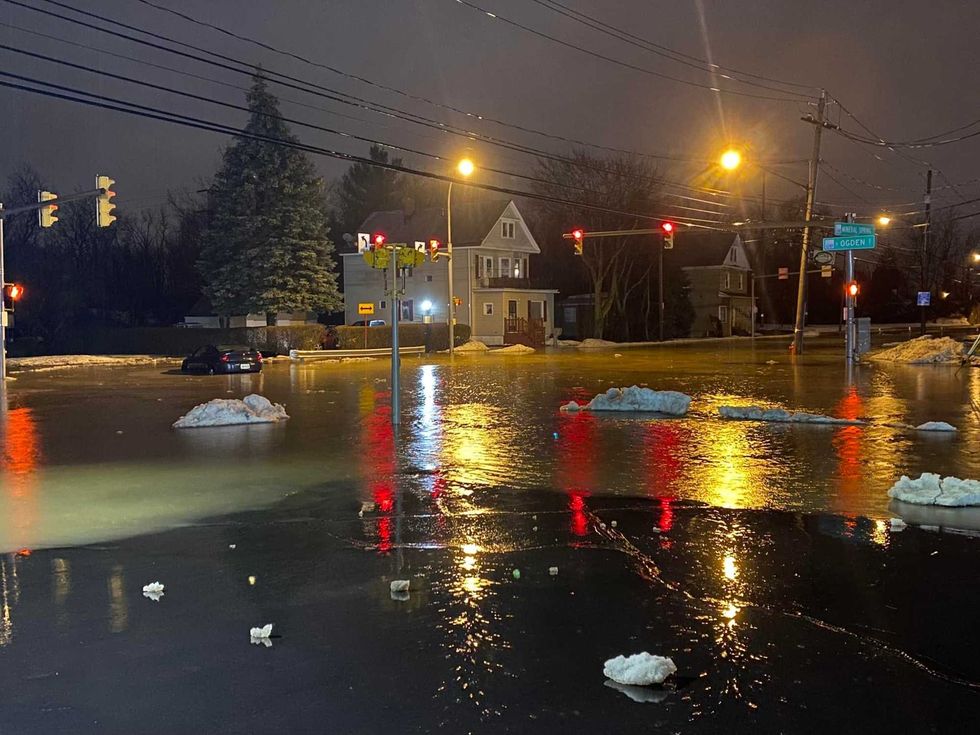 2/17/22-The intersection of Mineral Springs & South Ogden Streets was completely flooded and a lone car sits abandoned in the intersection around 9:40 pm this evening. Large parts of South Buffalo and West Seneca remain flooded/FBNY
The temperatures have fallen below freezing and standing water has turned to ice and the rain has been replaced with snow, making many area roadways slippery and difficult to travel. The widespread snow will end by mid-morning Friday.
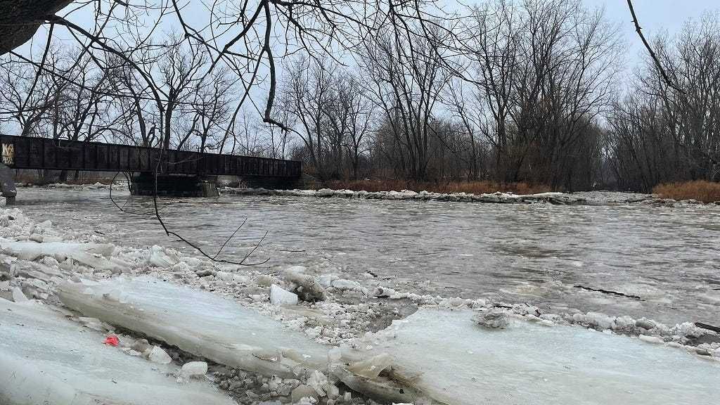
Flooding remains an active concern Friday and into the weekend as waters are cresting, and in some cases, still rising on area creeks, rivers and streams.
"Even though temperatures are below freezing now, all that water that entered the small streams and creeks still has to continue downstream, so flooding will continue, National Weather Service meteorologist John Hitchcok told WBEN in a LiveLine interview early Friday.
Hitchcock says the situation with flooding will improve for much of the region through the day Friday. "The faster responding creeks....Cazenovia, Buffalo Creek, they will peak this morning and start to recede this afternoon." There are, however, some slower responding waterways that will remain problematic into the weekend. "The slowest river of all is Tonawanda Creek, and that will continue to rise even through the weekend. It actually won't reach its peak stage until over the weekend." Flooding may worsen along Tonawanda Creek through the weekend, says Hitchcock.
Lakeshore Flood Watch
Lakeshore Hazard Message National Weather Service Buffalo NY 230 PM EST Fri Feb 18 2022 NYZ010-019-085-190330- /O.NEW.KBUF.LS.A.0001.220219T0600Z-220219T1500Z/ Northern Erie-Chautauqua-Southern Erie- 230 PM EST Fri Feb 18 2022 ...LAKESHORE FLOOD WATCH IN EFFECT FROM 1 AM EST SATURDAY THROUGH SATURDAY MORNING...
* WHAT...Significant lakeshore flooding possible along with the potential for ice shoves.
* WHERE...Erie and Chautauqua counties.
* WHEN...From 1 AM EST Saturday through Saturday morning.
* IMPACTS...Despite the presence of ice floes on eastern Lake Erie, strong southwest winds are expected to shift ice around which could lead to erratic water level rises at the eastern end of Lake Erie. There is a potential of localized ice shoves as well. In addition, shoreline areas free of ice could experience lakeshore flooding. This includes along Route 5 in Hamburg, Buffalo Harbor and Canalside, Dunkirk Harbor, and other flood prone locations. Very high wave action where little shoreline ice is present may also result in significant shoreline erosion.
PRECAUTIONARY/PREPAREDNESS ACTIONS...
A Lakeshore Flood Watch means that conditions favorable for lakeshore flooding are expected to develop. Residents on or near the shore should take action to protect property, and listen to local radio, television, or NOAA Weather Radio for later statements or warnings.
&& $$ JLA
Hazardous Weather OutlookHazardous Weather Outlook National Weather Service Buffalo NY 258 PM EST Fri Feb 18 2022 NYZ010-019-085-192000- Northern Erie-Chautauqua-Southern Erie- 258 PM EST Fri Feb 18 2022 ...WIND ADVISORY IN EFFECT FROM 1 AM TO 1 PM EST SATURDAY...
...LAKESHORE FLOOD WATCH IN EFFECT FROM 1 AM EST SATURDAY THROUGH SATURDAY MORNING...
This Hazardous Weather Outlook is for portions of western New York.
.DAY ONE...This afternoon and tonight.
Please listen to NOAA Weather Radio or go to weather.gov on the Internet for more information about the following hazards.
Wind Advisory.
Lakeshore Flood Watch.
.DAYS TWO THROUGH SEVEN...Saturday through Thursday.
Please listen to NOAA Weather Radio or go to weather.gov on the Internet for more information about the following hazards.
Wind Advisory.
Lakeshore Flood Watch.
Low pressure passing just north of the region will produce strong wind gusts over 50 mph late tonight and Saturday morning. A few inches of snow is also possible, along with extensive blowing and drifting snow.
.SPOTTER INFORMATION STATEMENT...
Spotter activation is not expected at this time.
This product, along with other watches, warnings, advisories, and statements issued by the National Weather Service office in Buffalo can be found on the internet at https://www.weather.gov/buf $$
Wind AdvisoryURGENT - WEATHER MESSAGE National Weather Service Buffalo NY 159 PM EST Fri Feb 18 2022 NYZ001>003-010>012-019-085-190300- /O.NEW.KBUF.WI.Y.0002.220219T0600Z-220219T1800Z/ Niagara-Orleans-Monroe-Northern Erie-Genesee-Wyoming-Chautauqua- Southern Erie- Including the cities of Niagara Falls, Medina, Rochester, Buffalo, Batavia, Warsaw, Jamestown, Orchard Park, and Springville 159 PM EST Fri Feb 18 2022 ...WIND ADVISORY IN EFFECT FROM 1 AM TO 1 PM EST SATURDAY...
* WHAT...Southwest winds 25 to 35 mph with gusts of 50 to 55 mph expected.
* WHERE...Niagara, Orleans, Monroe, Erie, Genesee, Wyoming, and Chautauqua counties.
* WHEN...From 1 AM to 1 PM EST Saturday.
* IMPACTS...Gusty winds could blow around unsecured objects. Tree limbs could be blown down and a few power outages may result.
Snow showers during the period of stronger winds may result in reduced visibilities at times late tonight through daybreak on Saturday.
PRECAUTIONARY/PREPAREDNESS ACTIONS...
Use extra caution when driving, especially if operating a high profile vehicle. Secure outdoor objects.
&& $$
Flood WarningFlood Warning National Weather Service Buffalo NY 809 AM EST Fri Feb 18 2022 NYC003-009-029-037-051-069-121-190045- /O.EXT.KBUF.FA.W.0004.000000T0000Z-220219T0045Z/ /00000.0.RS.000000T0000Z.000000T0000Z.000000T0000Z.OO/ Allegany NY-Cattaraugus NY-Erie NY-Genesee NY-Livingston NY-Ontario NY-Wyoming NY- 809 AM EST Fri Feb 18 2022 ...FLOOD WARNING NOW IN EFFECT UNTIL 745 PM EST THIS EVENING...
* WHAT...Flooding caused by rain and snowmelt continues.
* WHERE...A portion of western New York, including the following counties, Allegany, Cattaraugus, Erie, Genesee, Livingston, Ontario and Wyoming.
* WHEN...Until 745 PM EST Friday.
* IMPACTS...Numerous roads remain closed due to flooding. Streams continue to rise due to excess runoff from earlier rainfall.
* ADDITIONAL DETAILS...
- At 807 AM EST, local law enforcement reported flooding in the warned area. Flooding is already occurring. Between 1 and 1.5 inches of rain have fallen.
- Some locations that will experience flooding include...
Batavia, Olean, Geneva, Canandaigua, Geneseo, Dansville, Wellsville, Letchworth State Park, Darien Lakes State Park, Newark, Le Roy, Pembroke, Alfred, Perry, Warsaw, Avon, Bennington, Mount Morris, Victor and Attica.
- https://www.weather.gov/safety/flood PRECAUTIONARY/PREPAREDNESS ACTIONS...
Turn around, don`t drown when encountering flooded roads. Most flood deaths occur in vehicles.
Be especially cautious at night when it is harder to recognize the dangers of flooding.
&& LAT...LON 4200 7849 4313 7847 4313 7791 4304 7795 4304 7790 4299 7791 4297 7772 4294 7776 4294 7748 4303 7748 4304 7713 4301 7696 4276 7697 4276 7731 4267 7737 4258 7737 4258 7766 4254 7766 4254 7772 4200 7775 $$ AR
Flood WarningFlood Statement National Weather Service Buffalo NY 622 AM EST Fri Feb 18 2022 ...The Flood Warning is extended for the following rivers in New York...
Tonawanda Creek At Batavia affecting Wyoming, Erie, Niagara and Genesee Counties.
.Heavy rain and snowmelt yesterday will continue to produce flooding today.
For the Tonawanda Creek...including Batavia...Minor flooding is forecast.
PRECAUTIONARY/PREPAREDNESS ACTIONS...
Caution is urged when walking near riverbanks.
Turn around, don`t drown when encountering flooded roads. Most flood deaths occur in vehicles.
Please report observed flooding to local emergency services or law enforcement and request they pass this information to the National Weather Service when you can do so safely.
Additional information is available at www.weather.gov.
The next statement will be issued this evening at 630 PM EST.
&& NYC029-037-063-121-182330- /O.EXT.KBUF.FL.W.0008.220218T1724Z-220219T0712Z/ /BTVN6.1.RS.220218T1724Z.220218T1800Z.220219T0112Z.UU/ 622 AM EST Fri Feb 18 2022 ...FLOOD WARNING NOW IN EFFECT FROM THIS AFTERNOON TO JUST AFTER MIDNIGHT TONIGHT...
* WHAT...Minor flooding is forecast.
* WHERE...Tonawanda Creek At Batavia.
* WHEN...From this afternoon to just after midnight tonight.
* IMPACTS...At 9.0 feet, Flood stage, some flooding in Batavia, possibly impacting Kibbe Park, Walnut Street, and Law Street.
Flooding in rural areas of Alexander and the lowlands of the Alabama Swamps with some road closures likely.
* ADDITIONAL DETAILS...
- At 6:00 AM EST Friday the stage was 4.7 feet.
- Forecast...The river is expected to rise above flood stage this afternoon to a crest of 9.2 feet this afternoon. It will then fall below flood stage this evening.
- Flood stage is 9.0 feet.
- Flood History...This crest compares to a previous crest of 9.0 feet on 11/25/2014.
- https://www.weather.gov/safety/flood && LAT...LON 4299 7831 4305 7863 4315 7864 4315 7810 4293 7817 4293 7832 $$ Hitchcock
Flood WarningFlood Warning National Weather Service Buffalo NY 550 AM EST Fri Feb 18 2022 ...The National Weather Service in Buffalo NY has issued a Flood Warning for the following rivers in New York...
Tonawanda Creek At Rapids affecting Erie and Niagara Counties.
For the Tonawanda Creek...including Rapids...Minor flooding is forecast.
PRECAUTIONARY/PREPAREDNESS ACTIONS...
Caution is urged when walking near riverbanks.
Turn around, don`t drown when encountering flooded roads. Most flood deaths occur in vehicles.
Additional information is available at www.weather.gov.
The next statement will be issued this evening at 600 PM EST.
&& NYC029-063-182300- /O.NEW.KBUF.FL.W.0013.220219T1400Z-220220T2100Z/ /RAPN6.1.ER.220219T1520Z.220220T0000Z.220220T1251Z.NO/ 550 AM EST Fri Feb 18 2022 ...FLOOD WARNING IN EFFECT FROM SATURDAY MORNING TO SUNDAY AFTERNOON...
* WHAT...Minor flooding is forecast.
* WHERE...Tonawanda Creek At Rapids.
* WHEN...From Saturday morning to Sunday afternoon.
* IMPACTS...At 12.0 feet, Flood stage, lowland flooding of farm areas along Tonawanda Creek between Rapids and the Tonawanda Indian Reservation. Flooding may impact Fletcher, Burdick, Kirby, and Tonawanda Creek Roads.
* ADDITIONAL DETAILS...
- At 5:00 AM EST Friday the stage was 9.1 feet.
- Forecast...The river is expected to rise above flood stage late Saturday morning to a crest of 12.8 feet Saturday evening. It will then fall below flood stage Sunday morning.
- Flood stage is 12.0 feet.
- Flood History...This crest compares to a previous crest of 12.9 feet on 01/08/2019.
- https://www.weather.gov/safety/flood && LAT...LON 4305 7863 4299 7889 4306 7889 4315 7863 4315 7847 4302 7846Lakeshore Flood WatchLakeshore Hazard Message National Weather Service Buffalo NY 230 PM EST Fri Feb 18 2022 NYZ010-019-085-190330- /O.NEW.KBUF.LS.A.0001.220219T0600Z-220219T1500Z/ Northern Erie-Chautauqua-Southern Erie- 230 PM EST Fri Feb 18 2022 ...LAKESHORE FLOOD WATCH IN EFFECT FROM 1 AM EST SATURDAY THROUGH SATURDAY MORNING...
* WHAT...Significant lakeshore flooding possible along with the potential for ice shoves.
* WHERE...Erie and Chautauqua counties.
* WHEN...From 1 AM EST Saturday through Saturday morning.
* IMPACTS...Despite the presence of ice floes on eastern Lake Erie, strong southwest winds are expected to shift ice around which could lead to erratic water level rises at the eastern end of Lake Erie. There is a potential of localized ice shoves as well. In addition, shoreline areas free of ice could experience lakeshore flooding. This includes along Route 5 in Hamburg, Buffalo Harbor and Canalside, Dunkirk Harbor, and other flood prone locations. Very high wave action where little shoreline ice is present may also result in significant shoreline erosion.
PRECAUTIONARY/PREPAREDNESS ACTIONS...
A Lakeshore Flood Watch means that conditions favorable for lakeshore flooding are expected to develop. Residents on or near the shore should take action to protect property, and listen to local radio, television, or NOAA Weather Radio for later statements or warnings.
&& $$ JLA
Hazardous Weather OutlookHazardous Weather Outlook National Weather Service Buffalo NY 258 PM EST Fri Feb 18 2022 NYZ010-019-085-192000- Northern Erie-Chautauqua-Southern Erie- 258 PM EST Fri Feb 18 2022 ...WIND ADVISORY IN EFFECT FROM 1 AM TO 1 PM EST SATURDAY...
...LAKESHORE FLOOD WATCH IN EFFECT FROM 1 AM EST SATURDAY THROUGH SATURDAY MORNING...
This Hazardous Weather Outlook is for portions of western New York.
.DAY ONE...This afternoon and tonight.
Please listen to NOAA Weather Radio or go to weather.gov on the Internet for more information about the following hazards.
Wind Advisory.
Lakeshore Flood Watch.
.DAYS TWO THROUGH SEVEN...Saturday through Thursday.
Please listen to NOAA Weather Radio or go to weather.gov on the Internet for more information about the following hazards.
Wind Advisory.
Lakeshore Flood Watch.
Low pressure passing just north of the region will produce strong wind gusts over 50 mph late tonight and Saturday morning. A few inches of snow is also possible, along with extensive blowing and drifting snow.
.SPOTTER INFORMATION STATEMENT...
Spotter activation is not expected at this time.
This product, along with other watches, warnings, advisories, and statements issued by the National Weather Service office in Buffalo can be found on the internet at https://www.weather.gov/buf $$
Wind AdvisoryURGENT - WEATHER MESSAGE National Weather Service Buffalo NY 159 PM EST Fri Feb 18 2022 NYZ001>003-010>012-019-085-190300- /O.NEW.KBUF.WI.Y.0002.220219T0600Z-220219T1800Z/ Niagara-Orleans-Monroe-Northern Erie-Genesee-Wyoming-Chautauqua- Southern Erie- Including the cities of Niagara Falls, Medina, Rochester, Buffalo, Batavia, Warsaw, Jamestown, Orchard Park, and Springville 159 PM EST Fri Feb 18 2022 ...WIND ADVISORY IN EFFECT FROM 1 AM TO 1 PM EST SATURDAY...
* WHAT...Southwest winds 25 to 35 mph with gusts of 50 to 55 mph expected.
* WHERE...Niagara, Orleans, Monroe, Erie, Genesee, Wyoming, and Chautauqua counties.
* WHEN...From 1 AM to 1 PM EST Saturday.
* IMPACTS...Gusty winds could blow around unsecured objects. Tree limbs could be blown down and a few power outages may result.
Snow showers during the period of stronger winds may result in reduced visibilities at times late tonight through daybreak on Saturday.
PRECAUTIONARY/PREPAREDNESS ACTIONS...
Use extra caution when driving, especially if operating a high profile vehicle. Secure outdoor objects.
&& $$
Flood WarningFlood Warning National Weather Service Buffalo NY 809 AM EST Fri Feb 18 2022 NYC003-009-029-037-051-069-121-190045- /O.EXT.KBUF.FA.W.0004.000000T0000Z-220219T0045Z/ /00000.0.RS.000000T0000Z.000000T0000Z.000000T0000Z.OO/ Allegany NY-Cattaraugus NY-Erie NY-Genesee NY-Livingston NY-Ontario NY-Wyoming NY- 809 AM EST Fri Feb 18 2022 ...FLOOD WARNING NOW IN EFFECT UNTIL 745 PM EST THIS EVENING...
* WHAT...Flooding caused by rain and snowmelt continues.
* WHERE...A portion of western New York, including the following counties, Allegany, Cattaraugus, Erie, Genesee, Livingston, Ontario and Wyoming.
* WHEN...Until 745 PM EST Friday.
* IMPACTS...Numerous roads remain closed due to flooding. Streams continue to rise due to excess runoff from earlier rainfall.
* ADDITIONAL DETAILS...
- At 807 AM EST, local law enforcement reported flooding in the warned area. Flooding is already occurring. Between 1 and 1.5 inches of rain have fallen.
- Some locations that will experience flooding include...
Batavia, Olean, Geneva, Canandaigua, Geneseo, Dansville, Wellsville, Letchworth State Park, Darien Lakes State Park, Newark, Le Roy, Pembroke, Alfred, Perry, Warsaw, Avon, Bennington, Mount Morris, Victor and Attica.
- https://www.weather.gov/safety/flood PRECAUTIONARY/PREPAREDNESS ACTIONS...
Turn around, don`t drown when encountering flooded roads. Most flood deaths occur in vehicles.
Be especially cautious at night when it is harder to recognize the dangers of flooding.
&& LAT...LON 4200 7849 4313 7847 4313 7791 4304 7795 4304 7790 4299 7791 4297 7772 4294 7776 4294 7748 4303 7748 4304 7713 4301 7696 4276 7697 4276 7731 4267 7737 4258 7737 4258 7766 4254 7766 4254 7772 4200 7775 $$ AR
Flood WarningFlood Statement National Weather Service Buffalo NY 622 AM EST Fri Feb 18 2022 ...The Flood Warning is extended for the following rivers in New York...
Tonawanda Creek At Batavia affecting Wyoming, Erie, Niagara and Genesee Counties.
.Heavy rain and snowmelt yesterday will continue to produce flooding today.
For the Tonawanda Creek...including Batavia...Minor flooding is forecast.
PRECAUTIONARY/PREPAREDNESS ACTIONS...
Caution is urged when walking near riverbanks.
Turn around, don`t drown when encountering flooded roads. Most flood deaths occur in vehicles.
Please report observed flooding to local emergency services or law enforcement and request they pass this information to the National Weather Service when you can do so safely.
Additional information is available at www.weather.gov.
The next statement will be issued this evening at 630 PM EST.
&& NYC029-037-063-121-182330- /O.EXT.KBUF.FL.W.0008.220218T1724Z-220219T0712Z/ /BTVN6.1.RS.220218T1724Z.220218T1800Z.220219T0112Z.UU/ 622 AM EST Fri Feb 18 2022 ...FLOOD WARNING NOW IN EFFECT FROM THIS AFTERNOON TO JUST AFTER MIDNIGHT TONIGHT...
* WHAT...Minor flooding is forecast.
* WHERE...Tonawanda Creek At Batavia.
* WHEN...From this afternoon to just after midnight tonight.
* IMPACTS...At 9.0 feet, Flood stage, some flooding in Batavia, possibly impacting Kibbe Park, Walnut Street, and Law Street.
Flooding in rural areas of Alexander and the lowlands of the Alabama Swamps with some road closures likely.
* ADDITIONAL DETAILS...
- At 6:00 AM EST Friday the stage was 4.7 feet.
- Forecast...The river is expected to rise above flood stage this afternoon to a crest of 9.2 feet this afternoon. It will then fall below flood stage this evening.
- Flood stage is 9.0 feet.
- Flood History...This crest compares to a previous crest of 9.0 feet on 11/25/2014.
- https://www.weather.gov/safety/flood && LAT...LON 4299 7831 4305 7863 4315 7864 4315 7810 4293 7817 4293 7832 $$ Hitchcock
Flood WarningFlood Warning National Weather Service Buffalo NY 550 AM EST Fri Feb 18 2022 ...The National Weather Service in Buffalo NY has issued a Flood Warning for the following rivers in New York...
Tonawanda Creek At Rapids affecting Erie and Niagara Counties.
For the Tonawanda Creek...including Rapids...Minor flooding is forecast.
PRECAUTIONARY/PREPAREDNESS ACTIONS...
Caution is urged when walking near riverbanks.
Turn around, don`t drown when encountering flooded roads. Most flood deaths occur in vehicles.
Additional information is available at www.weather.gov.
The next statement will be issued this evening at 600 PM EST.
&& NYC029-063-182300- /O.NEW.KBUF.FL.W.0013.220219T1400Z-220220T2100Z/ /RAPN6.1.ER.220219T1520Z.220220T0000Z.220220T1251Z.NO/ 550 AM EST Fri Feb 18 2022 ...FLOOD WARNING IN EFFECT FROM SATURDAY MORNING TO SUNDAY AFTERNOON...
* WHAT...Minor flooding is forecast.
* WHERE...Tonawanda Creek At Rapids.
* WHEN...From Saturday morning to Sunday afternoon.
* IMPACTS...At 12.0 feet, Flood stage, lowland flooding of farm areas along Tonawanda Creek between Rapids and the Tonawanda Indian Reservation. Flooding may impact Fletcher, Burdick, Kirby, and Tonawanda Creek Roads.
* ADDITIONAL DETAILS...
- At 5:00 AM EST Friday the stage was 9.1 feet.
- Forecast...The river is expected to rise above flood stage late Saturday morning to a crest of 12.8 feet Saturday evening. It will then fall below flood stage Sunday morning.
- Flood stage is 12.0 feet.
- Flood History...This crest compares to a previous crest of 12.9 feet on 01/08/2019.
- https://www.weather.gov/safety/flood && LAT...LON 4305 7863 4299 7889 4306 7889 4315 7863 4315 7847 4302 7846


