Buffalo, NY (WBEN) With several feet of snowfall possible this weekend, a longtime meteorologist says there are signals days in advance of a huge lake effect event. He says there remains one challenge: that's predicting which area gets hit hardest.
Freelance meteorologist Andy Parker says this particular storm could be forecast more easily than past storms. "You've got the warm waters of the lake, we're measuring that we're in the 50s, the air temperatures that are coming our way, are going to drop into the 20s. All you need is a 23 degree temperature difference between the lake temperature and the air temperature not above the lake, at the surface, but a mile up," explains Parker. "We are way beyond that 23 degrees, then you just need a weather system in the area to stir things up a bit and create some lift." He says the biggest thing about this one is that it's going to be here Friday, Saturday and Sunday, a three day event.
Parker says this storm is different than the October surprise storm of 2006. "That storm when it was developing was with much more marginal air temperatures, your numbers will need about 39 degrees when the snow began to fall," recalls Parker. He says it was a heavy, wet snow, but it could've gone either way, rain or snow. "It decided to go snow. And we all know what happened in October," says Parker. He says the 2014 Snowvember event was known to be a lake effect storm. "It started with the intensity that we expected. But then the intensity of that storm, the rate of snow within the band jumped to levels that were historic four and five inches an hour." says Parker. He adds the band was anticipated to wobble and spread the snow around, locked in on one spot and just "plastered Lancaster, with up to seven feet of snow."
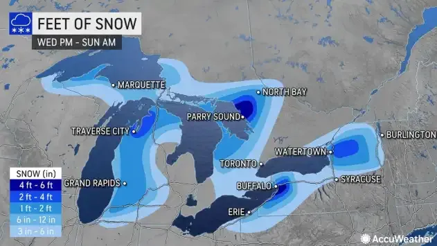
Parker says when it comes to lake effect, he says there's one variable hard to predict: the wind direction. "The wind is the thing that drives the lake effect band," explains Parker. "We can predict that a lake effect band is going to develop and then it's about where the wind is going to push it. And if the wind locks into one direction, that lake band does very little moving. If the wind begins to shift, it's that move. It's the movement of the lake band that begins to spread the snow around." He says with this particular storm, winds are unidirectional, straight out of the southwest, meaning very little variance. That means everyone will get hit.
Parker can answer your weather questions by calling 716-503-2639