

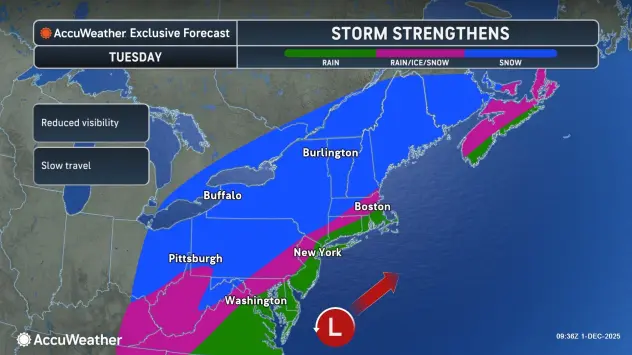
After a fairly quiet and cold Monday, another weather system will impact the Buffalo-Niagara and Western New York region Tuesday, bringing additional accumulating snow.
And, beyond that, below average temperatures and chances for daily snow will persist through the end of the week.
After diminishing lake effect snow and winds Monday, the next weather system will begin to impact the region Tuesday, National Weather Service meteorologist Liz Jurkowski tells WBEN.
"We'll see some widespread snow tonight and into Tuesday," Jurkowski says.
A Winter Weather Advisory is now posted Tuesday for ALL of Western New York.
As for accumulations from this snow system, a general 2 to 4 inches is forecast across the Niagara Frontier, with 4 to 6 inches across the the southern tier.
Colder weather will hang with us through the remainder of the week, with Thursday expected to be the coldest day, with highs peaking in the 20's.
Additional snow, possibly 1 to 3 inches, is expected from another weather system on Wednesday.
WINTER WEATHER ADVISORY IN EFFECT FROM 1 AM TO 7 PM EST TUESDAY
* WHAT...Snow expected. Total snow accumulations 2 to 4 inches. The snow will peak in intensity during the Tuesday morning commute.
* WHERE...Niagara, Orleans, Monroe, Northern Erie, and Genesee Counties.
* WHEN...From 1 AM to 7 PM EST Tuesday.
* IMPACTS...Plan on snow covered and slippery road conditions with reduced visibility. The hazardous conditions will impact the Tuesday morning commute.
PRECAUTIONARY/PREPAREDNESS ACTIONS...
Periods of snow will result in snow covered roads and limited visibilities. Slow down and use caution while driving.
WINTER WEATHER ADVISORY IN EFFECT FROM 1 AM TO 7 PM EST TUESDAY
* WHAT...Snow expected. Total snow accumulations 4 to 6 inches.
* WHERE...Wayne, Northern Cayuga, Oswego, Wyoming, Livingston, Ontario, Chautauqua, Cattaraugus, Allegany, and Southern Erie Counties.
* WHEN...From 1 AM to 7 PM EST Tuesday.
* IMPACTS...Travel will be difficult. The hazardous conditions will impact the Tuesday morning and evening commutes.
PRECAUTIONARY/PREPAREDNESS ACTIONS...
Periods of snow will result in snow covered roads and limited visibilities. Slow down and use caution while driving.