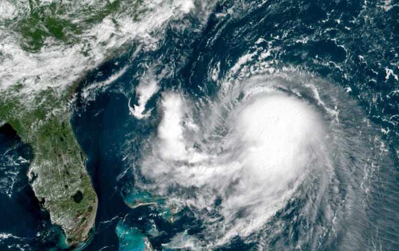

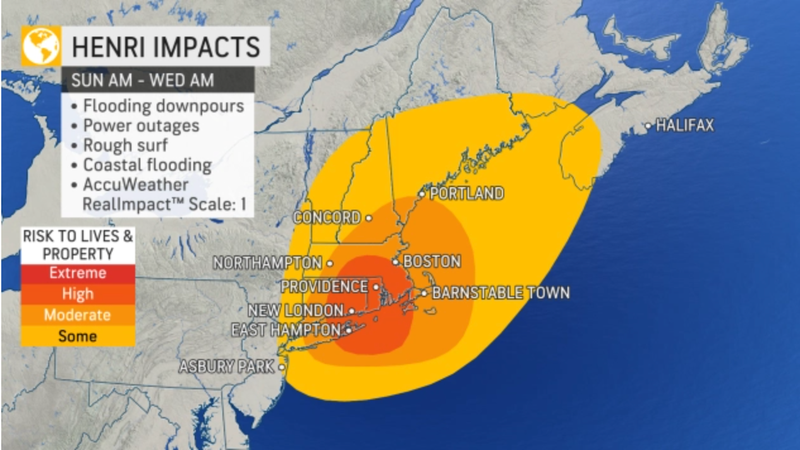
NEW YORK – Tropical Storm Henri has been upgraded to a hurricane as it approaches Long Island and New England Saturday, bringing potentially dangerous storm surges to the New York City area, the National Weather Service announced Saturday morning.
Hurricane Warnings are in effect for parts of Long Island and southern New England as Henri's winds reach a maximum speed of 75 miles per hour. The hurricane could mark the first time Long Island is directly hit by such a storm in nearly 36 years, according to AccuWeather.
"A Dangerous Storm Surge, Hurricane Conditions, and Flooding Rainfall Expected in Portions of the Northeast United States Beginning Late Tonight Or Early Sunday," the NWS. tweeted.
Suffolk County Executive Steven Bellone urged Long Islanders to take the storm seriously on Saturday.
"This storm is significant and potentially dangerous and is like to [be] really impactful in a variety of ways," he said.
Bellone announced a voluntary evacuation order for residents and vistors of Fire island on Saturday. Ferry service to and from the island has been canceled Sunday, with Bellone warning that he is not sure when boats will be able to run again.
"We are urging residents and visitors of Fire Island to leave Fire Island today for their own safety," he said.
Tropical Storm Watches are in effect for New York City and Hudson, Middlesex, Monmouth, Bergen, Essex and Union counties in New Jersey.
Hurricane Warnings are in effect for Suffolk County on Long Island, as well as southern parts of New Haven, Middlesex and New London counties in Connecticut. Tropical Storm Warnings are in effect for Nassau County, southern Fairfield County in Connecticut and southern Westchester County.
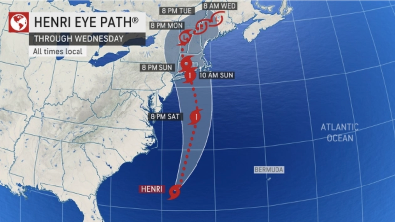
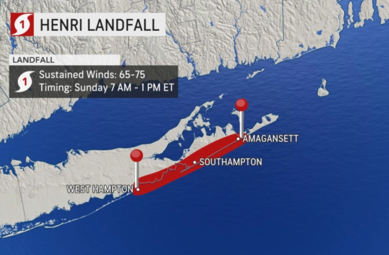
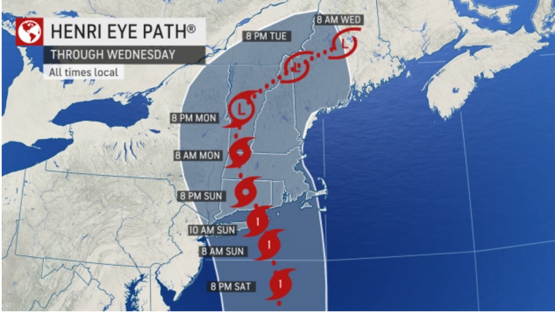
AccuWeather is currently calling for Henri to make landfall along The Hamptons on Long Island Sunday morning or early afternoon. Meteorologists warned that Henri’s projected landfall on Long Island coincides with a full moon — which could mean higher tides and more coastal flooding.
Related

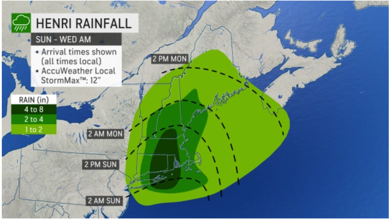
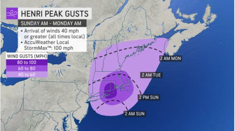
AccuWeather projects the heaviest rainfall of 4-8 inches could come for eastern Long Island, and parts of Connecticut, Rhode Island and central Massachusetts. Wind gusts of 40-60 mph are expected as far north as Maine, but Long Island, Connecticut and Rhode Island could see gusts up to 100 mph.
In Connecticut, Gov. Ned Lamont has declared a state of emergency and is warning Connecticut residents that they should prepare to "shelter in place" from Sunday afternoon through at least Monday morning.
Suffolk County Executive Steve Bellone said they are preparing for the worst case scenario.
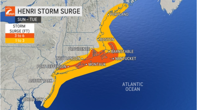
"We expect to see 8 to 12 foot waves with the potential for 12 to 16 foot waves if the storm tracks further to the west," Bellone said Friday. "Our biggest concerns, of course, are coastal flooding and as always we're preparing for what could be hurricane force winds, Category 1 sustained to 74 mile per hour winds, gusts up to 90 miles an hour."
Larger trucks to collect fallen trees and debris along with other storm equipment, including chainsaws, bucket trucks, chippers, and generators, are ready to go.
"We ask that you dial 911 only for life threatening emergencies," Bellone said. "When an event like this occurs 911 gets inundated with calls. We want to make sure that those that those lines are as clear as possible to deal with the real emergencies."
Nassau's Office of Emergency Management is also on high alert and closely monitoring Henri's track of Henri.
Related

"Our incredible workforce stands ready to address potential issues impacting the County. While we prepare our emergency vehicles and check storm drains for debris, we are asking all residents to begin securing patio furniture and other loose items in and around their homes," Nassau County Executive Laura Curran said. "At this time, we anticipate high tides, coastal flooding on both the North and South shore as well as gusty winds that may cause power outages."
Residents are being advised to have working flashlights, extra batteries, bottled water, candles and other basic essentials in case the power goes out.
As the day progresses Saturday, rough surf and rip currents develop, and the risk of coastal flooding increases, as Henri approaches.
Showers and thunderstorms will increase Saturday night before Henri passes just east of our area Sunday into Sunday night, according to current projections.
The heaviest rain and strongest winds will be felt on Long Island, which could see 2 to 4 inches of rain and gusts near hurricane force. The city and inland area could see tropical storm force gusts and up to 1 inch of rain. A change in track could impact the intensity.
Conditions should gradually improve Sunday night. Monday is cloudy with a shower in spots. The high will be 84.
Related

Related

Related
