It's not the heat, it's the humility. Or humidity, which is increasing out there, making it feel even hotter than the air temperature, which is hot enough, thank you very much. If anyone asks (doubtful) July is Minnesota's hottest month, and a typical June brings 3 days of 90-degree heat. Right. Not this year. In what may be a trend, meteorological summer (June 1 to September 1) is starting off very hot across the Upper Midwest, and I see no significant relief from the heat anytime soon. Frankly, the maps remind me a little of 1988, when we had severe heat and drought across much of the USA (and 44 days above 90F in the Twin Cities.) I'm not predicting a rerun of 1988's severe heatwave but at this point, nothing would surprise me.
 Hot Enough For 'Ya? I think I know the answer.
Welcome to the 5th day in a row of 90-degree heat. If your overheated memory needs refreshing, the mercury reached 99F on Saturday and a toasty 93F yesterday in the Twin Cities. 90s will be the norm this week, and there's a good chance we'll set record highs Wednesday and Friday of this week. On Tuesday most of Minnesota will be hotter than Texas and New Mexico, within a whisker of Arizona-levels of heat and humidity. It's a dry heat, Paul! Yeah, so is my oven, but I still don't stick my head inside.
 Consecutive Days Above 90F at MSP Data.Graphic above courtesy of the Minnesota State Climate Office
There is a very good chance every day through Friday will see daytime highs of 90F or higher in the Twin Cities. If we go through Friday that's 9 consecutive days in a row of 90+, which would tie for the 3rd longest stretch of 90s in modern-day records (since 1872). If we see 90F every day through next Monday (a distinct possibility) that would be 12 consecutive days of 90s, which would make this the second-longest streak of 90s, breaking the old record set in 1948.
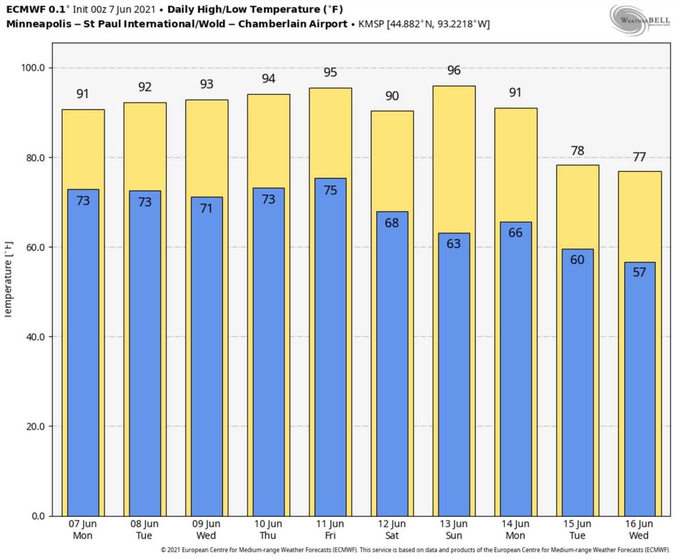
 European Model Predicted Highs for MSP.Graphic courtesy of WeatherBell
The "Euro" is predicting highs above 90F into Monday, followed by a touch of Canadian relief next week. We'll see, but I don't think this prediction is much of a stretch. We should see a slight drop in humidity Saturday and Sunday as winds blow from the northwest, but this time around there won't be much cooling until a stronger cool frontal passage roughly 1 week from now.
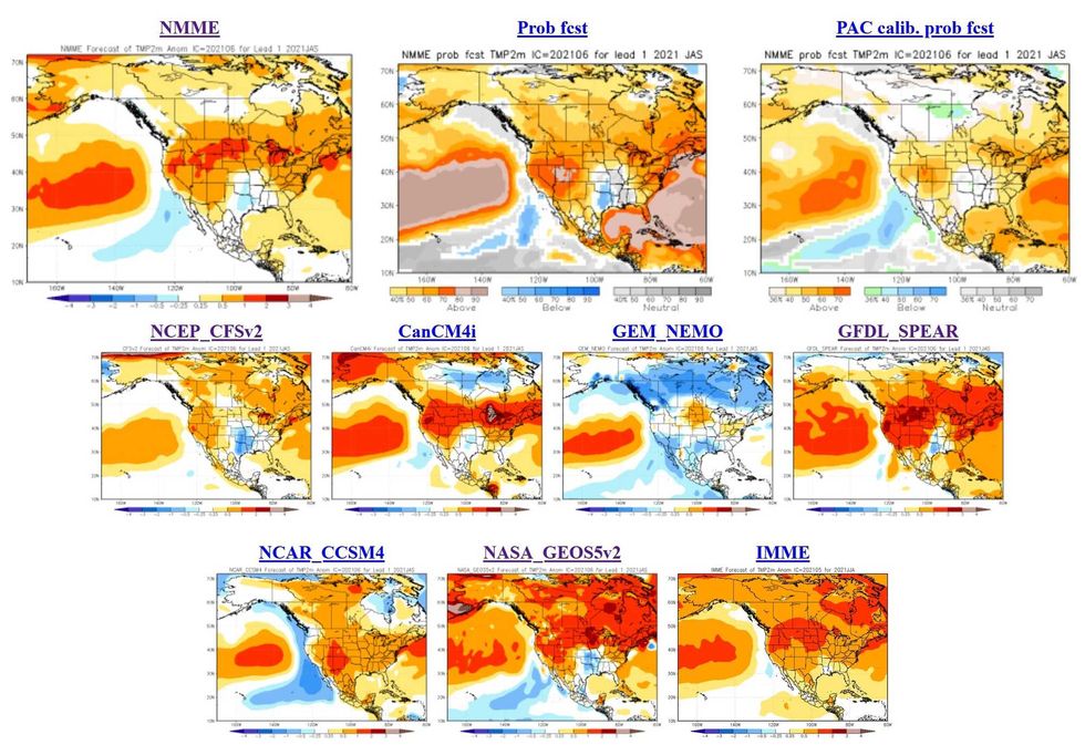
 Summer Temperatures Outlook.Courtesy of NOAA
NOAA's short-term climate models tipped meteorologists off to a hot summer a few months ago, and now pretty much every model I can find has temperature anomalies well above average into August. Is this hot stretch a fluke or a trend? Personally, I think Mother Nature is showing her hand, tapping us on the shoulder and giving fair warning of a stinking hot summer to come. I hope I'm wrong, but that's my meteorological spidey-sense.
A reminder to check in on older friends, family members and neighbors in the days to come. Daytime highs get the most media attention, but it's the cumulative effect of prolonged warmth at night that causes the most problems, especially for the elderly and people suffering from chronic ailments. After about the third or fourth night of temperatures staying above 80F - with no ability to cool off and reset your body temperatures - the suffering begins. People who don't have access to air conditioning are most at risk.
And to think, 4 months ago we were subzero, in fact for 4 days in a row back in February the mercury never rose above zero! That seems like a distant memory today, with a string of 90s yet to come. Think cool thoughts and take advantage of the constellation of cooling lakes out there - free A/C for anyone with an urge like me to go jump in a lake!