

All signs are pointing to a warmer than usual winter in Minnesota, though the experts say it's not exactly something to cheer about.
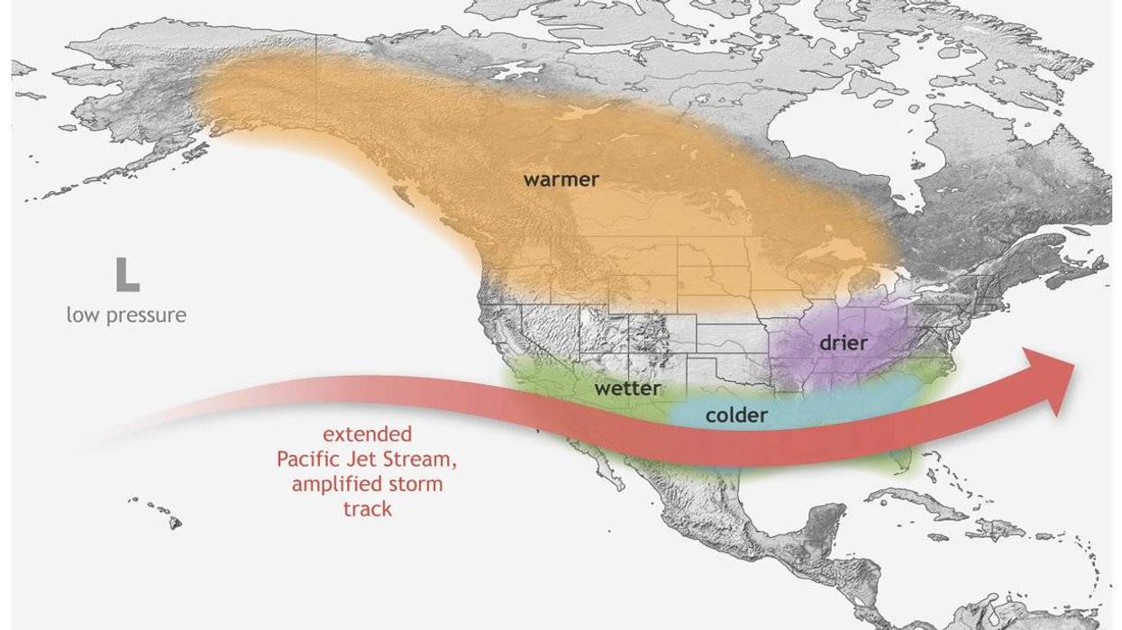
Minnesota DNR climatologist Pete Boulay says a strong El Nino pattern is expected to bring winter temperatures that are roughly 5 degrees warmer than usual. But that doesn't mean we can't get walloped by snow.
"There's certainly been snowstorms in the past with El Nino's that have hit us pretty good, and one of them is a memorable one," Boulay recalls. "The (1991) Halloween blizzard happened during an El Nino. So, just because we might have a tendency for a warm winter doesn't mean we'll escape winter."
Boulay says another El Nino winter in 2019 brought 39 inches of snow during the month of February alone.
"And that was during an El Nino winter too, so just because the tendency is for above normal temperatures and maybe less snowfall overall, it doesn't mean we're not going to have any winter at all," he adds.
There are certainly downsides to these massive El Nino winters in Minnesota, and one of the biggest casualties is our lakes, where ice formation can be spotty at best.
That has the potential to impact everything from ice fishing to snowmobiling to winter tourism in general.
During El Nino, low-level surface winds blowing from east to west across the Pacific are weakened or sometimes reversed due to higher than normal ocean temperatures. It causes a shift in the jet stream and drives record global heat, severe droughts, wildfires and shrinking water supplies.
El Nino's don’t follow a regular schedule, occurring every two to seven years on average. Some can be mild. Others can pack a punch. Almost all predictions for the current El Nino is that it will peak during the coming winter but linger well into 2027 thanks to it's strength.
The National Weather Service's climate prediction center says there is now a 75% chance that this year's El Nino could become a historic event, surpassing all recorded strengths since 1950.
"With an event of this magnitude, the chances of experiencing impacts consistent with El Niño are larger, though not guaranteed," the NWS says in it's September update. "In summary, El Niño is strengthening, with a greater than 90% chance of a very strong event during the Northern Hemisphere fall and winter 2026-27."
A lot of the early data for this El Nino shows similarities to 1997-1998 which was Minnesota's second warmest winter on record, with temps running 10 degrees above normal, a massive meteorological discrepancy where a degree or two can be a lot.
In fact, six of the seven warmest winters in Minnesota's recorded history occurred during El Nino episodes.
The Niño 1+2 region, near Peru and Ecuador, has reached a remarkable 5.36°C above average — about 0.7°C higher than the previous record from 1983. It is breaking records in both the traditional and relative sense, and is forecast to approach 6°C above average during November. https://t.co/dEk31kLiZ0
— Ben Noll (@BenNollWeather) September 30, 2026
The National Weather Service says there's a 75% chance this El Nino surpasses all previous events since 1950
The National Weather Service says there's a 75% chance this El Nino surpasses all previous events since 1950