The winds of change blowing in Minnesota today. Winter weather warnings and advisories for northwestern part of the state today and here in the metro, temperatures will fall dramatically today.
Getting Much Colder Thursday Afternoon:
WCCO Radio Chief Meteorologist Paul Douglas says those below-normal temperatures will be with us through the weekend into much of next week.
“By the drive home it’s going to be in the 30s,” Douglas says. “When you wake up in the morning it’ll be 27, 28, but the wind chill will be in the teens.”
Expect it to also be very windy Thursday afternoon as well.
Douglas adds that if you’re a fan of winter, we only delayed the inevitable.
“It’s going to stay chilly,” he says. “We delayed it, we pushed it back. For people who don’t like winter, and the snow, the ice, the wind chill, here it is. Second week of November and we’re up near 70 degrees.
We are delaying the pain. The pain is coming.”
The Dreaded “S” Word:
Douglas says looking ahead, there is the potential for snow next week with one model calling for 8 inches by Thursday.
“Look, I’m discounting it, but it’s been pretty consistent the past couple of runs,” Douglas says. “Does that mean we’re getting 8 inches of snow? No. I usually cut that in half. Even if we pick up 3 or 4 by Thursday morning that would certainly be enough to cause some issues out there.”
A clipper will come in Sunday night and Monday which Douglas says could lead to a coating of snow, but enough to cause some issues.
“Rush hour Monday morning could be an interesting, white-knuckle affair,” Douglas predicts. “Then, the more significant shot comes in Tuesday and Wednesday. Details still TBD. It’s dangerous this far out to get any level of specificity. But the models are consistently printing out plowable amounts of snow Tuesday and Wednesday.”
Expect several updates on where, when and how much snow we could get over the next few days.
Drought Relief:
The rain we saw this week helped. It’s not enough, but it helped.
“We have gotten some really significant rains,” Douglas explains. “About an inch to two inches north metro, three inches up near Hinckley just since Tuesday, Election Day. We still have drought, but this rain, this soaking, did in fact come at a really good time.”
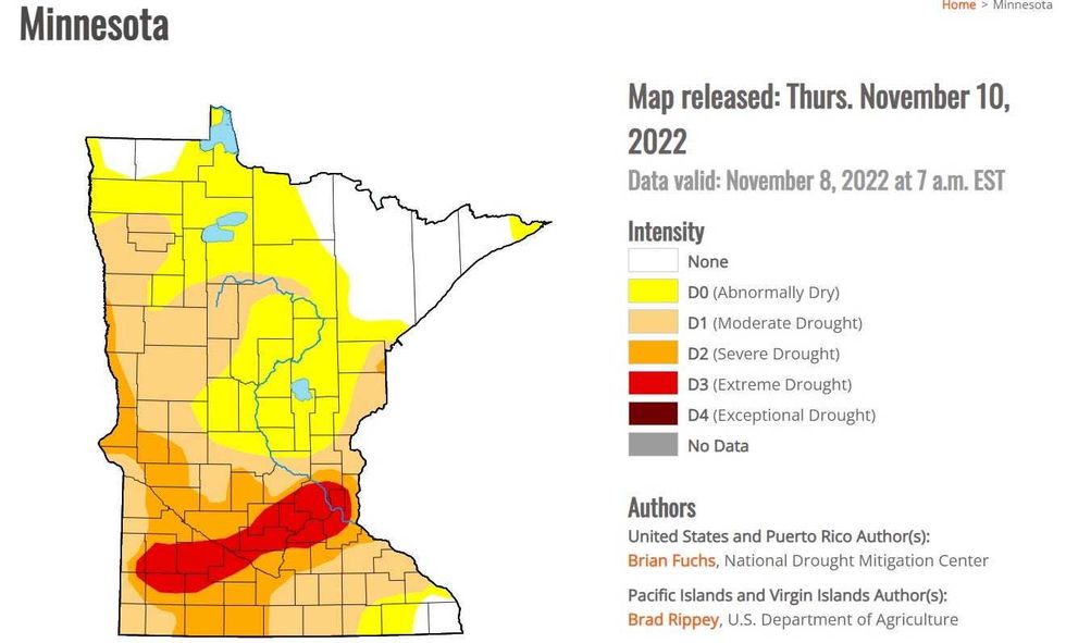 The U.S. Drought Monitor shows a large swath of Minnesota still in Extreme Drought as of Tuesday morning.(Image courtesy of the U.S. Drought Monitor / NOAA)
Look Out Northwest:
We’re on the warm side of a big storm that is dumping snow all over North Dakota and parts of Northwestern Minnesota.
“Blizzard conditions if you’re driving up 94, it’s going to be quite a drive,” Douglas told WCCO’s Vineeta Sawkar. “10 inches, maybe a foot, for far northwestern Minnesota as part of this storm.”
The National Weather Service in Grand Forks, ND says it will begin as ice on Thursday, which will lead to almost impossible travel conditions and power outages for parts of that area.
In central North Dakota, there could be spots that see upwards of 20 inches of snow. Winter has indeed arrived.