This past weekend's heavy rains have put a serious dent in our drought conditions.
According to the latest drought monitor out Thursday morning, just over 8% of Minnesota is in extreme or exceptional drought. That's down from over 28% just a week ago.
Rains totaling up to six inches in some areas fell over just a couple days, accounting for more than a month's worth of precipitation.
Those pockets of extreme drought that still exist are mainly in central and southern Minnesota.
The drought is not over, though. Moderate and severe conditions remain in much of the state, including the Twin Cities metro.
According to WCCO Chief Meteorologist Paul Douglas, parts of the state could get a little more much-needed rain Friday.
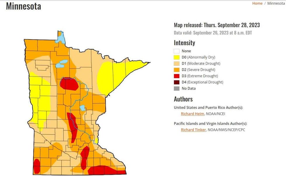 The U.S. Drought Monitor for Thursday, September 23rd still show the need for significant rain across Minnesota, but it has improved since this past weekend's deluge.(Image: U.S. Drought Monitor / NOAA)
"The storms coming in tomorrow and tomorrow night, the best chance of getting wet north and west of the Twin Cities," says Douglas. "Most of the rain north and west of St. Cloud. It could be a fairly significant amount of rain. Maybe a quarter, half an inch in some spots. Then those storms will kind of drift southward into the metro Friday night, Saturday morning. We could wake up to some booming thunder Saturday morning."
Then get ready for a return to summer with 80s and sun expected Sunday and Monday which has Medtronic Twin Cities Marathon organizers concerned about runner safety. Temperatures would be 20-plus degrees above normal for the race.
This is all before what could be a quick descent into fall. Douglas says the long-range models hint at highs in the 40s (!!!) by next weekend. Stay tuned.