In this episode of WCCO In-Depth, Mark Freie looks into the work that's underway to identify and remove what are called racial covenants from properties all across the metro and beyond.
"There's nothing ambiguous about them. They say this property may only be owned by a white person or a Caucasian person, or maybe this property cannot be owned by a Black person using some outdated language that we would now find offensive," explains Michael Corey who is the technical lead at Mapping Prejudice.
Since 2016 the Mapping Prejudice team of historians, geographers, librarians, digital humanists, and community activists has worked tirelessly to identify and map racial covenants.
Corey says racial covenants were wide-reaching when it came to who could not buy or occupy land.
"Sometimes Jewish people, often Asian people, and then some things you would see less commonly like Turkish people or things like that," Corey explains. "And so, the language is quite shocking when people see it for the first time."
In nearly a decade, Mapping Prejudice has mapped 42,000 covenant. Those covenants span over a century of history.
"Really, we think of their heyday as being between about 1910 and about the early 1950s, but we know that they go back as far as the 1890s and even some early experiments earlier in the 19th century more toward the East Coast," Corey said. "And then our latest covenant that we have in Minnesota is from 1963."
Henne Pin County Racially Restrictive Covenants by Lindsey on Scribd
While Racial covenants have been illegal since the Fair Housing Act of 1968, the racist language remains present in many housing deeds today.
Through a series of partnerships including with Just Deeds Minnesota, Mapping Prejudice works with communities to not only identify where this language still exists, but also to discharge the covenants from those deeds.
"We have 29 cities in Minnesota that are members of the Just Deeds Coalition, and each of those cities talks about this history and kind of does community engagement with their community members about this history," explained Maria Cisneros, co-founder of Just Deeds Coalition.
As for finding racial covenants, it could be a long process, but you might not have to look too far.
"What we know is that anyone who has ever looked for racial covenants has found them," Corey says. "And so I think in any metro area in the country or any small city in the country, if you go look at this historic property records, you'll find them."
That’s the story in Falcon Heights where Paula Mielke is on the city council. Mielke says there was a reckoning in 2016 following the death of Philando Castile.
"In 2016 when Philando Castile was killed here, residents started asking, just reflecting, on why that happened and just bigger issues," Mielke says. "And why is our city so white?"
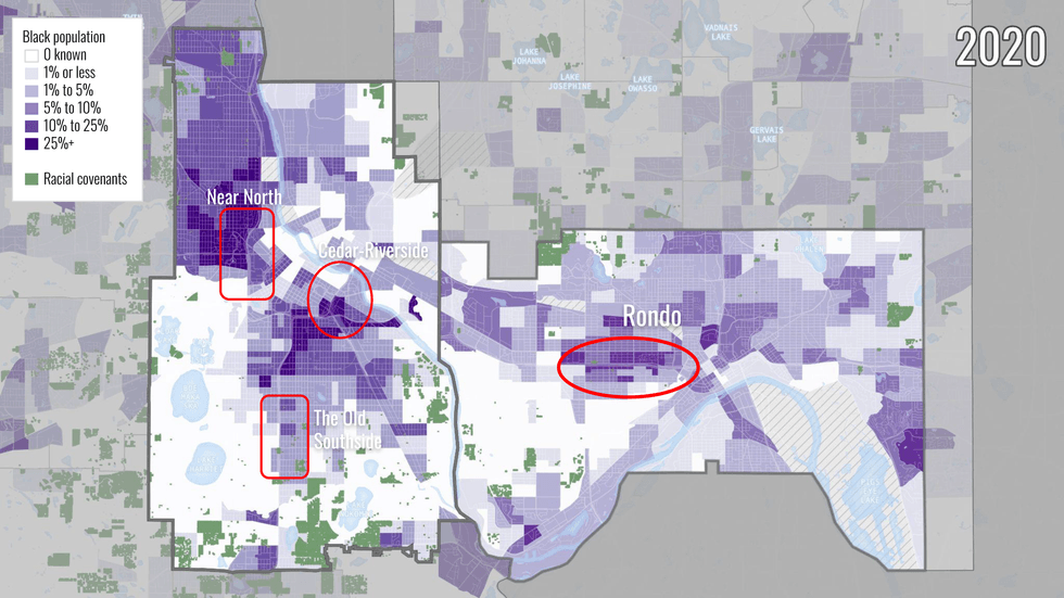 Map showing the Black population in Minneapolis and Saint Paul in 2020, with racial covenants overlaid.(Mapping Prejudice / University of Minnesota)
So began the long process of digging through Ramsey Country property records.
"At that time, Hennepin County's were all digitized, in Ramsey County they were not," Mielke explains. "So, Sharon Castle and Nancy Peterson and I spent hours in the county property records office studying microfiche and we found that there are a lot of covenants in our city."
As for that realization?
"Disturbing," Mielke calls it. "But it did explain, around that time the League of Women Voters had done a study on our city and ownership. Homeownership among Blacks in our city was 1% or even less. Initially, their study showed 0%, which we had a strong response against because we knew that we had some, sadly. Not many, but you can't just wipe them off the study and report it as 0.
For many communities and homeowners, the reality of racial covenants brings a similar reaction.
The Mapping Prejudice interactive ‘map’ of covenants adds another layer of reality to the racial disparities created through racial covenants
"And then I think once we make the map, people see these things in the neighborhood and they do, they want to do something about it," says Corey. "It's not what they want their history to be. And so I think, very understandably, people want to know, 'well, how do I how do I get this smear off of my title,' and I think that's been a very meaningful thing for a lot of people."
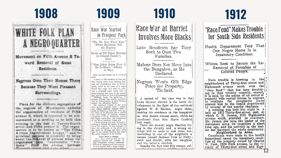 Images of archival newspaper clippings showing that during the 4 year span between 1908 and 1912, there were many instances of racist white violence over Black owned property reported in Minneapolis newspapers.(Mapping Prejudice / University of Minnesota)
Moving forward with the covenant discharge process takes time, but is doable. The first step just takes a few clicks of a computer mouse.
"And if you're in Hennepin or Ramsey Counties, you can sign up right on the website to have your covenant discharged," says Cisneros. "In both of those counties, there's probably a couple 100 people in line ahead of you, so you want to be a little bit patient."
Hennepin and Ramsey counties have waived fees for the needed discharge documents.
"We will be working with other counties to try to replicate that in other counties that mapping prejudice has mapped recently," she adds. "But if you're in Anoka or Dakota, which I think have been mapped, you're going to want to reach out directly to the county recorder's office."
Paula Mielke had the covenant and was able to go through the discharge process at her Falcon Heights home.
"It's just a long lease. I mean, there's really nothing you could do but complete the paperwork and submit it," she said.
Falcon Heights City Administrator Jack Linehan says residents are interested in the process.
Residents do seem to care," Linehan tells WCCO. "They do want to get these removed from their deeds and their, you know, their home's status."
So we did hold this event in December, that we would have attorneys available that could help start the paperwork," Mielke adds. "There were more people signed up that we could handle in a single evening, so the goal is to make that service available here at City Hall on set dates so more and more can have that and just need to keep communicating it."
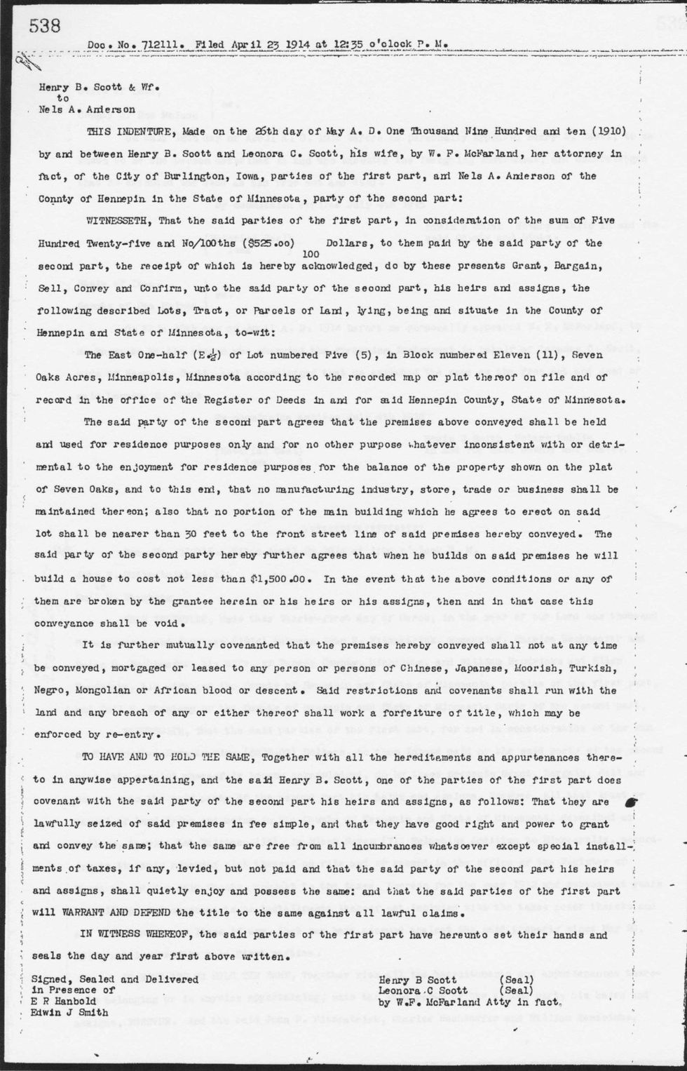 Image of the earliest racial covenant that Mapping Prejudice has found in Minnesota, which was put in place in south Minneapolis in 1910, when Henry and Leonora Scott sold a property on 35th Avenue South to Nels Anderson, a Swedish baker.(Mapping Prejudice / University of Minnesota)
So what comes after communities commit to discharging racial covenants?
"Discharging a racial covenant does not do anything about the 100 years of damage that these covenants have already done," Corey said. "And so, if this is history that you care about, and we're very glad that people do care about this history, how is that going to show up in your policy making going forward?"
Mielke says the question of what more they can do is always top of mind.
"That one is a hard one to to know, what can a city do as far as their financial help we can provide to first time buyers in our house, in our community?"
Linehan adds that one area for improvement in Falcon Heights is home ownership.
"When a home does come available, it's very hard for new home buyers to consider and to purchase and so that's something that is a challenge," Linehan explained. "And something that we, in our comprehensive plan, look to do is try to do more home affordable home ownership, so creating opportunities for people to purchase affordably homes. So that requires city involvement, other partners."
And at Just Deeds, covenants are personal
"I actually had a covenant on my house, and that's one of the reasons we started this project, is my husband and I went through this process while we were purchasing," Cisneron says. In the house, discovering that there was a covenant. We're a mixed race family and had to have this discussion about when we bought this house, would we have been welcomed in this neighborhood?"
As more people become aware, Mapping Prejudice expands.
"We're now in conversation with over 30 counties nationwide," Corey says. "We're doing work with collaborators in Milwaukee, California, North Carolina, Washington D.C., Massachusetts, and we get another email every week. And we're trying to find ways to meet that demand, to bring our technical process which is really like the most well developed in the country. But also our methodology of of having community members involved in that work and that's what we really want to scale is that experience of community members learning together about these things because I think when our volunteers are in our mapmaking sessions.
"They are for the first time seeing this really explicit language and saying, 'hey this isn't somewhere random, this is on my street, these are maybe even last names I recognize,' and having conversations with their neighbors about that," Corey continues. "That's really the power of the process and we say all the time that the process is the product. And there's 3,000 counties in the United States. There's no way in the world in which Mapping Prejudice can map anything close to the entire country. But what we're trying to do is getting the word out to people about how to replicate this process. But really, that process of learning about this history of racism together.
"Not like, Mapping Covenants is important and it's what we're doing. But it's really having community conversations, and showing people again that the world doesn't end when you talk about racism out loud, that's what we would love to see scaled up to a lot of more places."