


Winter took an extended break so far across Minnesota, but the first dose of it is about to bring it back to harsh reality.
A major storm moving through the Midwest, originally expected to miss much of the Twin Cities, has been tweaked just enough to cause some issues for southern Minnesota. It will just brush the Twin Cities and WCCO Chief Meteorologist Paul Douglas explains that Friday into Saturday is going to be a major travel headache now.
"This looks increasingly like a plowable snowstorm," says Douglas. "We're not going to get the worst of it, by far. The worst of it stays south and east of the Twin Cities, but the latest storm track a little closer to the Twin Cities."
CHANGING STORM TRACK
Douglas says the biggest change in the forecast is how slow-moving this storm has become.
"That will prolong the snow into party of Saturday," he says.
There won't be issues on Thursday. Anything you need to get done out on the roads, Douglas says that would be the day to do it.
"The snow will start up (Friday) morning, it will get heavier as the day goes on Friday," Douglas says. "Most of it coming Friday night and then gradually tapering off. I think most of the snow is done by lunch time on Saturday."
HOW MUCH SNOW?
"The latest guidance hinting at 2-5 inches," Douglas told Vineeta Sawkar on the WCCO Morning News. "We are right on the edge of the heaviest snow. Certainly plowable by midday Saturday. The further south and east you go, the better the chance of 5, even 6 inches. Towards Stillwater, Afton, Lakeville, stand a much better chance of 4, 5, 6 inches than say Anoka, or Otsego."
Probably Plowable: latest ECMWF (not infallible but wrong less often than many other wx models) hints at 2-5". Wouldn't be surprised to see 6" in a few spots by Saturday. Cold, dry, powdery snow prone to blowing and drifting. 50 mile shift in storm track makes a big difference pic.twitter.com/ywfg0qJdKF
— Paul Douglas (@pdouglasweather) January 11, 2024
That sets up a fairly large gradient across the Twin Cities so the impact of this winter storm will vary quite a bit.
The Twin Cities are now under a Winter Storm Watch issues by the National Weather Service. Just south of the metro counties there is a Winter Storm Warning where steady snow will begin Thursday night. That continues through Friday night with total snow accumulations of 5 to 8 inches in areas including Mankato, Faribault, Owatonna, Red Wing and Rochester. That, along with blowing snow and cold temps, will make for hazardous travel conditions, especially along the I-90 corridor.
COLD SNOW MEANS TROUBLE ON THE ROADS
Speaking of cold, Douglas says this is going to be quite chilly for a snow storm and that's going to cause problems on the roads, saying he gets more nervous about storms this cold.
"That means dry, fluffy, powdery, prone to blowing and drifting," says Douglas. "I think travel, really it's going to be tough. Friday evening, I think the drive is going to be a white-knuckle drive. We've seen more snow, but when it gets this cold, single-digits and teens, the de-icing equipment MnDOT uses isn't as effective. It's going to be blowing around on the highways so it may be hard keeping the freeways open."
Some real-deal cold is on the backend of this storm according to Douglas.
"The leading edge of Arctic air next week, three, four days in single digits, three, four nights below zero, not record-setting but I think next week will be one of the two or three coldest weeks of the winter," Douglas says.
The National Weather Service says there is high confidence in wind chills reaching 20 to 30 degrees below zero by Saturday morning, and 30 to 40 degrees below zero by Sunday morning.
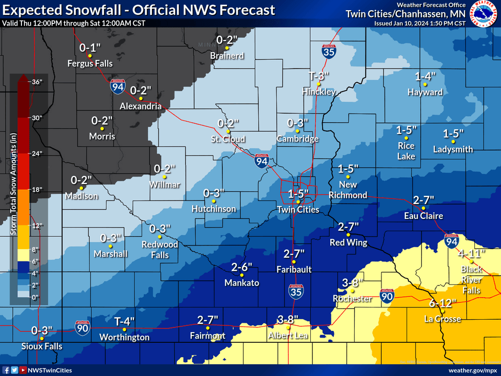 The National Weather Service Twin Cities map of potential snowfall shared Thursday morning shows a very tight gradient between a dusting of snow in St. Cloud, and up to 8 inches by Rochester.(Image courtesy of the National Weather Service Twin Cities)
MINNESOTA MISSES THE HEAVIEST SNOW
The real fireworks with this Midwestern storm will camp out over Iowa, southern Wisconsin and northern Illinois. Much of Iowa is expected to get 6-10 inches.
"Madison could get 10 or 12, and I think a foot for Chicago, maybe over a foot for Milwaukee," Douglas predicts. "It's going to be crazy out there with blizzard conditions likely by Friday night into Saturday morning. I think stuff is going to shutdown around the Great Lakes for a day or two."
The National Weather Service has issued a Winter Storm Watch for Friday morning through Saturday morning for the Chicago area, including Northwest Indiana. At its worst, beginning early Friday morning, blizzard-like conditions with heavy snowfall and strong winds with gusts of up to 40 miles per hour are possible.
FORECAST
Thursday: Partly sunny, with a high near 21. Light snow could begin Thursday night with a low around 10.
Friday: Winter Storm Watch in Effect- Patchy blowing snow after noon. Winds could gust as high as 30 mph. New snow accumulation of 1 to 3 inches possible, with another 1 to 2 inches Friday night. High 21, low 8.
Saturday: More light snow Saturday early. Patchy blowing snow after 4pm. Blustery, with a northwest wind 15 to 20 mph, with gusts as high as 30 mph. Very cold with a high of 11, low -8.
Sunday: Bitter cold. Some patchy blowing snow before 7am. High -3, low -11.


