The weather is almost (too) nice out there, and has been for many weeks. I won't complain about a fine stretch of sunny, lukewarm days, but there has been a notable absence of significant rain, statewide, since back in August. The result: expanding drought across the state of Minnesota and a heightened risk of brushfires until we see significant rains. In spite of a few showers and T-storms forecast for Sunday night, right now I don't see a favorable pattern for substantial rain looking out 1-2 weeks. Beyond that the crystal ball becomes very murky.
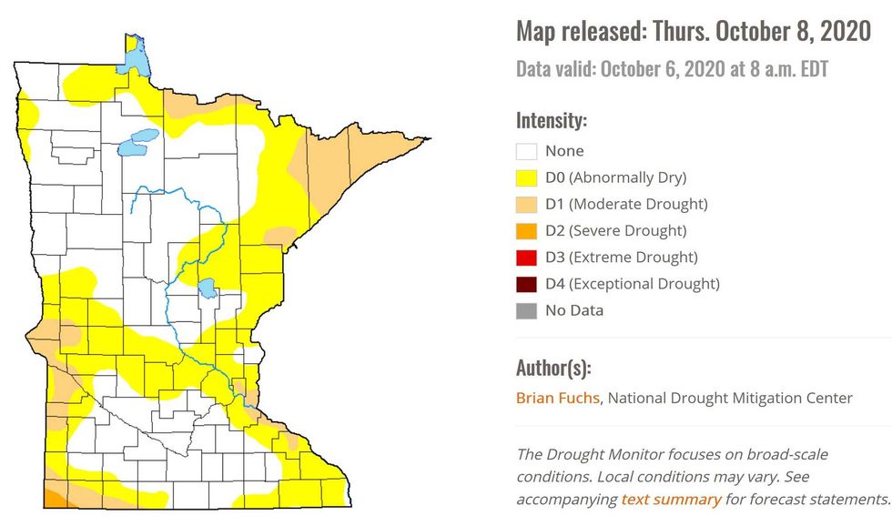
Moderate Drought. Pockets of moderate drought are now showing up in the east metro, the Minnesota Arrowhead and far southwestern Minnesota. There's even a small sliver of severe drought southwest of Worthington.
Map credit: U.S. Drought Monitor
 Drought Map(Photo Courtesy of the U.S. Drought Monitor)
9th Driest Stretch Since September 1 for the Twin Cities? The National Weather Service tweet above captures just how unusual this dry spell is. At the rate we're going, looking at the period from September 1 through October 10, this is the driest such period in the Twin Cities since 2012.
Rainfall Since September 1. Only .90" of rain has fallen on the Twin Cities, and with the exception of far southeastern Minnesota most of the state has experienced unusual dryness over the last 6 weeks. Map credit: Praedictix.
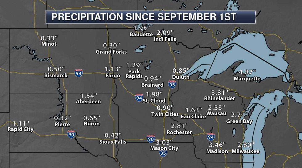 Precipitation since September 1st(Photo Courtesty of Praedictix)
Rainfall Departure Since September 1. The Twin Cities metro is running a nearly 3" rainfall deficit since September 1, but over 3" in Brainerd and 4" at Duluth. All the big, sloppy, wet storms have sailed well south of Minnesota and Wisconsin in recent weeks.
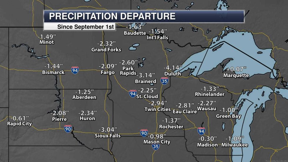 Rainfall Departure since September 1st(Photo Courtesy of Praedictix)
Severe Risk Late Sunday. A dry Saturday gives way to a growing chance of showers and T-storms during the late PM hours on Sunday, and according to NOAA's Storm Prediction Center (SPC) a few storms may turn severe by late Sunday afternoon, especially central and western Minnesota. We will see rain Sunday night; latest models hinting at around a half inch of moisture for most towns. Not enough to dig us out of this dry rut, but it may help a little in the short term. Map credit: Twin Cities National Weather Service.
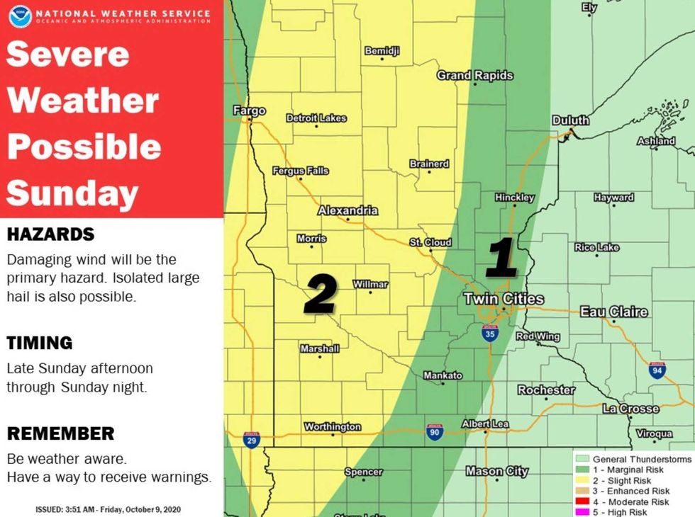 Sunday Severe Risk(Photo Courtesy of National Weather Service Twin Cities)
Peaking Fall Color. Roughly the northern half of Minnesota and Wisconsin is already past-peak. My sense is that this will be the weekend to enjoy peaking fall color in and around the Twin Cities. Southeastern Minnesota color will probably peak next week. Enjoy the free show! Graphic credit: Twin Cities National Weather Service.
The weather has been amazing in recent weeks - Minnesota has lucked out in terms of an unusual number of sunny days. But a lack of storms is impacting everything from fire risk to stream flow to soil moisture. My hope is that we pick up a few more significant storms in the weeks to come, recharging moisture levels before the Big Freeze sets in.
By the way, today's all-time record high in the Twin Cities is 86F. We will come very close to tying or breaking that record this afternoon.