Another suboptimal spring across the Upper Midwest, which appears to be a trend, at least in the last decade or so.
What is going on? If the planet is warming (it is) why are we seeing colder air and more slush in late winter and early spring, specifically March and April?
For the record, April brought 3.8" of snow (MSP International - more for the suburbs) and was 1.3F colder than average. Most of the month was chilly, but four days of 80s in a row sort of skewed the numbers. Increasingly, there is no such thing as an average April.
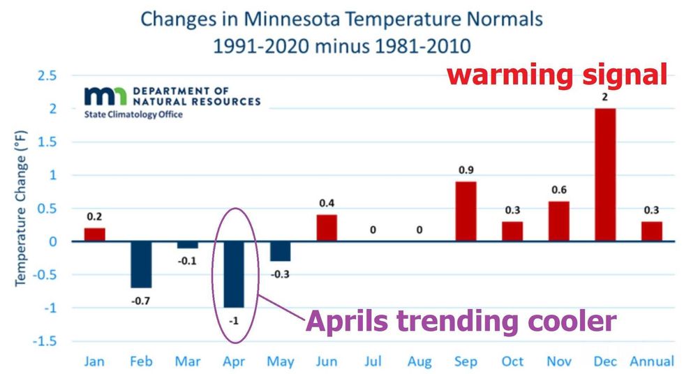 Changes in Minnesota's normal temperatures shows April is lower than any other month.Credit: Dr. Kenny Blumenfeld and the Minnesota State Climatology Office
The warming signal in the Twin Cities is most pronounced in autumn and early winter, but a comparison of the most recent 30-year climate data for MSP with the 1981-2010 numbers shows something interesting: February through May are running colder, especially April. How can this be?
 Late March, 2012 we were already seeing blooming plant life.(Audacy / Paul Douglas)
First, a caveat: this is a relatively recent phenomenon. I remember plants in full bloom in late March of 2012 (photo above).
According to meteorologist and climatologist Dr. Mark Seeley, the springs of 2013, 2014, 2018 and 2022 are among the coldest of the last 50 years in the Twin Cities. According to Seeley, since 2012 we have experienced eight wetter than normal springs, six of which have brought above normal snowfall.
And this trend holds up across Wisconsin, Minnesota and North Dakota.
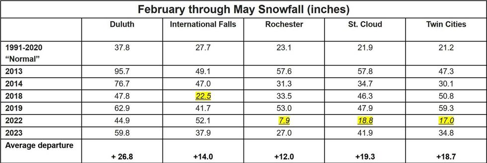 February through May snowfall each year from 2013-20-23 compared to the 30-year average.(Date/Graphic: Minnesota State Climatology Office)
Data: Minnesota State Climatology Office
Minnesota Senior Climatologist Dr. Kenny Blumenfeld confirms the trends, and adds that February through May snowfall is running 12-26 inches more than the 30-year average, from 1991-2020.
"There has indeed been a tendency to have cool or cold, and often very snowy late-winter/spring periods here in Minnesota," adds Blumenfeld
Blumenfeld says perspective is critical.
"Our late-winter/spring period is still warmer than those of 50+ years ago, and at times it has been warm in a way we never really experienced (or at least recorded),” Blumenfeld explained. “But the last 10-plus years have been cooler than the previous couple of decades."
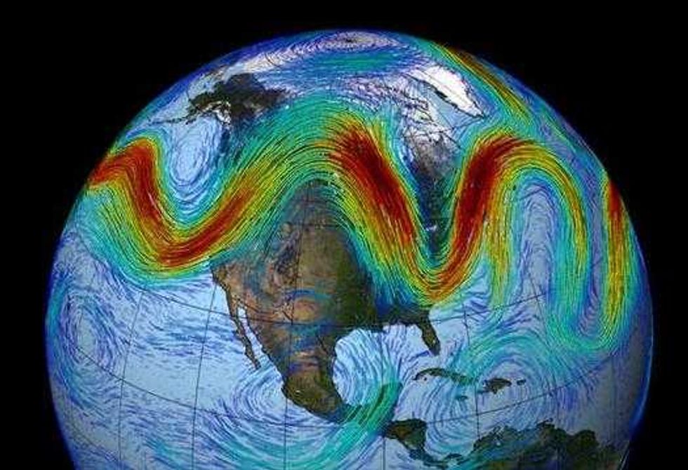 Is a wavier jet stream to blame?Image Credit: NASA
Is a wavier jet stream to blame?
What's going on? Proving cause and effect is impossible with the atmosphere, but there are a myriad of factors to consider, including natural variability. This could just be "normal weather", believe it or not. There is a reason why we use 30 years for climate data. 10 years of chilly springs may be more fluke than trend.
We are coming out of a La Nina cool phase in the Pacific, which correlates with colder winters for the Upper Midwest. Other natural cycles and oscillations may be in play, including the Arctic Oscillation (AO).
It's far from settled science, but a handful of climate scientists are linking recent chilly springs to "Arctic Amplification" and changes in the configuration of the jet stream.
The arctic is warming two to three times faster than the rest of the planet, and this may be impacting the north-south temperature gradient that drives the jet stream, the high-speed river of air snaking around the Northern Hemisphere, making it wavier or loopier, displacing chilly air farther south - with more (real) cold fronts for Minnesota and Wisconsin in March and April. It's an interesting theory - we just need more years of data to say so with greater confidence.
Bottom line: The short-term cooling trend during spring may be a fluke, an atmospheric hiccup, or possibly linked to rapid warming north of Minnesota. As is so often the case, we don't know what we don't know.
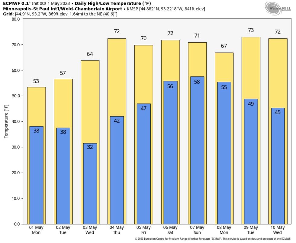 Spring may finally "stick" this time. The European Model is showing real signs of late spring weather.(ECMWF courtesy of Weatherbell.com)
Spring may finally "stick" this time
After a fairly-tortured spring, some temperature relief is finally coming into view, and I suspect this time around we will hang on to relative warmth. The European model prints out consistent 60s, even a few days of low 70s looking out the next two weeks as the pattern finally evolves and maddeningly-persistent pockets of cold air retreat northward.
Minnesotans earn their summers. Before long we'll be whining about bugs, humidity and washed-out weekends. Wait for it.