It was a great weekend and it is shaping up to be a very nice summer week. Enjoy it because the return of super-heated late summer weather is knocking on the door according to WCCO Chief Meteorologist Paul Douglas.
"Low to mid-80's much of this week, fairly comfortable into Thursday, and then the mercury takes off," says Douglas. "It's going to be a stinking-hot Labor Day Weekend."
Douglas says a lot of Minnesota could be at or above 90 through the middle of next week, which of course is September. Fall has been put on notice because Labor Day is not going to be the end of summer.
"Already 27 days at or above 90, at the rate we're going we'll be in the thirties, maybe 30-35 days at 90 by the end of September," Douglas says.
If you're wondering, the record for 90-degree days in the Twin Cities? An amazing 44 in 1988 which we won't approach. There's an outside chance we could get to second which was 36 days in 1936. Labor Day Weekend will almost surely move us into the top ten.
It's also a dry forecast and Douglas says there is nothing resembling rain at all in the extended outlook. There's a very small chance of a thundershower Monday evening or Monday night, but don't expect anything widespread.
"I think we'll have a summery hangover well into September and October," Douglas predicts. "I wouldn't be surprised to see 90s into late-September this year."
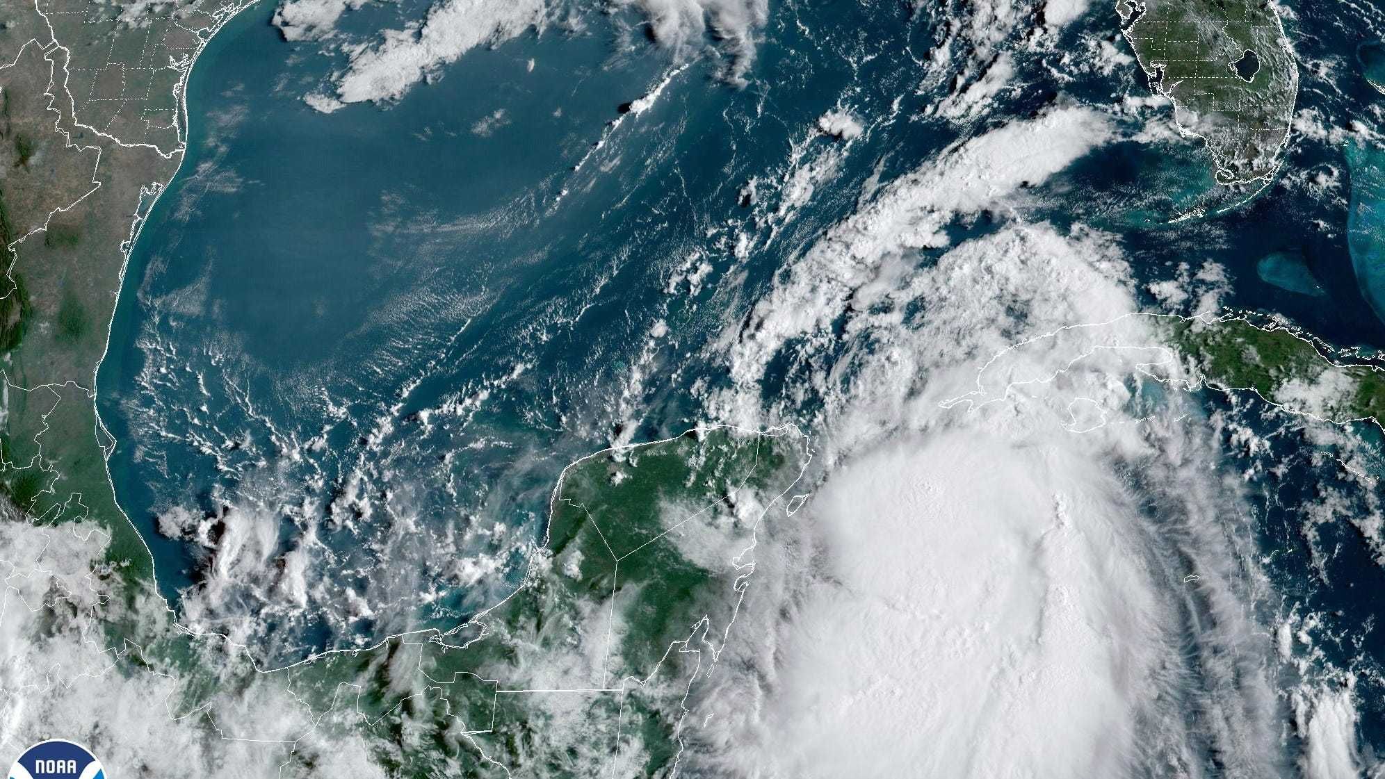
First Major Hurricane Heading for Florida
Tropical Storm Idalia intensified and was expected to be a major hurricane when it reaches Florida's Gulf Coast later this week. It's intensifying quickly says Douglas who notes that the Gulf of Mexico is basically "bath water" right now.
"Water temperatures are in the 90s and that could mean rapid intensification," Douglas explained. "The models shifting the track a little farther east. It could be closer to Tampa-St. Pete than a lot of folks would like. We'll see, but I have a bad feeling about Idalia."
That area has seen some of the hottest ocean temperatures on record, with some over 5 degrees Fahrenheit above average and even some triple digit water readings off the tip of Florida, which scientists say may be unprecedented.
Those high temperatures are devastating for wildlife and coral, but also super fuel for hurricanes.
Florida Governor Ron DeSantis warned of a “major impact” to the state, noting that what was originally forecast to be nothing stronger than a tropical storm was now predicted to become a Category 3 hurricane.
This might only be the beginning for this hurricane season. Sea surface temperatures worldwide have broken monthly records for heat since April, according to NOAA. And temperatures in the north Atlantic Ocean are off the charts — as much as 9 to 11 degrees Fahrenheit (5 to 6 degrees Celsius) warmer than normal in some spots near Newfoundland, Canada.
FORECAST
Monday- Warm, high 86 with a slight chance of a popup storm Monday night.
Tuesday- Sunny, slightly cooler. High 82, low 65.
Wednesday- Sunny and perfect. High 81, low 61.
Thursday- Sunny and windy. High 84, low 64, winds up to 30 mph.
Friday- Warming up with some potential thunderstorms north. High 91, low 68.
Saturday- Warm sun. High 90, low 64.
Sunday- July meets September. Hot sun. High 92, low 67.