


Just two days after Christmas and for some it's finally time to test out those new skates that were under the tree. However, it's not exactly a winter wonderland out there.
The snow that fell last week is still hanging around, barely. But it is melting by the hour because of warmer temperatures and rain.
"If there's a wrinkle of good news, it does stay mild tonight, so we're not gonna be dealing with a hockey rink on the highways tomorrow morning," says WCCO-TV Chief Meteorologist Chris Shaffer. "And then maybe a few snowflakes mix in early tomorrow, mainly north of the Twin Cities. Not expecting any accumulation from that at all."
Temperatures in the Twin Cities are expected to dip down into the teens again by the end next week just in time for January.
"This is not fun. I mean, think of all the hockey rinks, the city rinks out there all over the state that are maintained, that are just gonna get this mini lake formed on top of it with the rainfall that's coming," Shaffer says. "Then that freezes. So you kind of have two layers of ice, which is gross to skate on. You know that you get the air bubbles, you poke through when you're trying to skate."
It's true for those trying to ice fish too. Even on Thursday, the ice was still picture perfect for ice fishing on frozen Lake Nokomis in Minneapolis.
"There was about ten of them right out here from the boat launch," said Andrew Ranning said Friday morning. "And there was a couple over by the beach and then there was a couple over by the Cedar Avenue Bridge. I counted about, like I said, 15 ice fishing shacks."
But Friday, anyone walking or driving by the lake can count the number of ice shacks on one hand. And the two that are out there are surrounded by countless pools of standing water.
"Global warming, the weather doesn't stay cold like it used to do, like it like it was years ago," Ranning says. "It's almost like it's spring weather. So yeah, it just doesn't seem like winter."
Ranning's statement about that warming is backed by data. Winter warming rates in particular have risen even more sharply in recent decades across Minnesota. From 1970 through 2021, average daily winter low temperatures rose more than 15 times faster than average daily summer high temperatures. The frequencies of -35° F readings in northern Minnesota and -25° F readings in the south have fallen by up to 90%. We just don’t get as cold as we once did, and even though Minnesota always will see periodic severe cold spells, the long-term decline in cold extremes is all but guaranteed to continue according to the Minnesota Climatology Office.
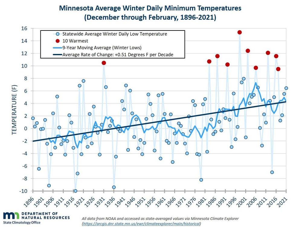 Graph from the Minnesota DNR shows a sharp increase in winter minimum temperatures since 1896.(Minnesota Department of Natural Resources)
There's still about 4 inches of ice on Lake Nokomis and most of the metro-area lakes are stills safe for fishing. Yes, winter will be back and yes, the ice will freeze again. But the rain and slush makes it far less than ideal for either fishing or ice skating
Friday, Minnesotans across the entire state, plus in northern Wisconsin, were greeted by a dense fog advisory. Even though it expires at noon Friday, there's still plenty of gloom in the air. Rain and patchy fog will continue all day Friday and into Saturday before it finally shows a few signs of clearing.
Temperatures will remain in the 30s all weekend with a few 40s possible. There's another chance of some rain and mixed precipitation on Monday before winter finally makes a comeback. By Tuesday highs will be in the upper-20s. Expect a high of 23 on New Year's Day before we drop into the teens by the end of the week.


