You knew it was coming. Minnesota's traditional March tournament storm is coming this week although for most of the metro, it will end up being mostly a rain event. While Monday is shaping up to be a beautiful day in the 50s, the other shoe drops Tuesday and Wednesday.
The National Weather Service does have a Winter Storm Watch out for parts of Minnesota and Western Wisconsin as Tuesday night into Wednesday should see some March snow according to WCCO Chief Meteorologist Chris Shaffer. But before that? It's going to be wet.
"It's gonna start sprinkling overnight," says Shaffer on the WCCO Morning News with Vineeta Sawkar. "Some people are concerned about tomorrow morning's commute. Don't be because the temperature only backs off to 43. So it's all rain. Nothing will be slick out there. During the day tomorrow, it's just a steady rain, nothing severe, no downpours, but just a rainy, gloomy kind of day with a high of 46."
Overnight on Tuesday is when it starts to shift Shaffer explains. He says snow amounts won't be much but what comes with that snow will get your attention.
"You'll notice the wind starting to pick up later tomorrow evening," he says. "It's Tuesday night around midnight or so where the National Weather Service has put out the Winter Storm Watch tomorrow night into Wednesday afternoon, and it basically covers southern Minnesota into Wisconsin and clips Dakota and Washington Counties right now."
Shaffer says the snow is likely only in the 1-3 inch range, but the big concern isn't the heavy snow, it's the wind.
"The wind will be coming 15 to 25 MPH from the north," Shaffer says. "So where it snows, there could be whiteout conditions, possible blizzard conditions. Poor visibility, mainly, during the overnight."
He says that means a tricky commute Wednesday.
That travel's gonna be rough if you're a very early riser Wednesday morning," Shaffer explained. "It'll be interesting because it's only 1 to 3 inches of snow, better chance of 1, say, in Brooklyn Park and 3, say down in Red Wing. That's the angle that's coming up, so we'll keep a close eye on it. A lot will melt on contact, but yes, I would plan on a longer commute on Wednesday morning."
It's also going to be that wet, heavy, typical March snow which could keep the blowing to a minimum, especially in the metro area. But expect it to be very sloppy.
If you're coming to the Twin Cities from the north for the Boy's State High School Hockey tournament? Shaffer says don't sweat it since this storm is coming up from the south and won't impact travel at all north of the Twin Cities.
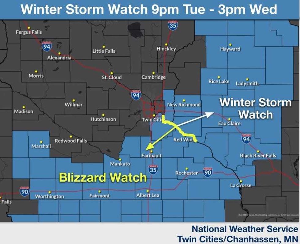 Where the watches have been issues by the NWS.(National Weather Service Twin Cities / NOAA)
WINTER STORM WATCH TUESDAY EVENING THROUGH WEDNESDAY
* WHAT...Blizzard conditions possible. Total snow accumulations between 4 and 8 inches possible in some areas, especially south and east of the Twin Cities. Winds could gust as high as 50 mph.
* WHERE...Dakota, Blue Earth, Faribault, Freeborn, Le Sueur, Martin, Rice, Steele, Waseca, Watonwan, and Goodhue Counties.
* IMPACTS...Visibilities may drop below 1/4 mile due to falling and blowing snow. The strong winds and weight of snow on tree limbs may down power lines and could cause sporadic power outages. Whiteout conditions are possible and may make travel treacherous and potentially life-threatening. Plan on slippery road conditions. The hazardous conditions could impact the Wednesday morning commute.
* ADDITIONAL DETAILS...Rain is expected Tuesday evening before transitioning over to all snowfall late Tuesday evening to early overnight. The heaviest snowfall is forecast Tuesday night through Wednesday morning.