


A winter weather advisory goes into effect later Friday, but don't panic. It's not expected to be a really bad storm according to WCCO-TV chief meteorologist Chris Shaffer.
He says snow is coming, but not too much.
"The mix arrives overnight tonight and I think initially it's snow-sleet, so not a huge concern," Shaffer explains. "It would be pretty light and probably not arriving until after midnight. So commence with all your Friday plans. Commence with all your Friday night plans. It's while we're sleeping tonight that that mix comes up from the south."
Shaffer says this storm is more of a concern for the Twin Cities and southern Minnesota before pushing into western Wisconsin.
Because the storm is coming from warm air high in the atmosphere, the ground temperature will rise so much of what falls isn't expected to stick.
"What's happening, is it's a big slug of warm air higher up in the atmosphere," Shaffer told Vineeta Sawkar on the WCCO Morning News. "So our temperatures even at the ground are gonna warm overnight. We should make it up to about 30 (Saturday) afternoon. And again, it will be light, but we could see some light flurries tomorrow and there could be a little window of light freezing rain."
After a few days of really cold temps and wind chills, the high Saturday should be in the 30s which should feel better across the state. Sunday and Monday should have highs in the mid-30s.
The long range forecast is now hinting at a thaw over Christmas and it's looking very unlikely the Twin Cities will have a "white Christmas".
That white Christmas in Minnesota is defined as having one inch of snow on the ground. There are a few spots in far northern Minnesota where there's a 100% chance of a white Christmas but it's actually a pretty common occurrence in the Twin Cities. About 71% of the years that have been tracked have that one inch of snow on the ground.
If you think it's been a long time since the Twin Cities saw a big dump of snow, you're right. The last time we had 10"+ snow in one day at MSP is now over three years ago, December 10, 2021.
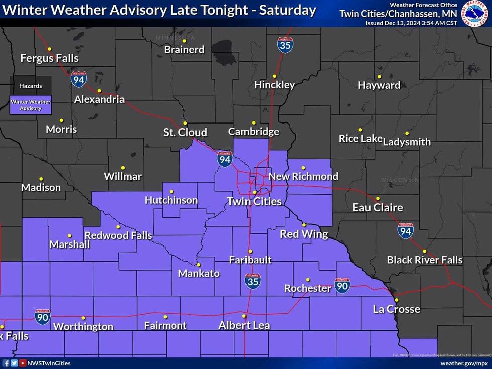 An icy wintry mix of snow, sleet, and freezing drizzle develops tonight through Saturday. A Winter Weather Advisory has been issued for much of central and southern MN where icy roads & untreated surfaces are expected.(Courtesy of the National Weather Service- Twin Cities)
In effect from midnight Friday to 6:00 p.m. Saturday.
* WHAT...Mixed precipitation expected. Total snow accumulations up to one inch, sleet accumulations up to one tenth of an inch, and ice accumulations up to one tenth of an inch.
* WHERE...Wright, Anoka, Carver, Dakota, Hennepin, Ramsey, Scott, Washington, Freeborn, Le Sueur, Rice, Steele, Waseca, and Goodhue Counties.
* IMPACTS...Plan on slippery road conditions.
Friday: light precipitation will move into southern Minnesota and spread into central and eastern MN by sunrise.
Saturday: A mix of snow and sleet is expected initially, but it will transition to a mix of freezing rain and snow through Saturday morning.
The main concern is travel impacts from a glazing of ice and slick roads. Southeast winds will be light, around 10 to 15 mph, and any icing amounts should be less than a tenth of an inch.
The National Weather Service advisory does not anticipate impacts to powerlines.


