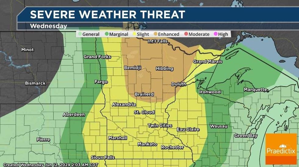
It could get a little stormy later Wednesday morning and again during the afternoon hours with most of Minnesota and western Wisconsin in the slight risk category for severe storms.
"Normally we get our big storms around the dinner hour," explains WCCO Radio Chief Meteorologist Paul Douglas. "This time it's going to be before lunchtime, this first wave coming in, then maybe a second line late this afternoon. Most of us will not see severe weather, but a few communities will get blasted."
There have been a few warnings in far western and southwestern Minnesota early Wednesday with Kandiyohi and Yellow Medicine Counties among those seeing early-morning storms.
As for the timing in the Twin Cities?
"It's going to come through later this morning into the midday hours," Douglas says. "And yes, there could be some small hail. There will be some severe weather. A little unusual, getting severe weather in the morning, but it happens if you have the atmosphere of dynamics than we do today."
Tthe best window for the stronger storms will be later this afternoon into this evening and the threat is actually greater in north central and northern Minnesota. From St. Cloud and Little Falls up towards Cloquet and Duluth stand the best chance of seeing severe storms.
"Some damaging winds, maybe two inch diameter hail in a few spots," he predicts. "So be careful out there. I do expect some watches and warnings."
Large hail and damaging winds is likely with the strongest storms. A tornado also can't be ruled out says the Twin Cities National Weather Service.
As for the Twins game? They play at Target Field just after noon and Douglas says he thinks a rain delay could be coming.
"I think there will be issues he says. "Hopefully they get it in. Maybe there'll be a rain delay. But there will be a few hours of heavy rain, midday today. It may brighten up a bit after 1:00 or 2:00. But it'll be hit-and-miss."
 Severe weather risk Wednesday in Minnesota(Praedictix / Paul Douglas)
Douglas says once the storms move through, we'll clear out and make way for a nice end of the week before more rain arrives this weekend.
"Back into the soup, more showers and heavy storms Saturday into Sunday morning," Douglas says. "The models print out another one to three inches of rain by next Wednesday, some spots getting five inches. So man, no end to this active, wet pattern that we've been in. We're going to be right on the edge of 90-degree heat and that's going to keep us thundery through next week."