We needed the rain. Even if it put a damper on your Mother’s Day plan, although by Sunday afternoon it was pretty pleasant out there.
The same can’t be said of spots in southern Minnesota where the rain never let up and has led to flooding and even landslides in some spots.
WCCO Chief Meteorologist Paul Douglas takes you through what was, and what will be this week which is shaping up as the nicest of the year so far!
Flooding
“We did get ample rain over the weekend, close to an inch for some southern and western suburbs of the Twin Cities,” says Douglas.
That’s good news as we are still recovering from a couple of years of well below normal precipitation. The ground still needs to soak up some water even if that means your lawn just exploded in green (or yellow dandelions).
But to the south, it was a different story.
“The most (rain) I saw, close to eight, eight, inches from the weekend storm,” explains Douglas about the Mankato area. “Wave after wave of showers and storms down in Comfrey, where many rivers are still out of their banks. More streams than rivers, but definitely some flash flooding south of the Twin Cities over the weekend.”
That torrential rain triggered a mudslide that closed a state highway early Sunday. The Minnesota Department of Transportation reported at about 5:30 a.m. Sunday that State Highway 68 was closed south of Courtland due to a “sizeable mudslide” across the driving lanes. That area should be open again but they suggest proceeding with caution anywhere near the Minnesota River in that part of the state.
Both Minnesota highways 19 and 93 in the Le Seuer area are closed due to river flooding according to MnDOT Monday.
Beautiful Week Ahead
After the rain, the sun did pop out later on the day Sunday which is a preview of what we’ll see Monday and beyond.
“If you missed out on the fun yesterday afternoon, another shot today,” says Douglas. “Just a glorious day. I feel like a weather person in San Diego. I should be talking about the tanning index and the surf report. We're looking at mid-seventies today, blue sky, 80 tomorrow, and low humidity.”
As we get to midweek there will be a slight change Douglas says.
“Wednesday still looks nice, partly sunny. The only chance of rain really late Thursday into Friday,” predicts Douglas. “A few showers, maybe a clap of thunder. It cools off a little by the end of the week, but back up into the seventies this weekend.”
And it is going to last.
“I see seventies next week, no stinking hot eighties or nineties,” Douglas told Vineeta Sawkar on the WCCO Morning News. “Just beautiful spring weather. The weather we should have had back in April we're getting now and it looks fairly mild and fairly dry looking out the next two weeks. So I'm okay with that.”
With lows staying in the upper forties and low fifties, it is officially growing season in Minnesota.
Still Dry North
There's actually a fairly significant fire threat over northern Minnesota.
After a few small fires across northern Minnesota (including a prescribed fire that got out of its boundary) the past few days, the fire weather threat looks to increase as we head into Monday. A Fire Weather Watch is in place, as expected warm temperatures, gusty west winds up to 25 mph, and low humidity values would allow any fires that spark to quickly spread.
“Combination of low humidity and gusty winds,” Douglas says.
“Not so much an issue here from the metro on south.”
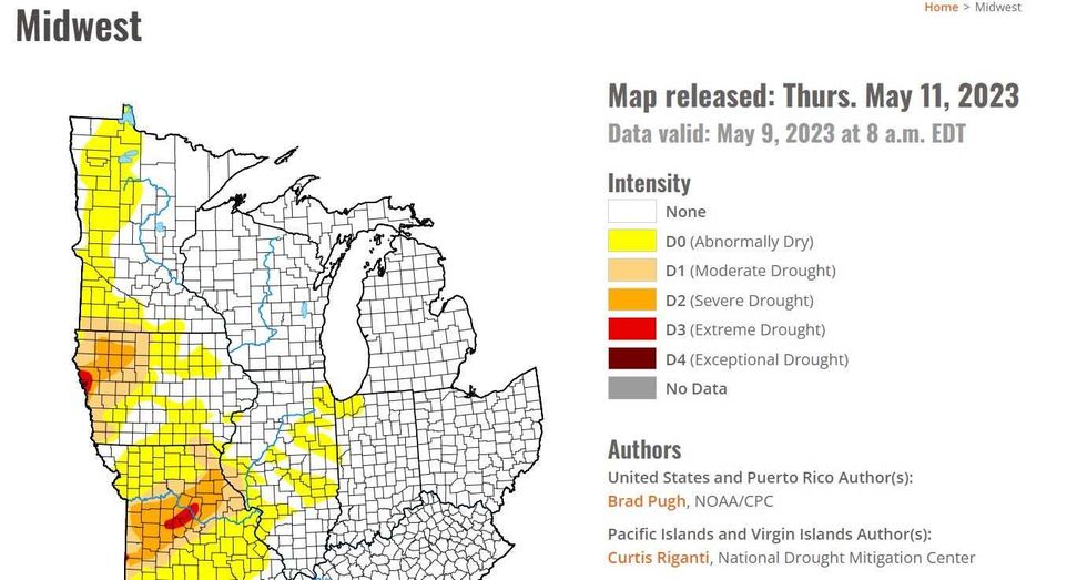 The U.S. Drought Monitor shows abnormally dry conditions still in parts of western and northern Minnesota (in yellow).(U.S. Drought Monitor, NOAA)
In fact, the western third of Minnesota is still listed as “Abnormally Dry” by the U.S. Drought Monitor (May 9th).
FORECAST
Monday: Sunny and beautiful. High 75, low 49.
Tuesday: Blue sky and low humidity. High 79, low 55.
Wednesday: A few clouds, still pleasant. High 74, low 51.
Thursday: Showers likely, few T-storms. High 68, low 61.
Friday: Windy and cool, few showers. High 61, low 45. Wind NW 15-30 mph.
Saturday: Sunny and pleasant. High 71, low 50.
Sunday: Sunny and milder. High 75, low 53.