![Livonia woman comes face to face with suspected burglar: it's an 'Oh my God moment' [VIDEO]](https://www.audacy.com/media-library/man-suspected-of-trying-to-break-into-livonia-home.jpg?id=66730830&width=1245&height=700&coordinates=0%2C29%2C0%2C29)

(WWJ) - Metro Detroit missed out an a massive, quick-hitting winter storm impacting the Northeast this weekend -- yet another storm on its heels is expected to take a different path and strike nearly 30 states to start off the work week, including almost all of Michigan.
Both AccuWeather and National Weather Service meteorologists have been keeping tabs on a second major cross-country storm that is expected to gain strength and size as it sweeps into the Great Lakes region Tuesday into Wednesday.
 AccuWeather
While weather experts say the forecast is still up in the air over whether Metro Detroit will see all-snow, all-rain or a change-over event, there is stronger confidence that its impacts will be felt in Lansing, Grand Rapids, Midland, Gaylord and other cities to the north.
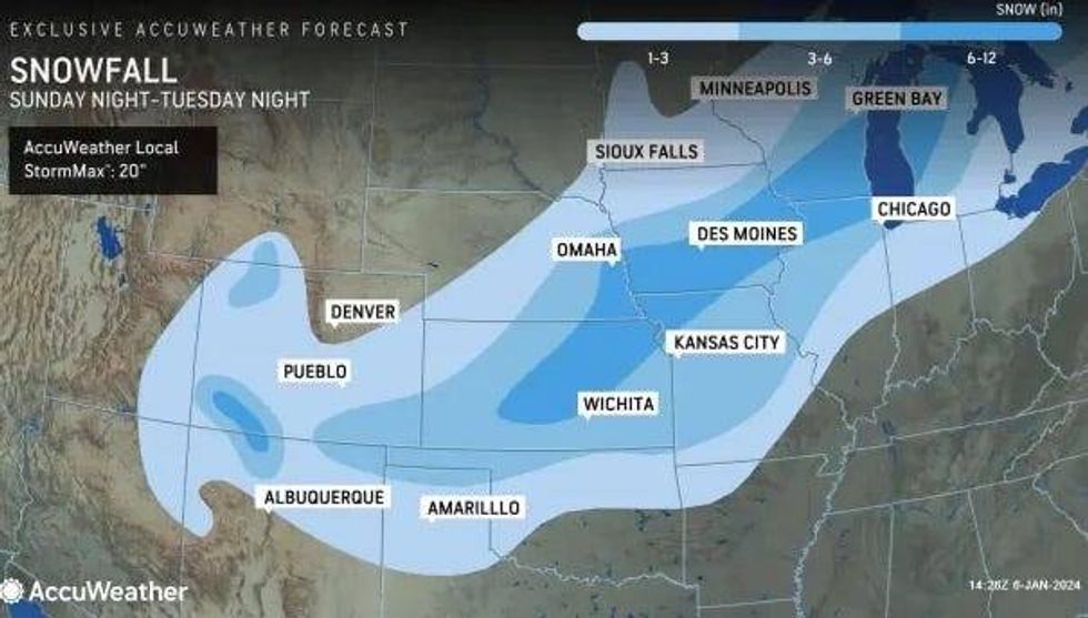
"The heaviest snow, with 6-12 inches and an AccuWeather Local StormMax of 20 inches, will extend from central Kansas to northern Michigan," AccuWeather said.
Grand Rapids is smack dab in the middle of the heavy snow and highly disruptive travel zone, along with other Midwest cities in Kansas, Nebraska, Wisconsin and Illinois.
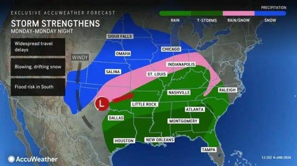
According to the National Weather Service in Detroit, the strong low pressure system will not only bring significant winter precipitation to Lower Michigan, but also the possibility of strong winds.
AccuWeather experts agreed, stating the blowing winds could be strong enough to bring on blizzard conditions in some areas.
"As the storm strengthens within this zone, winds will increase and average 20-40 mph with gusts from 40-60 mph and locally stronger," AccuWeather stated. "Blowing and drifting snow will become a problem in open areas. There is the potential for localized blizzard conditions, where the snow remains or becomes dry and powdery over portions of the central and southern Plains and the Great Lakes region."
Back in Southeast Michigan, forecasters say residents should still be prepared for a major winter storm because of the fluctuating temperatures which could result in precipitation jumping back and forth from heavy rain to wet snow.
"This is most likely from portions of central Missouri to central Illinois, northern Indiana, northwestern Ohio and the southeastern part of the Lower Michigan Peninsula. The metro areas of St. Louis and Detroit may fall within this weather battle zone where cold air and warm air exchange hands," meteorologists said.
NWS said data so far suggests the metro area could see a quick accumulation snow before it switches over to rain. The northern suburbs are expected to see more snow while Downriver communities will see higher rain chances.
 AccuWeather
Both weather sites informed Michiganders to stay up to date for the latest changes in the forecast as impact levels may increase when confidence in the forecast also increases.
Meteorologists are also keeping an eye on a third storm that could impact Michigan next weekend as winter appears to be firing on all cylinders to start 2024.
"Early indications are that Arctic air will surge southward from the Northwest to the North Central states as a new storm rolls in from the Pacific Ocean," AccuWeather said. "This new storm, slated to hit the middle of the nation during the second weekend of January, could evolve into one of the most intense snowstorms in recent years from parts of the Plains to the Midwest. Depending on the storm's track and strength, travel-stopping and dangerous blizzard conditions may once again unfold over multiple states from Texas to Michigan next weekend."
Updates on the storm for the start of the week and next weekend will be available on WWJ with traffic and weather on the :08s.