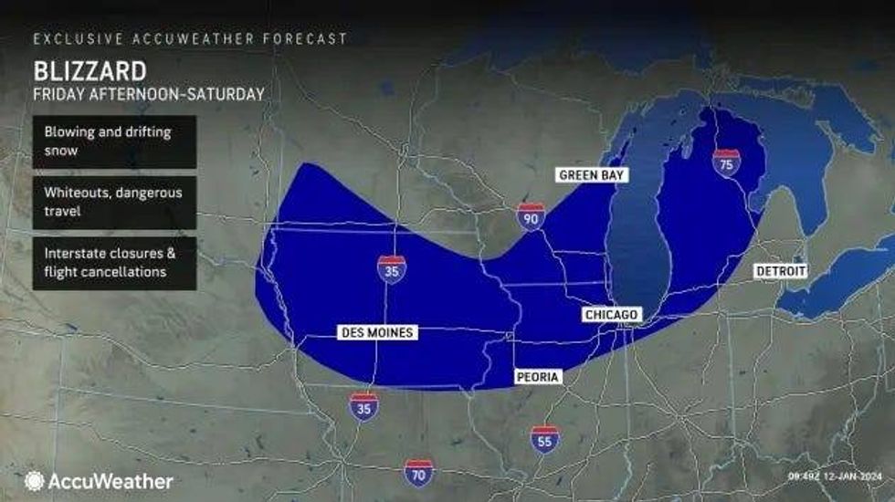
DETROIT (WWJ) - Time is running out for Michiganders to prepare for a monster storm that has set off blizzard and winter storm warnings and winter weather advisories across every county in the Upper and Lower Peninsula as it bears down on the region through the weekend.
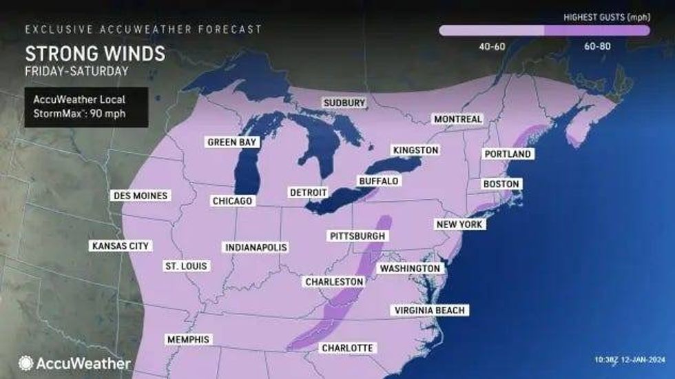
WWJ's AccuWeather meteorologist Dean DeVore said the storm will thrash a large swath of the state with at least a foot or more of snow, frigid Arctic air and brutal winds gusting 40 to 60 mph that could create dangerous and life-threatening blizzard conditions for people and animals caught outside.
"We've got a multi-faceted one," DeVore said of the storm during a 6 a.m. update on Friday morning. "It's thumping in Chicago already and it's starting to get into some of those areas in Southwest Michigan."
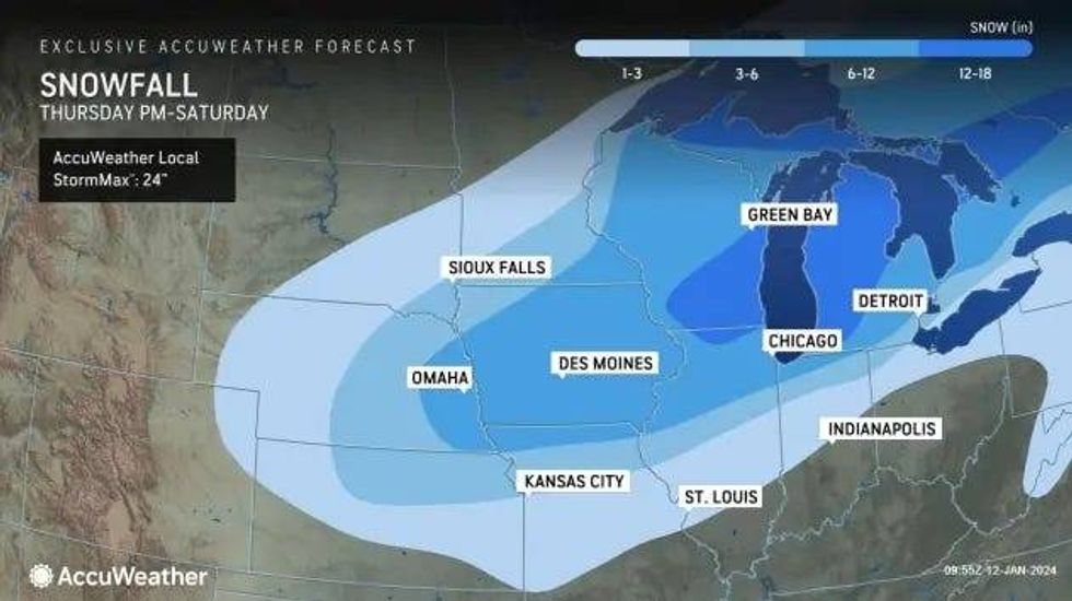
A Winter Weather Advisory for Huron, Tuscola, Sanilac, Shiawassee, Genesee, Lapeer, Livingston, Oakland and Washtenaw counties has been posted from 1 p.m. Friday until 7 p.m. Saturday with forecasted snow accumulations of 3 to 6 inches and winds gusting as high as 50 mph.
A Winter Weather Advisory has also been posted for Macomb, Wayne, Lenawee and Monroe Counties from 1 p.m. Friday until 7 p.m. Saturday, with a little less snow -- accumulations of 1 to 4 inches == and winds gusts up to 50 mph possible.
All of the U.P. and most of central, south central, southwest and west central Michigan are under a Winter Storm Warning from 10 a.m. Friday until 7 p.m. Saturday with heavy snow accumulations of 8 to 13 inches expected and fierce wind gusts of over 50 mph creating hazardous or "perhaps impossible" travel by Friday night.
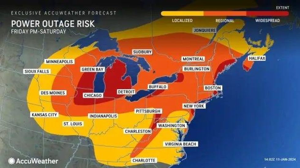
"Widespread blowing snow could significantly reduce visibility," the NWS warned. "The hazardous conditions will impact the Friday evening commute. Gusty winds could bring down tree branches and cause power outages."
Otsego, Montmorency, Crawford, Oscoda and Ogemaw Counties in Lower Northern Michigan are expected to see the worst conditions of the storm, the NWS said, with a Blizzard Warning in effect from 5 p.m. Friday until 7 p.m. Saturday. Experts strongly urged residents to restrict travel to emergencies only as up to 18 inches of snow will bury some areas while sustained winds of 35 to 50 mph are expected to howl overnight.
The storm is forecasted to become stronger and colder as it undergoes bombogenesis, or rapid intensification, and emerges as a "bomb cyclone," AccuWeather experts warn.
 AccuWeather
"The official designation for such a storm occurs when the barometric pressure drops 0.71 of an inch of mercury (24 millibars) or more within 24 hours," AccuWeather experts said. "The faster that the pressure drops, the faster that winds rush in to replace the air. In effect, the storm becomes a massive wind machine that can cause power outages and property damage and create near-zero visibility in snow and blowing snow (blizzard)."
While the storm will thrash West and Lower Northern Michigan the hardest, its affects will still be felt throughout Metro Detroit.
DeVore said Southeast Michigan will start to see precipitation from the storm by mid to late afternoon on Friday get to us here by mid to late afternoon on Friday.
"Now, I think what I'm seeing happening in Chicago is what I think happens here where it thumps us with snow initially and then we get a mix in, even a change over, to rain from the city southward, especially near the rivers and the lakes here in that far southeastern side," DeVore explained. "And then as that area of low pressure continues to move over us tonight into tomorrow morning, we'll flip back over to snow everywhere."
 AccuWeather
DeVore added that while estimated snow totals for Metro Detroit have been adjusted, he warned that residents shouldn't get "caught up" on the amounts as it "really doesn't speak to what's gonna be happening once we get into the latter part of tonight into tomorrow."
At this time, Downriver communities could see an inch to 3 inches of snow while in and around Detroit will see 3 to 6 inches of accumulation. Areas north of I-69 are expected to see 6 to 12 inches.
"But even with the lesser amounts, once we get into that phase of the storm later on tonight into tomorrow morning, the wind is gonna be howling gusting 40 to 50 MPH, visibility near zero near blizzard conditions and a rapid freeze up as temperatures plunge tonight into tomorrow and then bitterly cold," DeVore warned. "I just don't think we're prepared for how cold this is going to be."
 AccuWeather
 AccuWeather
The NWS backed DeVore's forecast, stating very strong winds would bring in a blast of Arctic air behind the system, sending wind chill values close to zero.
According to AccuWeather, anyone who finds themselves outdoors during the storm would be at risk for hypothermia and frostbite as peak winds whip through.
The cold weather threat will continue to grip the state even after the storm moves out.
"Sunday, Monday, Tuesday, highs only in the low to mid-teens and Real Feels a lot of those times near or below zero," DeVore warned.
The frigid temperatures along with strong winds will lead to rapid ice build-up along the Great Lakes and freezing over wash and spray along shorelines. The Arctic blast is also predicted to produce bands of heavy lake-effect snow immediately after the storm.
A Storm Warning and Heavy Freezing Spray Warning has been issued by the NWS for the entire American side of Lake Superior beginning 1 p.m. Friday until 7 p.m. on Saturday, urgently warning sailors to remain at port, alter their course or conduct mitigation for severe conditions as the storm moves through.
Forecasters say northeast winds will blow 35 to 45 knots with gusts up to 55 knots and waves 18 to 23 feet expected. Heavy freezing spray at a rate of 2 cm per hour or greater is expected and can rapidly accumulate on vessels.
"Operating a vessel in heavy freezing spray is hazardous," the NWS warned. "Freezing spray may render mechanical and electronic components inoperative. Rapid ice accretion on decks and superstructures may result in a catastrophic loss of stability. Very strong winds will cause hazardous waves which could capsize or damage vessels and reduce visibility."
Experts urged anyone with travel plans check their local forecasts for their destination, as well as keep up-to-date on any changes, as conditions will vary significantly during the storm.
Don't miss a thing! Stay with WWJ for traffic and weather updates, every 10 minutes on the 8s, listen anytime on the free Audacy app, or tell Alexa: "Play WWJ nine-fifty."