
DETROIT (WWJ) -- Dress in layers and crank the thermostat! Forecasters say a front that's moved into Metro Detroit mid-week is going to cool things down quite a bit.
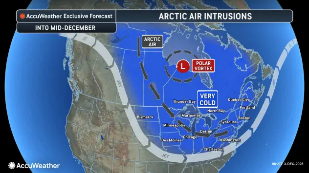
AccuWeather says a shifting polar vortex will allow multiple rounds of Arctic air to invade the central and eastern U.S. through the first half of December, and Michigan will not be spared from the cold.
"And temperatures across much of the Plains states — Northern Plains, Minnesota — are gonna be like 10 to 20 degrees below zero when they get up (Thursday) morning," Lundberg said. "That kinda cold isn't quite coming our way, but it is still going to be much below average for the foreseeable future."
As the Arctic air moves into Southeast Michigan on Thursday, Lundberg said it'll be breezy and very cold, despite some sun, with a high of only 25 degrees in Detroit, feeling more like 18 with the wind chill, Lundberg said.
Thursday night, it'll be very cold, with a low of 10 degrees in Detroit and down into the single digits in the suburbs. "The record is in reach of 6, set in 1974," Lundberg said. "I don't think we quite get there, but it's that kind of a cold air mass."
It'll be another frigid day on Friday, with clouds, some sun. and a high of 27 degrees, feeling more like 19.
"And as we go into Saturday and Sunday, the cold really continues," Lundberg said, with highs both days reaching only into the low to-mid 30s.
Looking ahead, there's no relief in sight. AccuWeather Lead Long-Range Meteorologist Paul Pastelok said the Artic air outbreak this week will be the first of probably three such rounds.
"Another cold blast is likely next week and a third the week after that," Pastelok said. "The waves of Arctic air will lead to significant surges in energy demands."
While it's too soon to tell, Metro Detroit could be looking at highs only into the 30s from now until Christmas Day. Check the extended daily AccuWeather forecast HERE.
As for snow, AccuWeather the next chance for anything significant in Metro Detroit will be Tuesday morning (12/9). There could be more snow on Wednesday (12/10), potentially mixed with rain in the morning.
Stay with WWJ for the latest on current conditions during traffic and weather, every 10 minutes on the 8s. >>LISTEN LIVE!!