DETROIT (WWJ) - Be alert and prepared: that's the warning being repeated from weather experts and local officials in Metro Detroit as strong, potentially dangerous storms threaten all of Southeast Michigan on Wednesday.
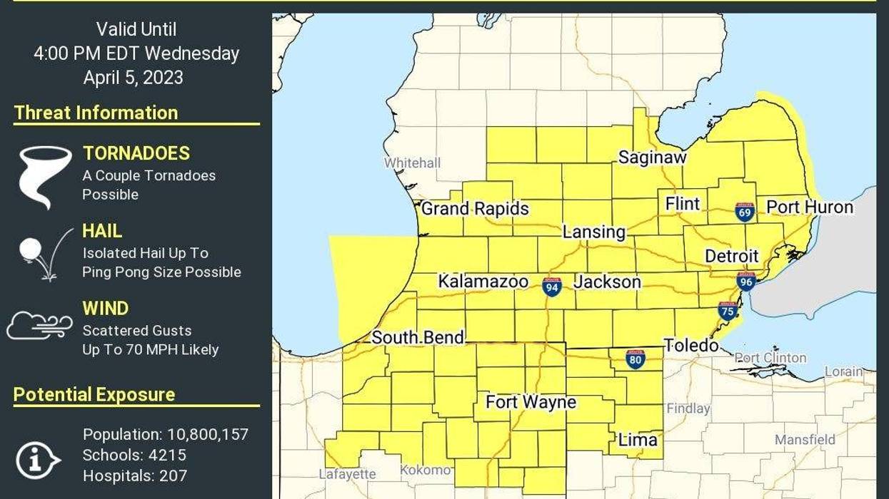
The National Weather Service has issued a Tornado Watch for all of Southeast Michigan now until 4 p.m. as residents from Mid-Michigan down to the suburbs of Detroit and over west to the shores of Lake Michigan are all at an 'enhanced' risk for severe weather forecasted to bring flooding rains, hail roughly 2" in diameter, wind gusts over 70 mph and strong tornadoes.
The watch encompasses all counties in Metro Detroit and beyond, including Genesee, Jackson, Lapeer, Lenawee, Livingston, Macomb, Monroe, Oakland, Sanilac, St. Clair, Washtenaw, and Wayne. The watch also effects residents in Allen, Barry, Bay, Berrien, Branch, Calhoun, Cass, Clinton, Easton, Gratiot, Hillsdale, Huron, Ingham, Ionia, Isabella, Kent, Mecosta, Midland, Montclam, Ottawa, Saginaw, Shiawassee, St. Joseph, Tuscola, and Van Buren.
In all, 10.8 million Michiganders are under the threat of potentially dangerous tornadoes.
"A powerful low pressure system will lift into the western Great Lakes bringing a warm and humid air mass preceding a cold front," the NWS stated. "This will fuel numerous to widespread thunderstorm late this morning through the early afternoon."
Experts warned that "numerous clusters of storms" are expected to race southwest to the northeast at around 50 to 60 mph during the late morning and early to mid-afternoon hours.
"This is going to be a situation you have to keep tuned to WWJ as we go through the day and listen and heed these warnings," AccuWeather Meteorologist Dean Devore advised.
DeVore said windy and warm temperatures of up to 75° will usher in the severe weather threat, which is estimated to impact Michigan between 11 a.m. and 4 p.m. However, he warned everyone should be aware of current weather conditions no matter the time on Wednesday and be prepared to act.
A strong cold front is expect to push through a corridor stretching from Chicago to Detroit that will being scattered severe storms posing an "enhanced" risk for the development of tornadoes, flooding and more.
The National Weather Service for Detroit/Pontiac said shortly before 8 a.m. that there were currently evaluating new data coming into their office -- not an hour later, a tornado watch was issued.
"Be on high alert and be prepared for flooding," WWJ's Mike Campbell warned as officials with the Great Lakes Water Authority advised residents in low-lying areas to take precautions.
Locally heavy rain associated with the storms is predicted to bring half inch of rainfall per hour, Campbell reported.
"The GLWA Chief Operating Officer of Waste Water Operating Services says already the regional system is near capacity and it is designed to handle the additional flow, but the GLWA is asking residents again in low-lying areas, in particular that are prone to flooding in heavy rainfall, to remain vigilant."
The GLWA advised all valuables be removed from basements for the time being.
DTE Energy has placed their crews on high alert in response to the storms which carry the potential to cause power outages due to high winds.
"The National Weather Service is advising that there is a potential for severe weather today, including large hail, damaging winds and tornadoes," DTE said in a update about the storms on their Outage Center. "Wind gusts up to 60 mph are possible, which can cause trees and branches to fall on our equipment resulting in power outages. Our Storm Response Teams are ready to restore power as quickly and safely as possible."
DTE asked all residents to be safe as the day goes on and to remember to stay at least 25 feet from any downed power lines and assume they are live and dangerous.
More than 50 crews are scheduled to leave DTE's Emergency Response Center in Redford to perform maintenance prior to the storms' arrival.
"They're ready to go, working hard to get ready for this storm," WWJ's Charlie Langton said live from the scene as the DTE trucks took off just before 8:40 a.m.
DTE has asked residents to report any outage or downed line on their website at: https://outage.dteenergy.com/report-down-line.
More on today's top stories: