METRO DETROIT (WWJ) - If dangerous heat and damaging storms were arrows, Metro Detroit is the bullseye -- and forecasters say a direct hit is imminent this week.
According to AccuWeather meteorologists, deadly heat that's been scorching the American Southwest will begin spreading into Michigan and most of the Midwest from the middle to the latter part of this week with temperatures climbing to their highest point so far this year.
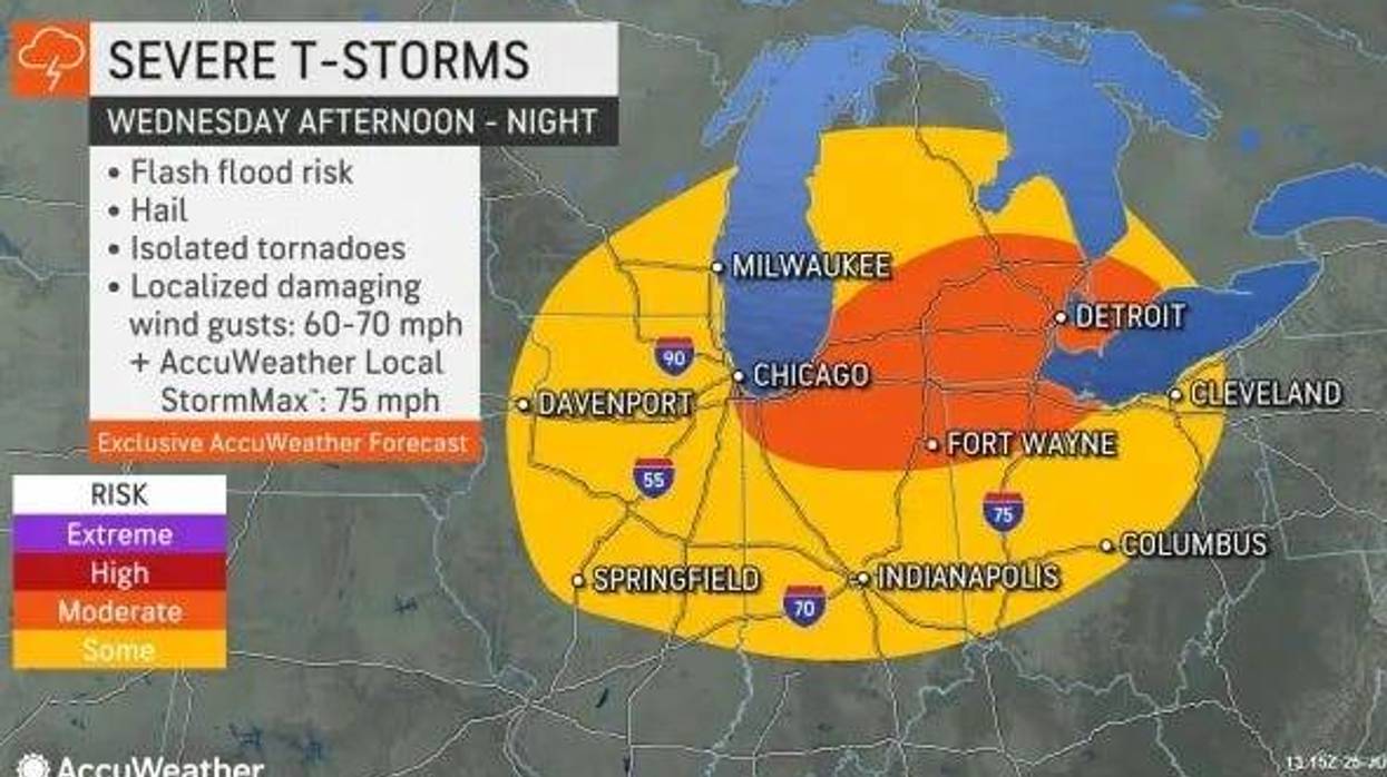
But as the heat builds, the high potential for severe weather is expected to track across the region on Wednesday afternoon and into the evening.
"All of Southeast Michigan will have potential for severe weather, but the highest threat area will be located south of a line from Lansing to Pontiac," the National Weather Service said in a Tuesday morning update. "All severe threats will be possible."
Those threats include multiple isolated tornadoes, damaging winds greater than 60 mph, hail greater have 1" in diameter and heavy rainfall that could lead to localized flash flooding.
The National Oceanic and Atmospheric Administration's Storm Prediction Center is tracking a disturbance from a mid-level high currently extending over the southern U.S. It's influence will eventually lead to the development of scatter showers and thunderstorms, which -- combined with the daytime heat and humidity -- have the potential to explode into dangerous supercell risk.
According to NOAA, a supercell thunderstorm is described as a storm that "possesses a structure have been observed to generate the vast majority of long-lived strong and violent (F2-F5) tornadoes, as well as downburst damage and large hail."
In addition, the conditions at play also create a great risk of a bowing segment, which experts say is an arched, bowed out line of thunderstorms that carry damaging straight-line winds near the "crest" or center.
In simpler terms, Michiganders in the southern regions of the Lower Peninsula should prepare now for yet another wild round of bad weather.
"Some of the storms could survive across multiple states for hundreds of miles as they form and move to the east-southeast through midweek," AccuWeather meteorologists said.
NOAA storm experts warned the biggest threats are expected to strike in the later afternoon to late evening, but a more exact timeframe is expected to be released as the forecast becomes more stable.
"Be weather aware and ready to act," the National Weather Service strongly advised. "Have multiple ways to receive warning information!"
But even after the severe weather threat wanes down on Wednesday, it's riding on a "dome of heat" which will move into the Metro Detroit area on Thursday.
While Detroit won't see the soaring 126 degrees heat recorded in Death Valley -- a few degrees shy of the daily record -- at least 45 states and over 100 million Americans will bake in high temperatures of 90 degrees or higher at some point this week.
Ann Arbor to Saginaw to Monroe to Detroit will all experience hot and muggy conditions with heat index values approaching 100 degrees on Thursday and Friday.
According to AccuWeather, this week will see the highest temperatures so far this summer in Detroit.
Experts are advising residents to stay in air-conditioned environment when possible in addition to "limiting vigorous physical activity during the peak of the heat during the midday and afternoon and increase the intake of non-alcoholic fluids to reduce the risk of heat exhaustion and heat stroke."
But relief is on the way. By the start of next week, cool Canadian air will swoop down into the Midwest, providing much more comfortable temperatures. It will also push moisture farther south, ending the threat for storms for at least a couple of days.
State officials with MIREADY advise the following actions to better prepare yourself and your family ahead of severe storm activity:
• Remove dead or rotting trees and branches that could fall on your home with strong winds.
• Postpone outdoor activities until the storm has passed.
• Secure outdoor objects that could be blown around, such as garbage cans and patio furniture.
• Close all windows and blinds.
• Charge cell phones and other wireless communication devices.
• Sign up to receive text or e-mail alerts from your local media, weather provider or the National Weather Service.
• Plan a way to monitor local weather and news while in shelter.
• Identify the safest shelter location in your home; it should be on the lowest level, away from windows and doors.
• Prepare for a power outage.
Stay tuned to the latest weather updates with WWJ Traffic and Weather on the :08s by listening LIVE.
More on today's top stories: