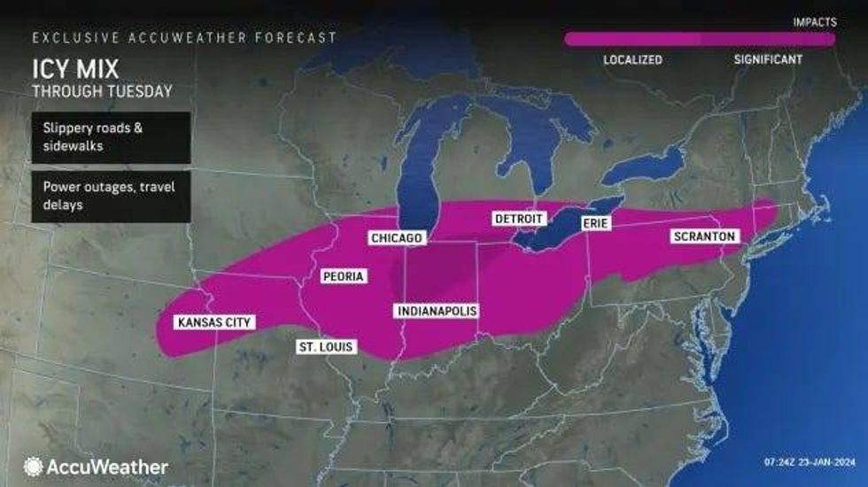
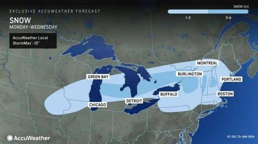
DETROIT (WWJ) - A major warm up is on the way for Metro Detroit, but first, residents must navigate through snow, sleet and freezing rain plaguing freeways around the area on Tuesday.
A Winter Weather Advisory remains in effect for Livingston, Oakland, Macomb, Washtenaw, Wayne, Lenawee and Monroe counties until 4 p.m. Tuesday as mixed precipitation continues to fall.
The National Weather Service in Detroit said snow accumulations could reach up to 3 inches and with ice accumulations up to two tenths of an inch -- and it couldn't come at a worse time as drivers prepare to head out for their morning commute.
According to AccuWeather, ice that builds up to 0.25 of an inch or greater is heavy enough to weigh trees down, causing them to break and trigger power outages.
WWJ's AccuWeather meteorologist Dean DeVore said drivers should be extra suspicious of wet roadways as black ice -- not puddles -- could be lurking.
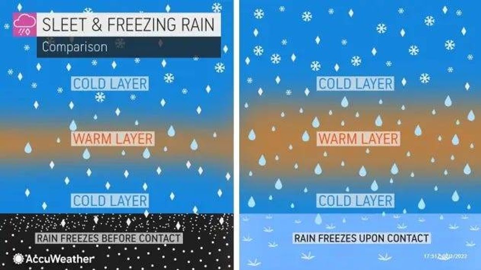
"We have that unique situation because of the entirety of our area being under the deep freeze for the better part of a week and a half that we are seeing freezing rain developing," DeVore explained. "Even with the air temperature, remember the air temperature is recorded about 3 to 4 feet off the ground, but that surface... it's falling on to, if it's untreated, still could be a lot colder than that and creating freezing rain, even though the air temperature is above freezing."
 AccuWeather
DeVore said its a mixed bag as far was what Metro Detroiters are seeing outside their homes with sleet, rain and snow all falling depending on the locations as temperatures continue to battle right at the freezing mark.
"It's just a wet mess here," DeVore said. "We wanted the warmer air, but certainly in this time of year, it's hard to get good weather with warmer air over this much cold ground."
WWJ traffic reporter Michelle Peña said numerous crashes and spin outs are causing traffic tie ups across Metro Detroit.
"There's a laundry list of issues out there," she warned, "Icy roads this morning some areas with black ice."
According to Peña, there quite a few issues on I-275 with a spin out crash blocking the two right lanes southbound I-275 at Six Mile with another crash affected southbound 275 at Michigan Avenue.
"At I-94, there's a crash in the right lane and an accident on the northbound side of Ann Arbor Road as well," Peña said. "Taking a look on I-75 heading northbound after Baldwin andI- 75 southbound after East Holly Road, a number of spin out crashes in that area. I-75 southbound at 12 Mile, that accident is still blocking the right shoulder as well as one on the right side of the northbound side of I-75 just after 14 Mile."
A three car spin out crash affected the right side ditch of I-94 westbound before Middlebelt Road.
"Again, it really just depends on where you are," Peña sad of road conditions. "Allow plenty of extra drive time at this point."
Roadways were the only thing affected by the weather. Detroit Metro Airport closed, per the FAA, with a ground stop that was in effect until 6 a.m., due to icing on the runway.
Other area airports, such as Saginaw, also shut down further complicating issues as the airfields for diversions were causing difficulties for incoming flights.
Officials warned travelers to to expect cascading delays throughout the morning and to check with their airline for any questions about their flight.
As the morning goes on, DeVore said the Metro area will still see sleet pellets and some snow pellets mixed in, but it will dissipate later on.
The sleet and freezing rain will continue into the afternoon hours before it begins to tamper off -- but daytime highs will continue to struggle.
"But these temperatures are not going to go anywhere," DeVore said. "They're kind of hovering in the low to mid 30s, some rain and pockets of freezing rain as we go through the rest day into the night into tomorrow."
 AccuWeather
 AccuWeather
Rain and drizzle is expected to continue before the next possible round of traffic trouble set to move in on Wednesday. DeVore said thick patches of fog could creep up as temperatures begin to spike into the 40s.
"Thursday and by Friday and Saturday, I think we're dry for the most part temperatures up to about 40 to 45," DeVore said. "We have another system that looks like it comes in Saturday night into Sunday."
Stay current on the updates on WWJ LIVE with Traffic and Weather on the :08s